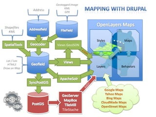
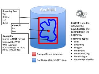
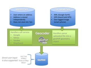
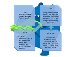
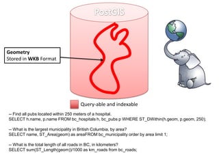
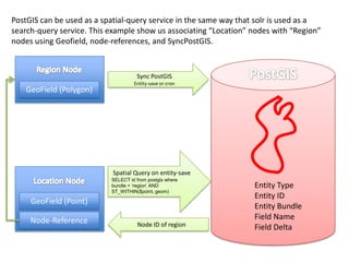
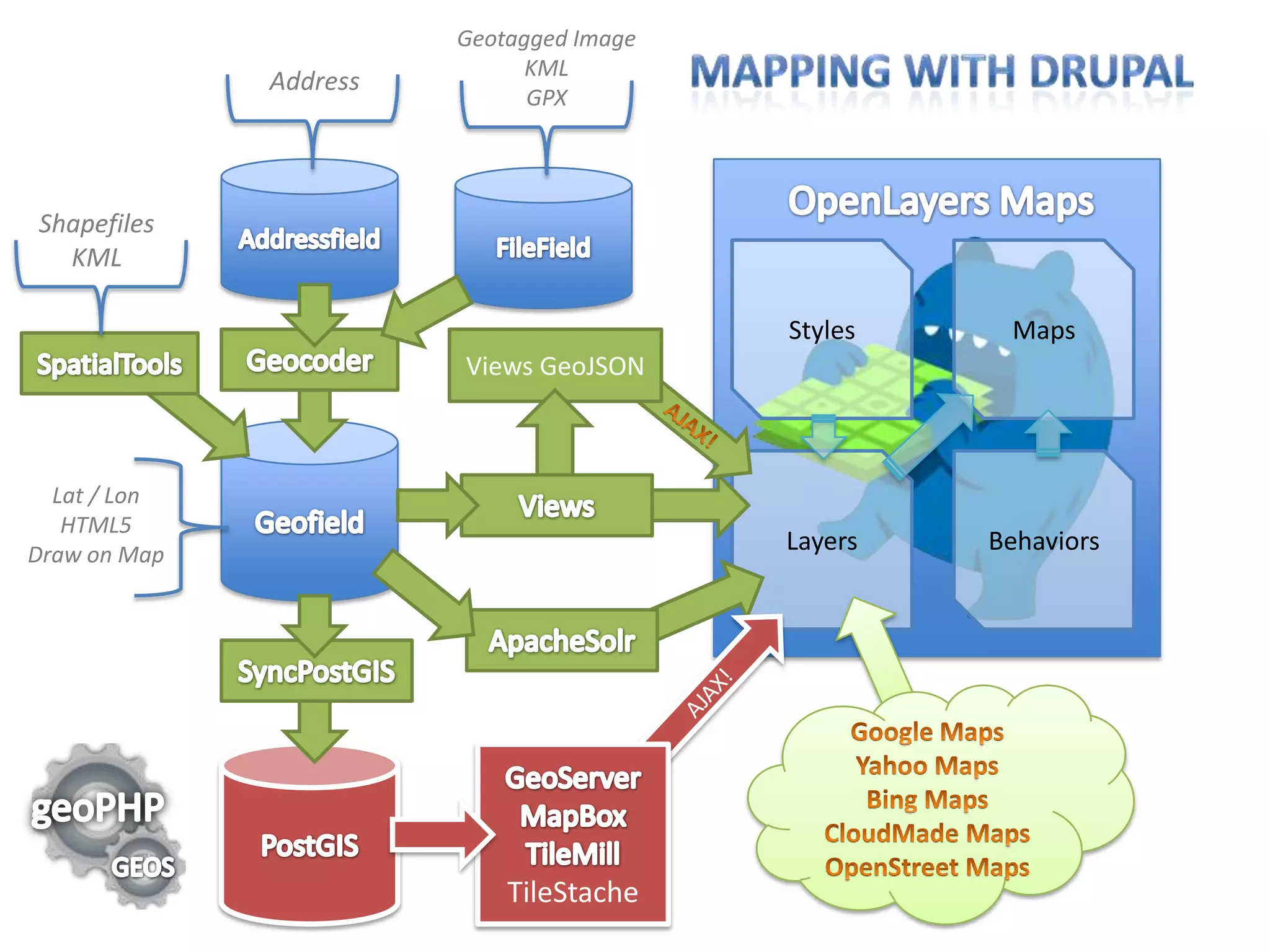
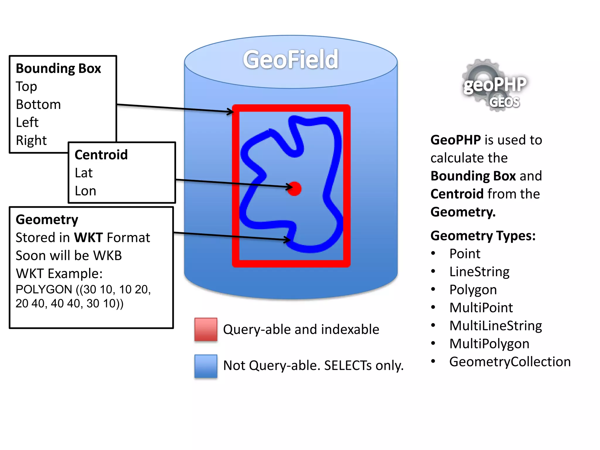
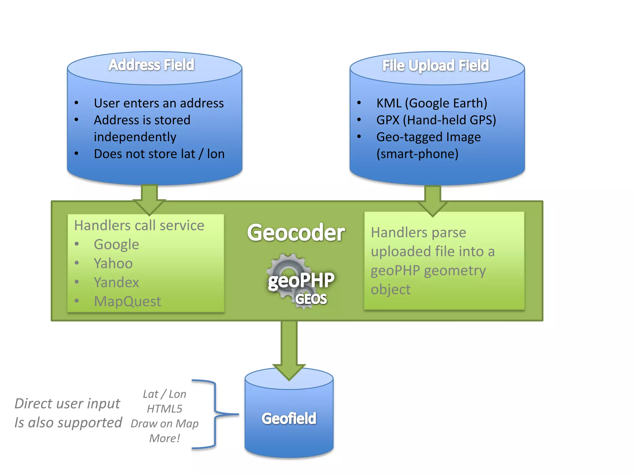
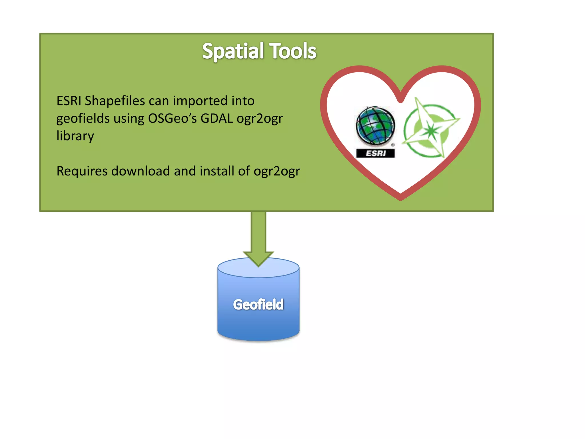
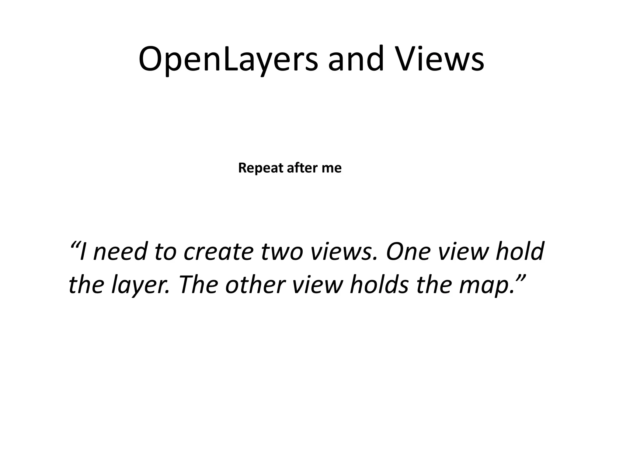
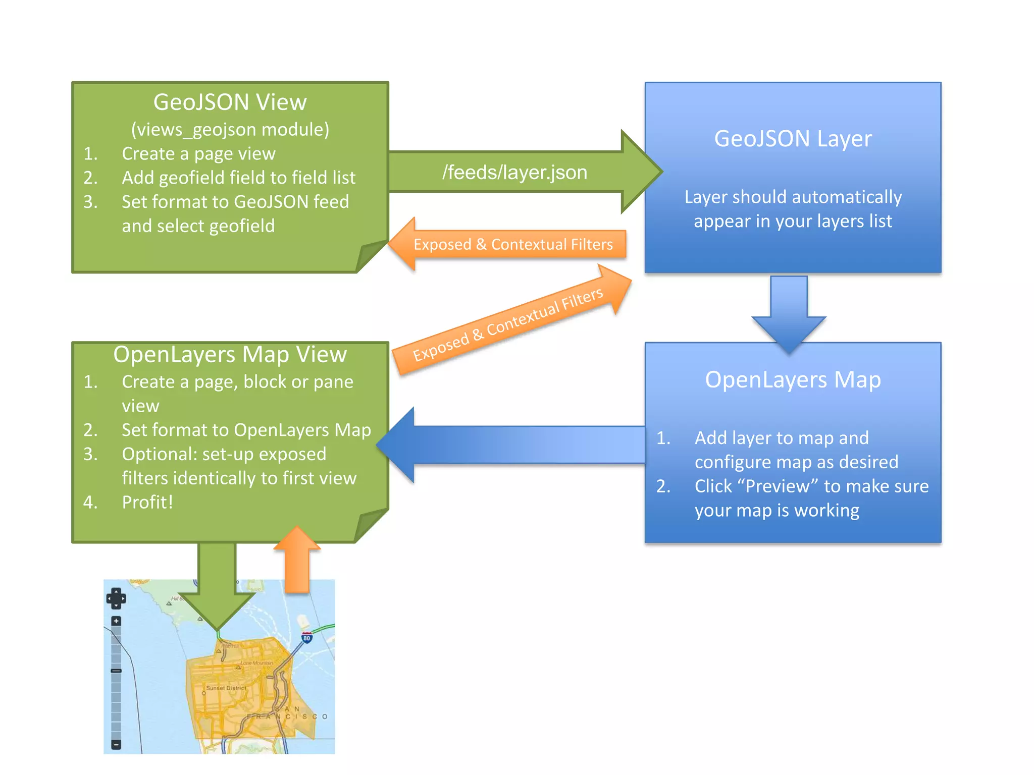
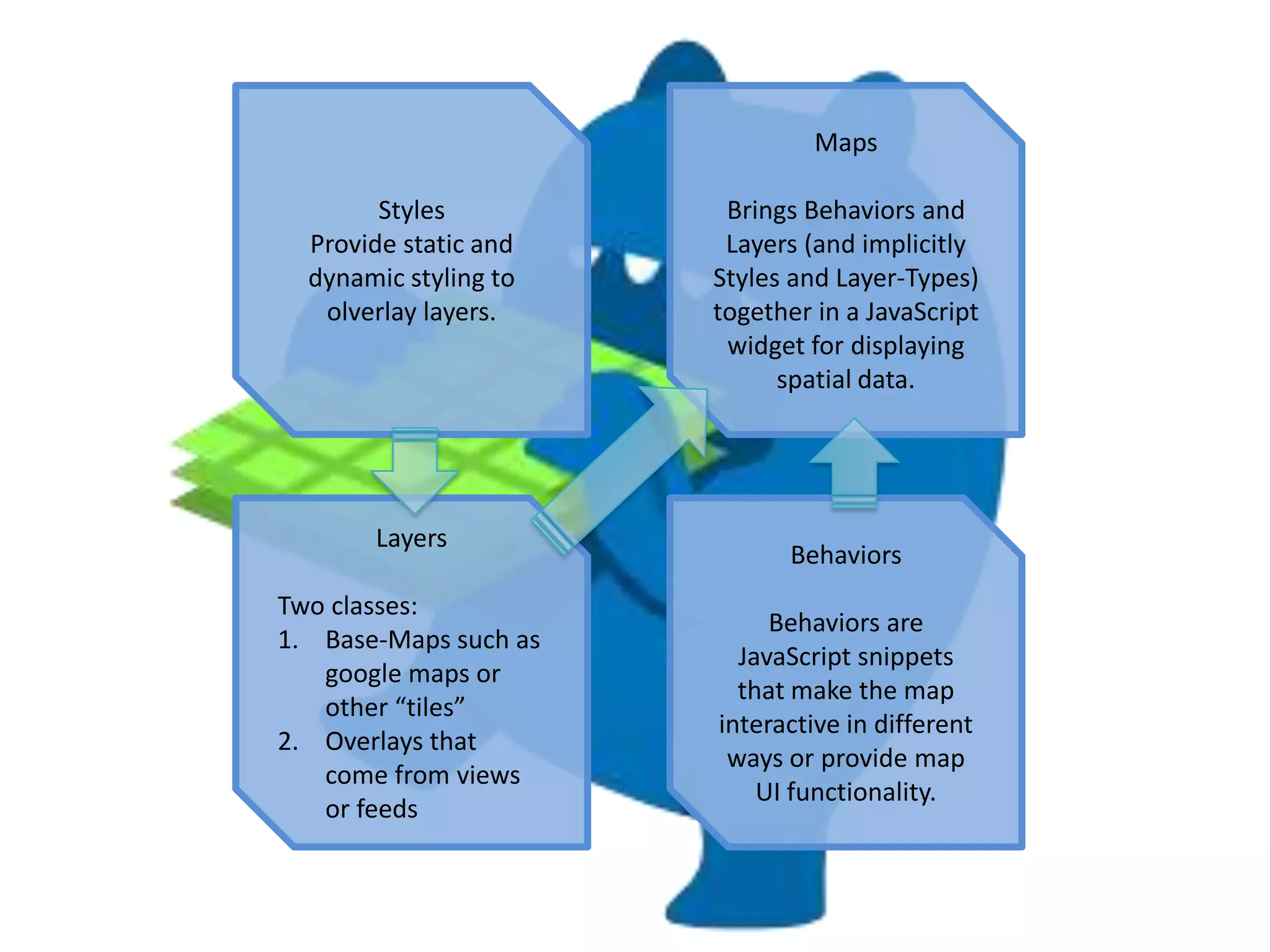
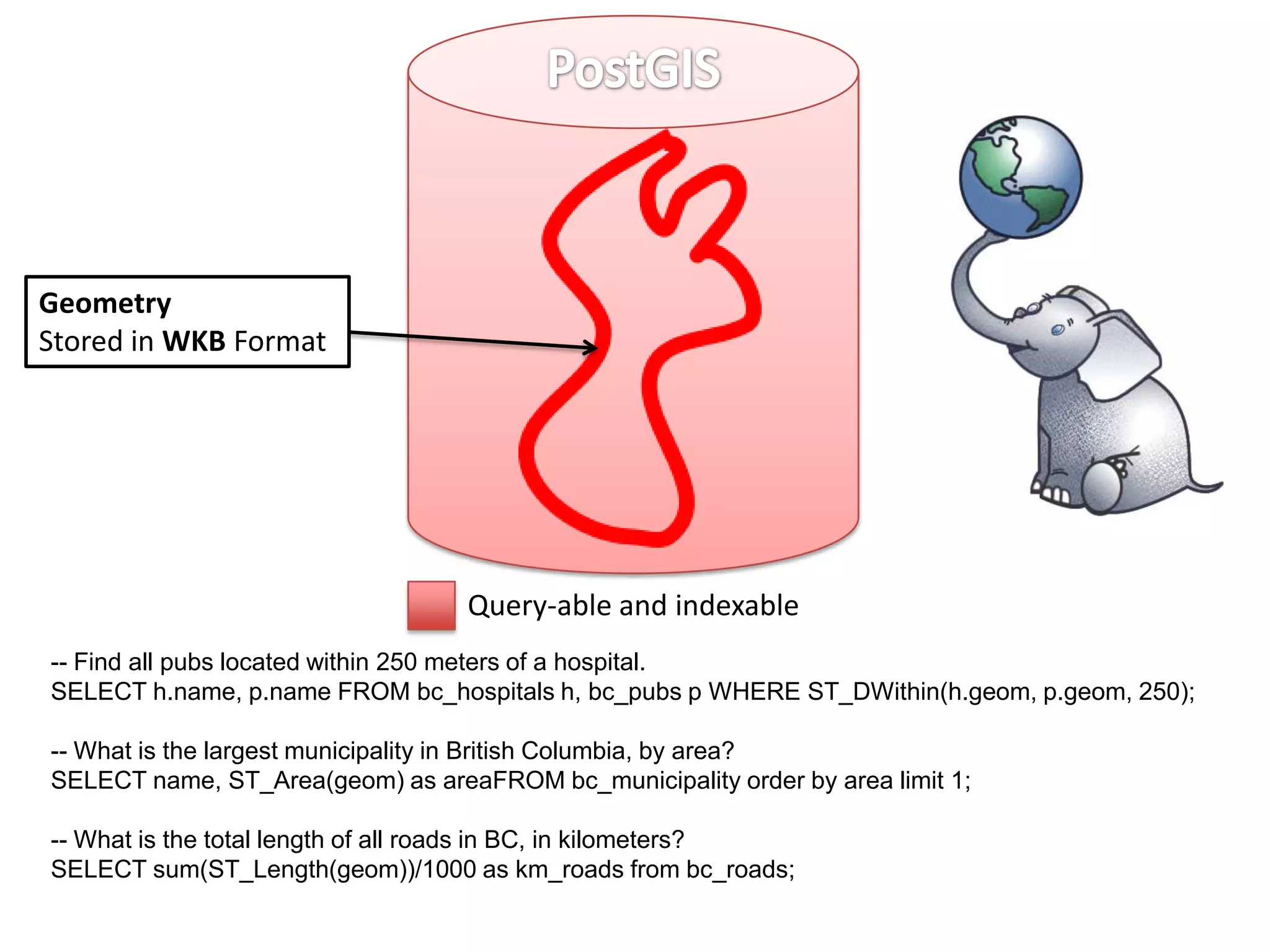
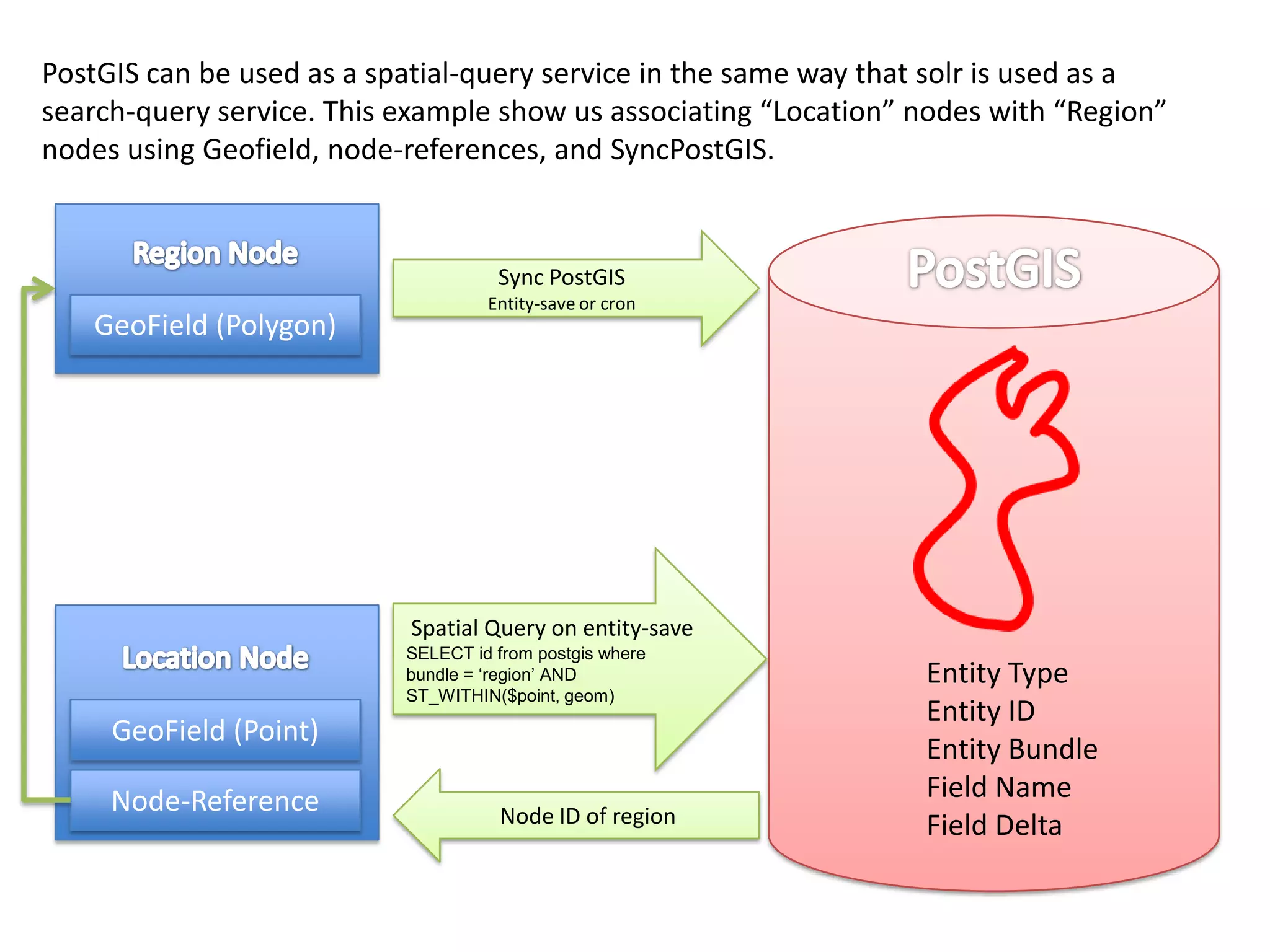
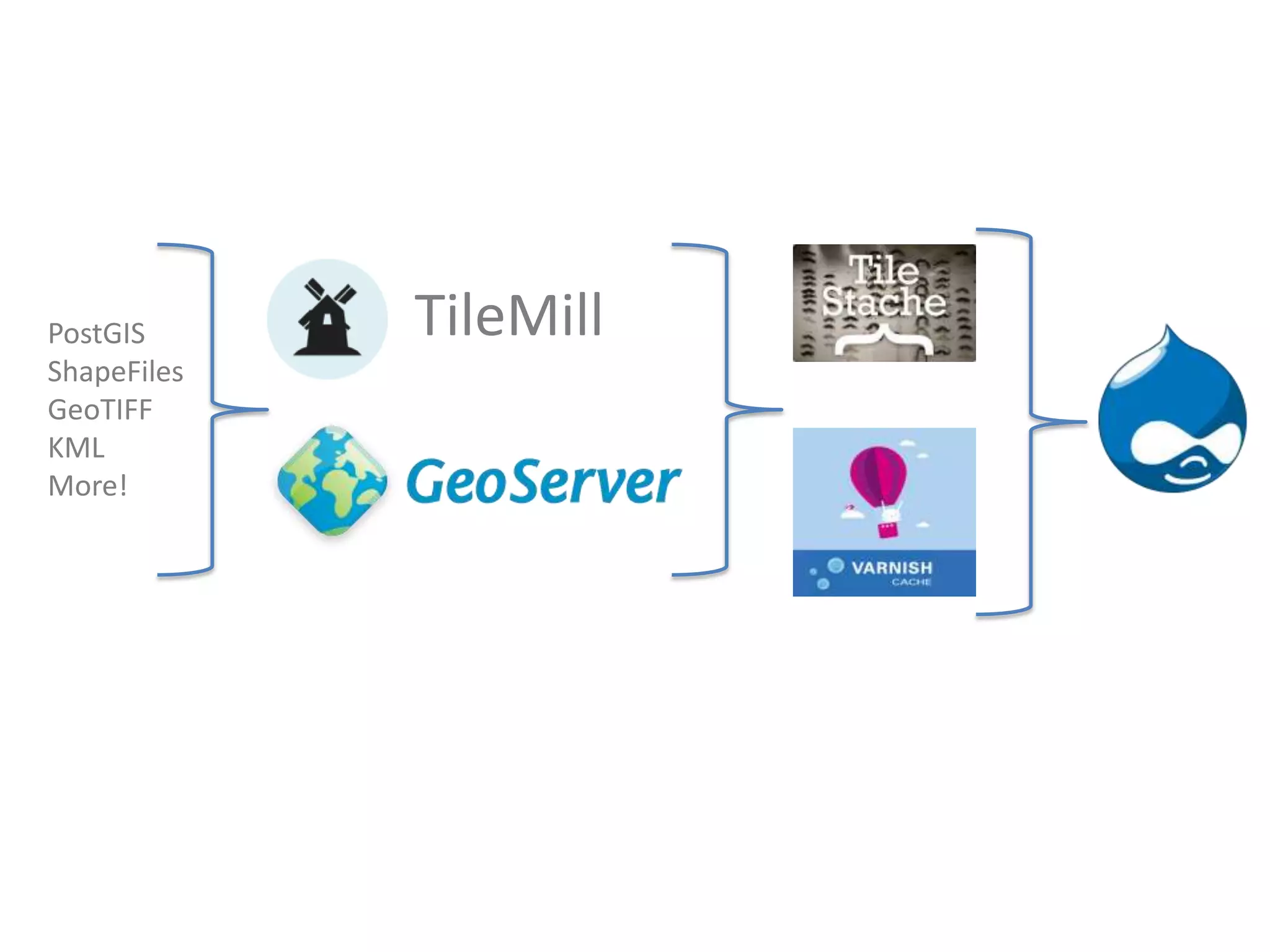
KEMBAR78
Drupal mapping modules | PPTX
Mapping With Drupal
Geotagged Image
                              KML
              Address
                              GPX


Shapefiles
  KML

                                          Styles    Maps
                        Views GeoJSON


  Lat / Lon
   HTML5
Draw on Map
                                          Layers   Behaviors


                            TileStache
Bounding Box
Top
Bottom
Left
Right                                                     GeoPHP is used to
        Centroid                                          calculate the
        Lat                                               Bounding Box and
        Lon                                               Centroid from the
                                                          Geometry.
Geometry
Stored in WKT Format                                      Geometry Types:
Soon will be WKB                                          • Point
WKT Example:                                              • LineString
POLYGON ((30 10, 10 20,                                   • Polygon
20 40, 40 40, 30 10))                                     • MultiPoint
                          Query-able and indexable        • MultiLineString
                                                          • MultiPolygon
                          Not Query-able. SELECTs only.   • GeometryCollection
•   User enters an address     •   KML (Google Earth)
         •   Address is stored          •   GPX (Hand-held GPS)
             independently              •   Geo-tagged Image
         •   Does not store lat / lon       (smart-phone)


         Handlers call service              Handlers parse
         • Google                           uploaded file into a
         • Yahoo                            geoPHP geometry
         • Yandex                           object
         • MapQuest


                      Lat / Lon
Direct user input      HTML5
Is also supported   Draw on Map
                       More!
ESRI Shapefiles can imported into
geofields using OSGeo’s GDAL ogr2ogr
library

Requires download and install of ogr2ogr
Latitude, Longitude 127 24’ 66’’ N, 23 23’ 56’’ W

  GeoJSON {"type":"Point","coordinates":[-123.3,30.78]}

  WKT POLYGON ((30 10, 10 20, 20 40, 40 40, 30 10))


OpenLayers Map
OpenLayers and Views

              Repeat after me


“I need to create two views. One view hold
the layer. The other view holds the map.”
GeoJSON View
      (views_geojson module)
                                                                                GeoJSON Layer
1.   Create a page view
2.   Add geofield field to field list        /feeds/layer.json
3.   Set format to GeoJSON feed                                              Layer should automatically
     and select geofield                                                      appear in your layers list
                                         Exposed & Contextual Filters


     OpenLayers Map View
1.   Create a page, block or pane                                              OpenLayers Map
     view
2.   Set format to OpenLayers Map                                       1.    Add layer to map and
3.   Optional: set-up exposed                                                 configure map as desired
     filters identically to first view                                  2.    Click “Preview” to make sure
4.   Profit!                                                                  your map is working
Maps

        Styles          Brings Behaviors and
  Provide static and    Layers (and implicitly
  dynamic styling to   Styles and Layer-Types)
   olverlay layers.    together in a JavaScript
                        widget for displaying
                             spatial data.


       Layers
                             Behaviors
Two classes:
                            Behaviors are
1. Base-Maps such as
                         JavaScript snippets
   google maps or
                         that make the map
   other “tiles”
                       interactive in different
2. Overlays that
                        ways or provide map
   come from views
                           UI functionality.
   or feeds
Geometry
Stored in WKB Format


                                  Query-able and indexable
-- Find all pubs located within 250 meters of a hospital.
SELECT h.name, p.name FROM bc_hospitals h, bc_pubs p WHERE ST_DWithin(h.geom, p.geom, 250);

-- What is the largest municipality in British Columbia, by area?
SELECT name, ST_Area(geom) as areaFROM bc_municipality order by area limit 1;

-- What is the total length of all roads in BC, in kilometers?
SELECT sum(ST_Length(geom))/1000 as km_roads from bc_roads;
PostGIS can be used as a spatial-query service in the same way that solr is used as a
search-query service. This example show us associating “Location” nodes with “Region”
nodes using Geofield, node-references, and SyncPostGIS.


                                     Sync PostGIS
                                    Entity-save or cron
   GeoField (Polygon)


                           Spatial Query on entity-save
                           SELECT id from postgis where
                           bundle = ‘region’ AND                  Entity Type
                           ST_WITHIN($point, geom)
                                                                  Entity ID
     GeoField (Point)
                                                                  Entity Bundle
     Node-Reference                                               Field Name
                                     Node ID of region            Field Delta
PostGIS      TileMill
ShapeFiles
GeoTIFF
KML
More!

Drupal mapping modules

  • 1.
  • 2.
    Geotagged Image KML Address GPX Shapefiles KML Styles Maps Views GeoJSON Lat / Lon HTML5 Draw on Map Layers Behaviors TileStache
  • 3.
    Bounding Box Top Bottom Left Right GeoPHP is used to Centroid calculate the Lat Bounding Box and Lon Centroid from the Geometry. Geometry Stored in WKT Format Geometry Types: Soon will be WKB • Point WKT Example: • LineString POLYGON ((30 10, 10 20, • Polygon 20 40, 40 40, 30 10)) • MultiPoint Query-able and indexable • MultiLineString • MultiPolygon Not Query-able. SELECTs only. • GeometryCollection
  • 4.
    User enters an address • KML (Google Earth) • Address is stored • GPX (Hand-held GPS) independently • Geo-tagged Image • Does not store lat / lon (smart-phone) Handlers call service Handlers parse • Google uploaded file into a • Yahoo geoPHP geometry • Yandex object • MapQuest Lat / Lon Direct user input HTML5 Is also supported Draw on Map More!
  • 5.
    ESRI Shapefiles canimported into geofields using OSGeo’s GDAL ogr2ogr library Requires download and install of ogr2ogr
  • 6.
    Latitude, Longitude 12724’ 66’’ N, 23 23’ 56’’ W GeoJSON {"type":"Point","coordinates":[-123.3,30.78]} WKT POLYGON ((30 10, 10 20, 20 40, 40 40, 30 10)) OpenLayers Map
  • 7.
    OpenLayers and Views Repeat after me “I need to create two views. One view hold the layer. The other view holds the map.”
  • 8.
    GeoJSON View (views_geojson module) GeoJSON Layer 1. Create a page view 2. Add geofield field to field list /feeds/layer.json 3. Set format to GeoJSON feed Layer should automatically and select geofield appear in your layers list Exposed & Contextual Filters OpenLayers Map View 1. Create a page, block or pane OpenLayers Map view 2. Set format to OpenLayers Map 1. Add layer to map and 3. Optional: set-up exposed configure map as desired filters identically to first view 2. Click “Preview” to make sure 4. Profit! your map is working
  • 9.
    Maps Styles Brings Behaviors and Provide static and Layers (and implicitly dynamic styling to Styles and Layer-Types) olverlay layers. together in a JavaScript widget for displaying spatial data. Layers Behaviors Two classes: Behaviors are 1. Base-Maps such as JavaScript snippets google maps or that make the map other “tiles” interactive in different 2. Overlays that ways or provide map come from views UI functionality. or feeds
  • 10.
    Geometry Stored in WKBFormat Query-able and indexable -- Find all pubs located within 250 meters of a hospital. SELECT h.name, p.name FROM bc_hospitals h, bc_pubs p WHERE ST_DWithin(h.geom, p.geom, 250); -- What is the largest municipality in British Columbia, by area? SELECT name, ST_Area(geom) as areaFROM bc_municipality order by area limit 1; -- What is the total length of all roads in BC, in kilometers? SELECT sum(ST_Length(geom))/1000 as km_roads from bc_roads;
  • 11.
    PostGIS can beused as a spatial-query service in the same way that solr is used as a search-query service. This example show us associating “Location” nodes with “Region” nodes using Geofield, node-references, and SyncPostGIS. Sync PostGIS Entity-save or cron GeoField (Polygon) Spatial Query on entity-save SELECT id from postgis where bundle = ‘region’ AND Entity Type ST_WITHIN($point, geom) Entity ID GeoField (Point) Entity Bundle Node-Reference Field Name Node ID of region Field Delta
  • 12.
    PostGIS TileMill ShapeFiles GeoTIFF KML More!

Editor's Notes

  • #4 Howgeofield stores data
  • #5 Getting data into geofield
  • #6 NEED MORE INFO
  • #7 Geofield Formatters