Download as PDF, PPTX

![[ from Jpatokal at wikimedia.org ]
https://secure.wikimedia.org/wikipedia/commons/wiki/File:World-airline-routemap-2009.png](https://image.slidesharecdn.com/studerpresentation-130625132628-phpapp01/85/Geospatial-Enhancements-in-MongoDB-2-4-4-320.jpg)
![[ from Jpatokal at wikimedia.org ]
https://secure.wikimedia.org/wikipedia/commons/wiki/File:World-airline-routemap-2009.png](https://image.slidesharecdn.com/studerpresentation-130625132628-phpapp01/85/Geospatial-Enhancements-in-MongoDB-2-4-5-320.jpg)

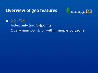
![// Make a flat 2d index [-180 -> 180)
> db.coll.ensureIndex(
{ location : "2d", type : 1 } )
// Insert some point data
> db.coll.insert({ name : "Shake Shack",
type : "rest",
location : [ -73.9881353, 40.7415064 ]
})
> db.coll.insert({ name : "Park Avenue
Tavern", type : "bar",
location : [ -73.9786924, 40.7502231 ]
})](https://image.slidesharecdn.com/studerpresentation-130625132628-phpapp01/85/Geospatial-Enhancements-in-MongoDB-2-4-9-320.jpg)
![// Find in Manhattan Mall
> db.coll.find({ location : { $geoWithin : {
$polygon : [[ -73.9884761, 40.7491204 ],
[ -73.988829, 40.7486387 ],
[ -73.9901297, 40.7491856 ],
[ -73.9897768, 40.7496673 ],
[ -73.9884761, 40.7491204 ]] }}},
type : "rest" })
// Find near Washington Square (center)
> db.coll.find({ location : {
$geoNear : [ -73.7695467, 42.6622728 ] },
type : "rest" });](https://image.slidesharecdn.com/studerpresentation-130625132628-phpapp01/85/Geospatial-Enhancements-in-MongoDB-2-4-10-320.jpg)

![GeoJSON
● Widely supported open JSON standard
http://www.geojson.org/
● Simple language:
{ type : 'Point',
coordinates : [<lon>, <lat>] }
{ type : 'LineString',
coordinates : [[<lon>, <lat>],...] }
{ type : 'Polygon',
coordinates : [[[<lon>,<lat>],...],...]}
+ other MultiXXX types (future) ...](https://image.slidesharecdn.com/studerpresentation-130625132628-phpapp01/85/Geospatial-Enhancements-in-MongoDB-2-4-13-320.jpg)
![// Make a spherical 2d compound index
> db.coll.ensureIndex(
{ type : 1, location : "2dsphere" } )
// Insert Park Avenue
> db.coll.insert(
{ name : "Park Avenue", type : "road",
location : { type : 'LineString',
coordinates : [
[ -73.9359712600708, 40.80942429324451],
[ -73.93676519393921, 40.80820620367037],
... ]} });](https://image.slidesharecdn.com/studerpresentation-130625132628-phpapp01/85/Geospatial-Enhancements-in-MongoDB-2-4-14-320.jpg)
![// Insert Great Hill
> db.coll.insert(
{ name : "Great Hill", type : "park",
location : { type : 'Polygon',
coordinates : [[
[ -73.95841598510742, 40.79724239132546],
[ -73.95817995071411, 40.79691751000055],
... ]]} });](https://image.slidesharecdn.com/studerpresentation-130625132628-phpapp01/85/Geospatial-Enhancements-in-MongoDB-2-4-15-320.jpg)
![// Find docs with geometry that intersects
// a route
> db.coll.find({ location :
{ $geoIntersects : { $geometry :
{ type : 'LineString',
// Run coordinates
coordinates : [
[ -73.95586252212524, 40.77964777966238 ],
[ -73.95886659622192, 40.78091513739611 ],
... ]} }}})](https://image.slidesharecdn.com/studerpresentation-130625132628-phpapp01/85/Geospatial-Enhancements-in-MongoDB-2-4-16-320.jpg)


![> db.ny.aggregate([
// Find everything in MidTown/Hell's Kitchen
{ $match : { geo: { $geoWithin: { $geometry:
{ type: "Polygon", coordinates: [[
// Midtown/Hell's Kitchen
[ -73.9984130859375, 40.78028146155187 ],
[ -73.95240783691406, 40.76182096906601 ],
[ -73.96888732910156, 40.73945350425846 ],
[ -74.01420593261719, 40.75531957477602 ],
[ -73.9984130859375, 40.78028146155187 ]
]] } } } } },
...](https://image.slidesharecdn.com/studerpresentation-130625132628-phpapp01/85/Geospatial-Enhancements-in-MongoDB-2-4-24-320.jpg)
![...
// Organize stuff we want
{ $project :
{ tags : 1,
info : { name : "$name",
lonLat : "$geo.coordinates" }} },
{ $unwind : "$tags" },
// Count by tag types
{ $group : { _id : "$tags",
total : { $sum : 1 },
locs : { $push : "$info" } }}
]); // end](https://image.slidesharecdn.com/studerpresentation-130625132628-phpapp01/85/Geospatial-Enhancements-in-MongoDB-2-4-25-320.jpg)
![{ "result" : [
{ "_id" : "park", "total" : 18,
"locs" : [{
"name" : "Hells Kitchen Park",
"lonLat" : [ -73.9925, 40.7630556 ] },
...
{ "_id" : "bar", "total" : 28,
"locs" : [
{ "name" : "Landmark Tavern",
"lonLat" : [ -73.9963261, 40.7631922 ] },
{ "name" : "Pony Bar",
"lonLat" : [ -73.994236, 40.761723 ] },
...
...](https://image.slidesharecdn.com/studerpresentation-130625132628-phpapp01/85/Geospatial-Enhancements-in-MongoDB-2-4-26-320.jpg)
![> db.ny.aggregate([
// Find near Times Square
{ $geoNear : {
near : {
type: "Point",
// Times Square
coordinates: [ -73.98508787155151,
40.75905795418586 ] },
distanceField : "distance",
spherical : true, // 2dsphere
num : 1000 } },
...](https://image.slidesharecdn.com/studerpresentation-130625132628-phpapp01/85/Geospatial-Enhancements-in-MongoDB-2-4-27-320.jpg)
![...
// Organize stuff we want
{ $project :
{ tags : 1,
info : { name : "$name",
distance : "$distance",
lonLat : "$geo.coordinates" }} },
{ $unwind : "$tags" },
// Count by tag types
{ $group : { _id : "$tags",
total : { $sum : 1 },
locs : { $push : "$info" } }}
]); // end
...](https://image.slidesharecdn.com/studerpresentation-130625132628-phpapp01/85/Geospatial-Enhancements-in-MongoDB-2-4-28-320.jpg)
![{ "result" : [
{ "_id" : "park", "total" : 11,
"locs" : [{
"name" : "Ramone Aponte Park",
"distance" : 449.7417003854033, // m
"lonLat" : [ -73.9894444, 40.7613889 ]},
...
{ "_id" : "bar", "total" : 24,
"locs" : [{
"name" : "The Lambs Club",
"distance" : 275.0270424641914, // m
"lonLat" : [ -73.9963261, 40.7631922 ]},
...
...](https://image.slidesharecdn.com/studerpresentation-130625132628-phpapp01/85/Geospatial-Enhancements-in-MongoDB-2-4-29-320.jpg)
![[ from Jpatokal at wikimedia.org ]
https://secure.wikimedia.org/wikipedia/commons/wiki/File:World-airline-routemap-2009.png](https://image.slidesharecdn.com/studerpresentation-130625132628-phpapp01/85/Geospatial-Enhancements-in-MongoDB-2-4-30-320.jpg)


![[ from Jpatokal at wikimedia.org ]
https://secure.wikimedia.org/wikipedia/commons/wiki/File:World-airline-routemap-2009.png](https://image.slidesharecdn.com/studerpresentation-130625132628-phpapp01/75/Geospatial-Enhancements-in-MongoDB-2-4-4-2048.jpg)
![[ from Jpatokal at wikimedia.org ]
https://secure.wikimedia.org/wikipedia/commons/wiki/File:World-airline-routemap-2009.png](https://image.slidesharecdn.com/studerpresentation-130625132628-phpapp01/75/Geospatial-Enhancements-in-MongoDB-2-4-5-2048.jpg)
![// Make a flat 2d index [-180 -> 180)
> db.coll.ensureIndex(
{ location : "2d", type : 1 } )
// Insert some point data
> db.coll.insert({ name : "Shake Shack",
type : "rest",
location : [ -73.9881353, 40.7415064 ]
})
> db.coll.insert({ name : "Park Avenue
Tavern", type : "bar",
location : [ -73.9786924, 40.7502231 ]
})](https://image.slidesharecdn.com/studerpresentation-130625132628-phpapp01/75/Geospatial-Enhancements-in-MongoDB-2-4-9-2048.jpg)
![// Find in Manhattan Mall
> db.coll.find({ location : { $geoWithin : {
$polygon : [[ -73.9884761, 40.7491204 ],
[ -73.988829, 40.7486387 ],
[ -73.9901297, 40.7491856 ],
[ -73.9897768, 40.7496673 ],
[ -73.9884761, 40.7491204 ]] }}},
type : "rest" })
// Find near Washington Square (center)
> db.coll.find({ location : {
$geoNear : [ -73.7695467, 42.6622728 ] },
type : "rest" });](https://image.slidesharecdn.com/studerpresentation-130625132628-phpapp01/75/Geospatial-Enhancements-in-MongoDB-2-4-10-2048.jpg)
![GeoJSON
● Widely supported open JSON standard
http://www.geojson.org/
● Simple language:
{ type : 'Point',
coordinates : [<lon>, <lat>] }
{ type : 'LineString',
coordinates : [[<lon>, <lat>],...] }
{ type : 'Polygon',
coordinates : [[[<lon>,<lat>],...],...]}
+ other MultiXXX types (future) ...](https://image.slidesharecdn.com/studerpresentation-130625132628-phpapp01/75/Geospatial-Enhancements-in-MongoDB-2-4-13-2048.jpg)
![// Make a spherical 2d compound index
> db.coll.ensureIndex(
{ type : 1, location : "2dsphere" } )
// Insert Park Avenue
> db.coll.insert(
{ name : "Park Avenue", type : "road",
location : { type : 'LineString',
coordinates : [
[ -73.9359712600708, 40.80942429324451],
[ -73.93676519393921, 40.80820620367037],
... ]} });](https://image.slidesharecdn.com/studerpresentation-130625132628-phpapp01/75/Geospatial-Enhancements-in-MongoDB-2-4-14-2048.jpg)
![// Insert Great Hill
> db.coll.insert(
{ name : "Great Hill", type : "park",
location : { type : 'Polygon',
coordinates : [[
[ -73.95841598510742, 40.79724239132546],
[ -73.95817995071411, 40.79691751000055],
... ]]} });](https://image.slidesharecdn.com/studerpresentation-130625132628-phpapp01/75/Geospatial-Enhancements-in-MongoDB-2-4-15-2048.jpg)
![// Find docs with geometry that intersects
// a route
> db.coll.find({ location :
{ $geoIntersects : { $geometry :
{ type : 'LineString',
// Run coordinates
coordinates : [
[ -73.95586252212524, 40.77964777966238 ],
[ -73.95886659622192, 40.78091513739611 ],
... ]} }}})](https://image.slidesharecdn.com/studerpresentation-130625132628-phpapp01/75/Geospatial-Enhancements-in-MongoDB-2-4-16-2048.jpg)

![> db.ny.aggregate([
// Find everything in MidTown/Hell's Kitchen
{ $match : { geo: { $geoWithin: { $geometry:
{ type: "Polygon", coordinates: [[
// Midtown/Hell's Kitchen
[ -73.9984130859375, 40.78028146155187 ],
[ -73.95240783691406, 40.76182096906601 ],
[ -73.96888732910156, 40.73945350425846 ],
[ -74.01420593261719, 40.75531957477602 ],
[ -73.9984130859375, 40.78028146155187 ]
]] } } } } },
...](https://image.slidesharecdn.com/studerpresentation-130625132628-phpapp01/75/Geospatial-Enhancements-in-MongoDB-2-4-24-2048.jpg)
![...
// Organize stuff we want
{ $project :
{ tags : 1,
info : { name : "$name",
lonLat : "$geo.coordinates" }} },
{ $unwind : "$tags" },
// Count by tag types
{ $group : { _id : "$tags",
total : { $sum : 1 },
locs : { $push : "$info" } }}
]); // end](https://image.slidesharecdn.com/studerpresentation-130625132628-phpapp01/75/Geospatial-Enhancements-in-MongoDB-2-4-25-2048.jpg)
![{ "result" : [
{ "_id" : "park", "total" : 18,
"locs" : [{
"name" : "Hells Kitchen Park",
"lonLat" : [ -73.9925, 40.7630556 ] },
...
{ "_id" : "bar", "total" : 28,
"locs" : [
{ "name" : "Landmark Tavern",
"lonLat" : [ -73.9963261, 40.7631922 ] },
{ "name" : "Pony Bar",
"lonLat" : [ -73.994236, 40.761723 ] },
...
...](https://image.slidesharecdn.com/studerpresentation-130625132628-phpapp01/75/Geospatial-Enhancements-in-MongoDB-2-4-26-2048.jpg)
![> db.ny.aggregate([
// Find near Times Square
{ $geoNear : {
near : {
type: "Point",
// Times Square
coordinates: [ -73.98508787155151,
40.75905795418586 ] },
distanceField : "distance",
spherical : true, // 2dsphere
num : 1000 } },
...](https://image.slidesharecdn.com/studerpresentation-130625132628-phpapp01/75/Geospatial-Enhancements-in-MongoDB-2-4-27-2048.jpg)
![...
// Organize stuff we want
{ $project :
{ tags : 1,
info : { name : "$name",
distance : "$distance",
lonLat : "$geo.coordinates" }} },
{ $unwind : "$tags" },
// Count by tag types
{ $group : { _id : "$tags",
total : { $sum : 1 },
locs : { $push : "$info" } }}
]); // end
...](https://image.slidesharecdn.com/studerpresentation-130625132628-phpapp01/75/Geospatial-Enhancements-in-MongoDB-2-4-28-2048.jpg)
![{ "result" : [
{ "_id" : "park", "total" : 11,
"locs" : [{
"name" : "Ramone Aponte Park",
"distance" : 449.7417003854033, // m
"lonLat" : [ -73.9894444, 40.7613889 ]},
...
{ "_id" : "bar", "total" : 24,
"locs" : [{
"name" : "The Lambs Club",
"distance" : 275.0270424641914, // m
"lonLat" : [ -73.9963261, 40.7631922 ]},
...
...](https://image.slidesharecdn.com/studerpresentation-130625132628-phpapp01/75/Geospatial-Enhancements-in-MongoDB-2-4-29-2048.jpg)
![[ from Jpatokal at wikimedia.org ]
https://secure.wikimedia.org/wikipedia/commons/wiki/File:World-airline-routemap-2009.png](https://image.slidesharecdn.com/studerpresentation-130625132628-phpapp01/75/Geospatial-Enhancements-in-MongoDB-2-4-30-2048.jpg)
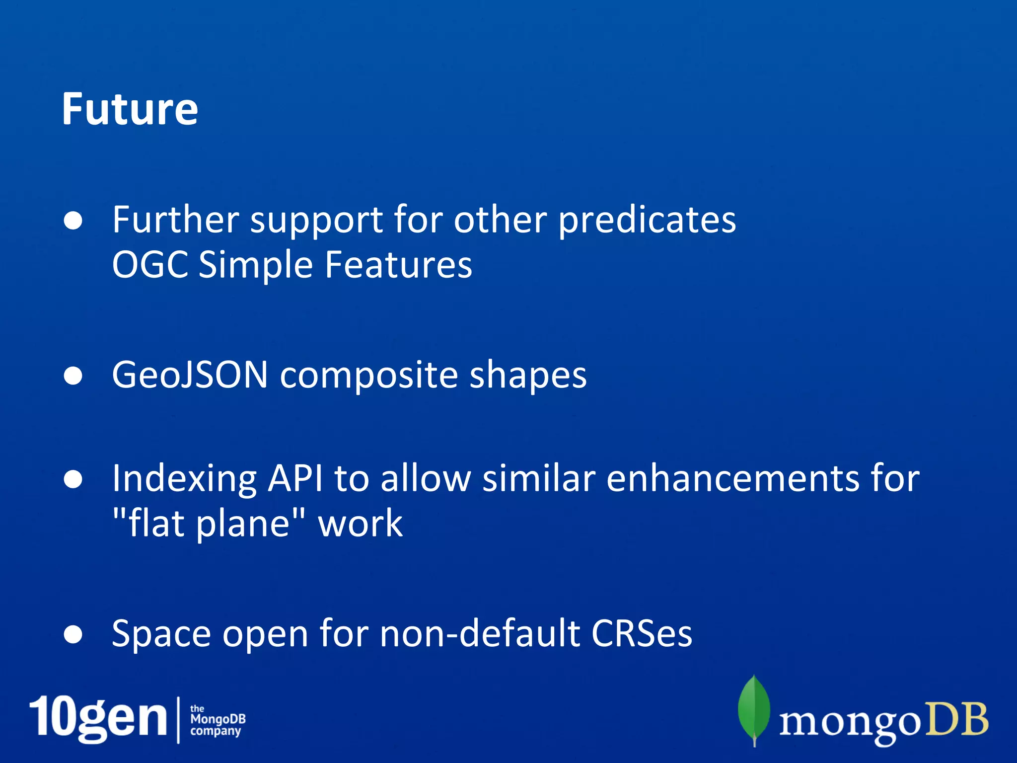


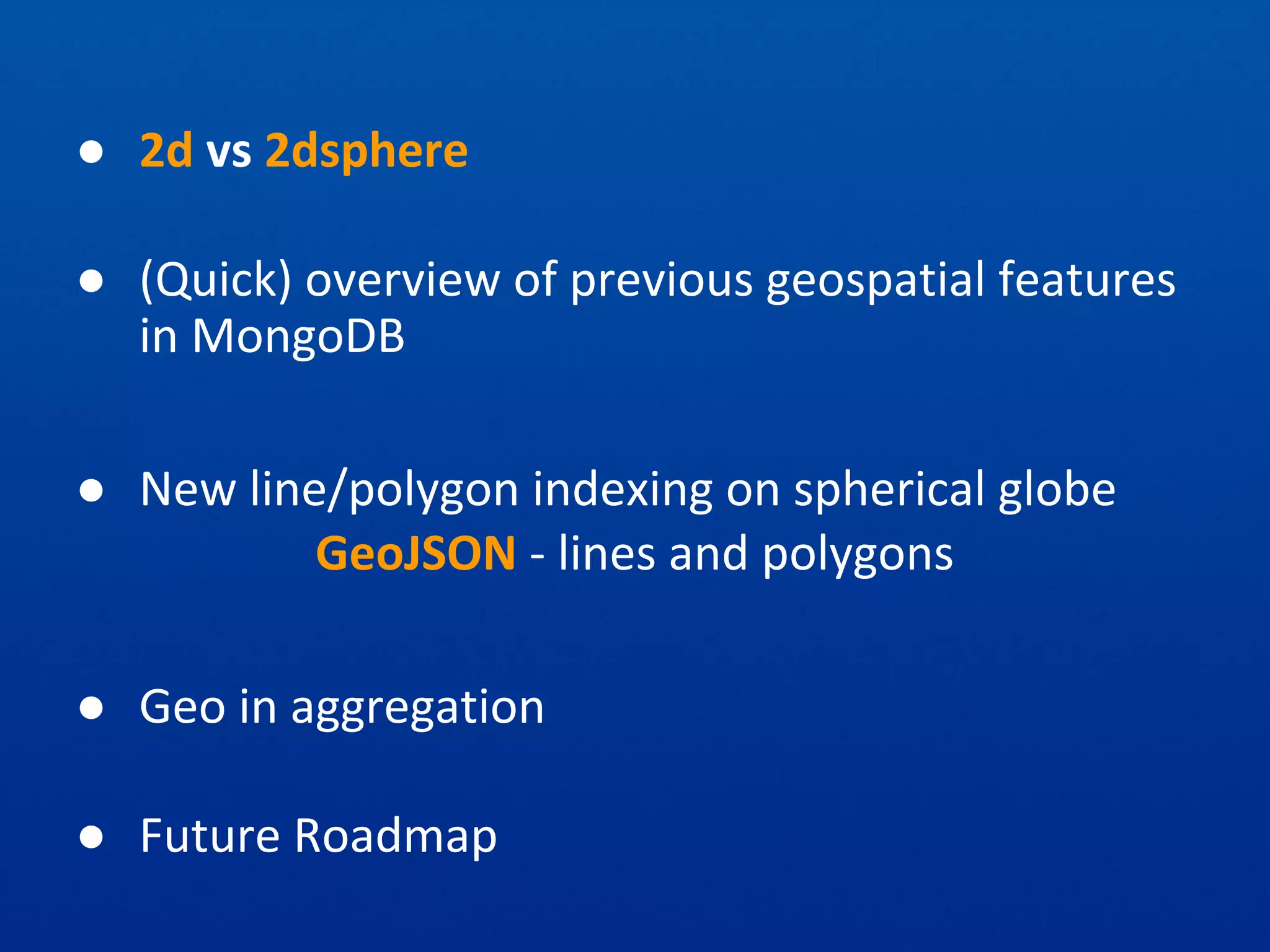
This document summarizes MongoDB's geospatial features including 2d and 2dsphere indexing, GeoJSON support for lines and polygons, and geospatial aggregation. It provides examples of querying points and geometries within regions, near points, and intersecting geometries. Future plans include additional geospatial predicates and indexing composite shapes.


![MongoDB .local San Francisco 2020: Powering the new age data demands [Infosys]](https://cdn.slidesharecdn.com/ss_thumbnails/315pminfosysfinalsfoversionvocalpart1-200120221508-thumbnail.jpg?width=600ounds&width=560&fit=bounds)


