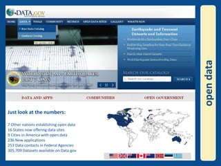
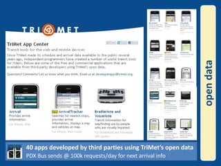
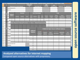
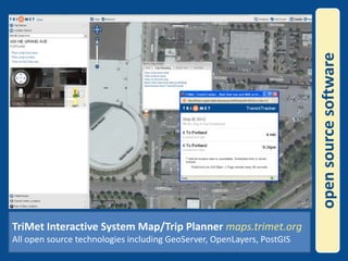
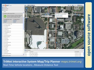
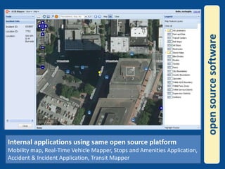
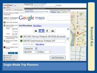
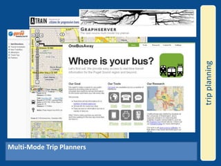
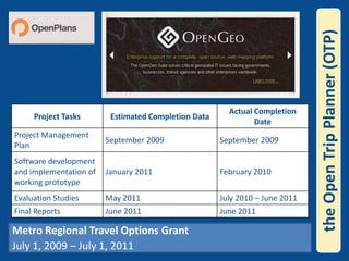
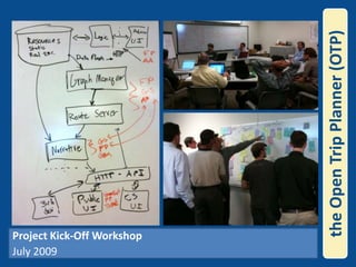
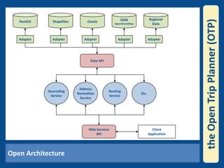
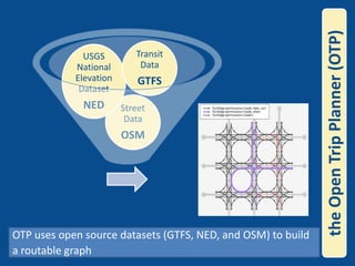
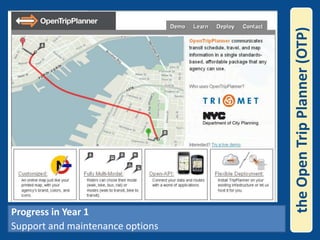
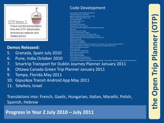
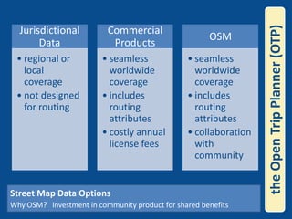
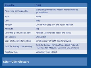
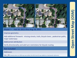
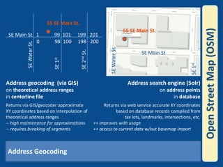
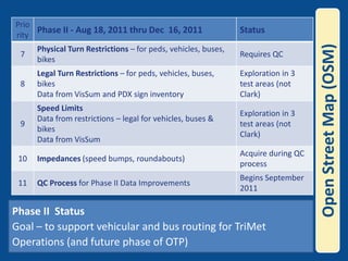
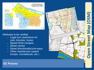
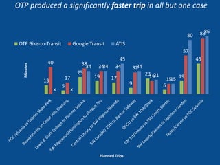
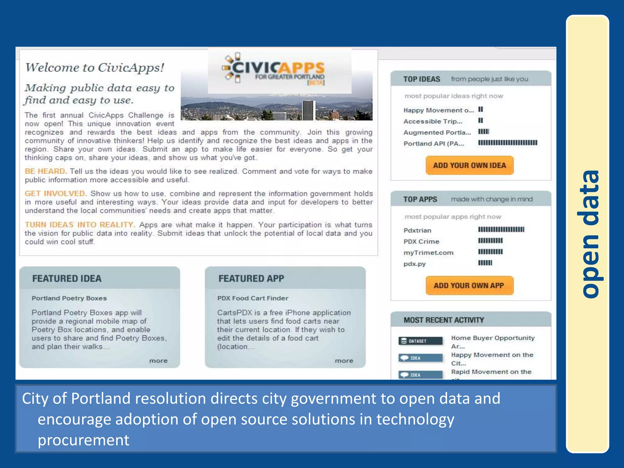
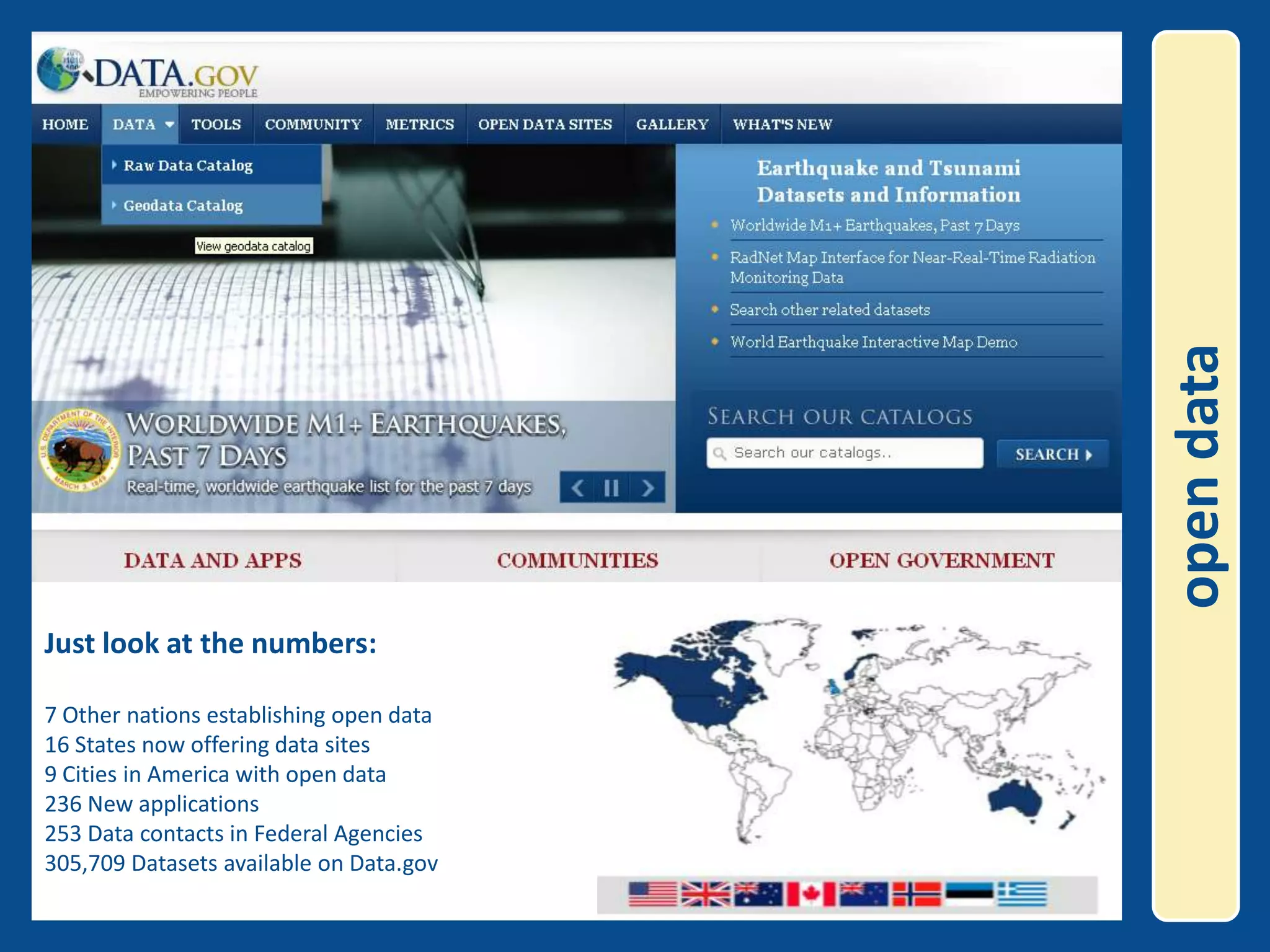
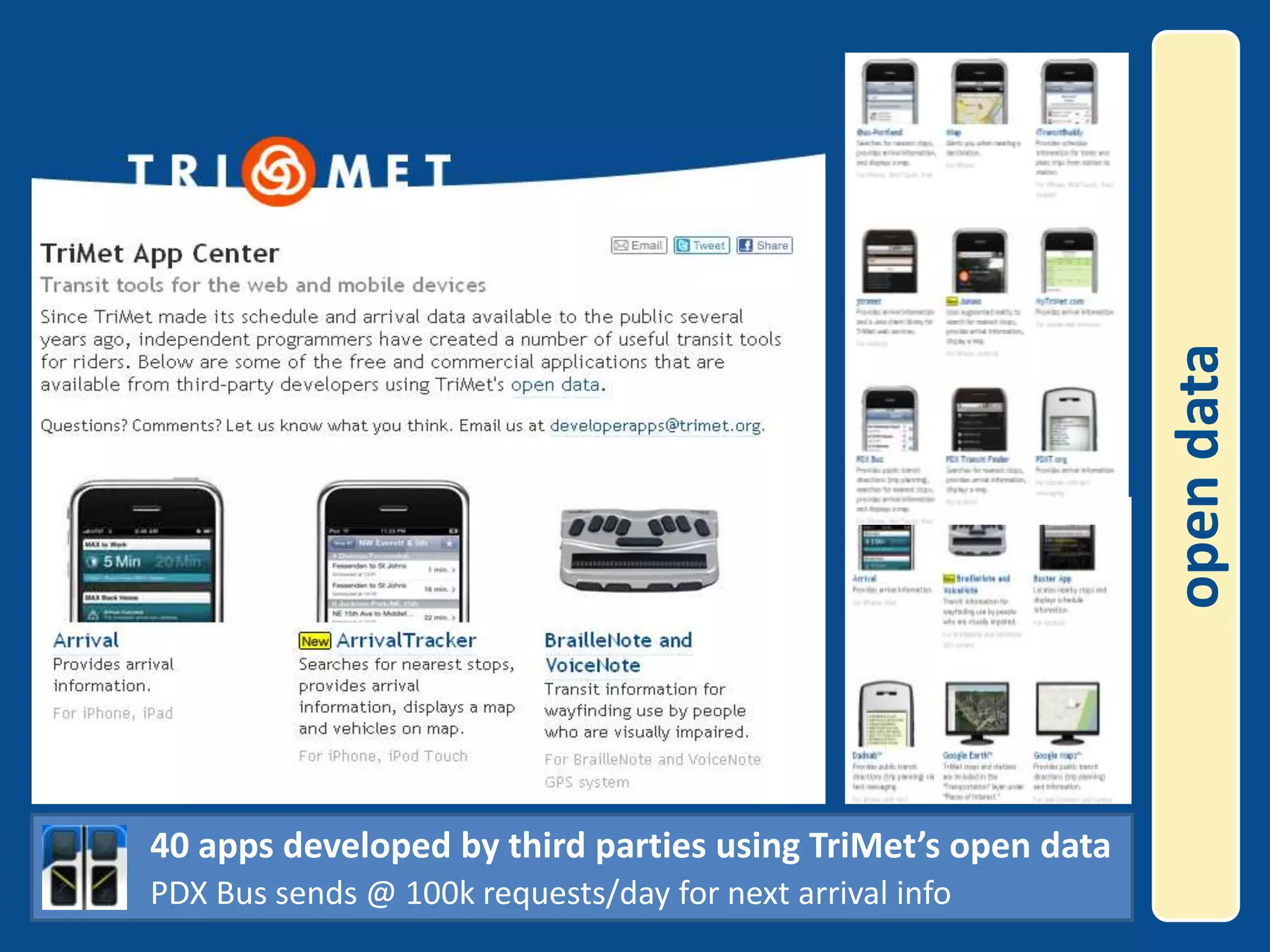
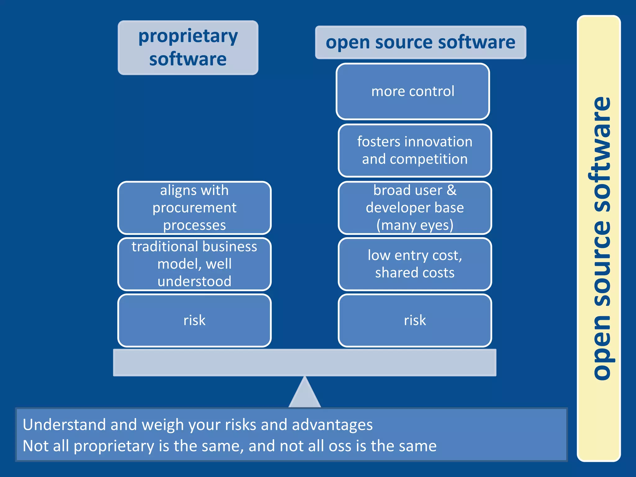
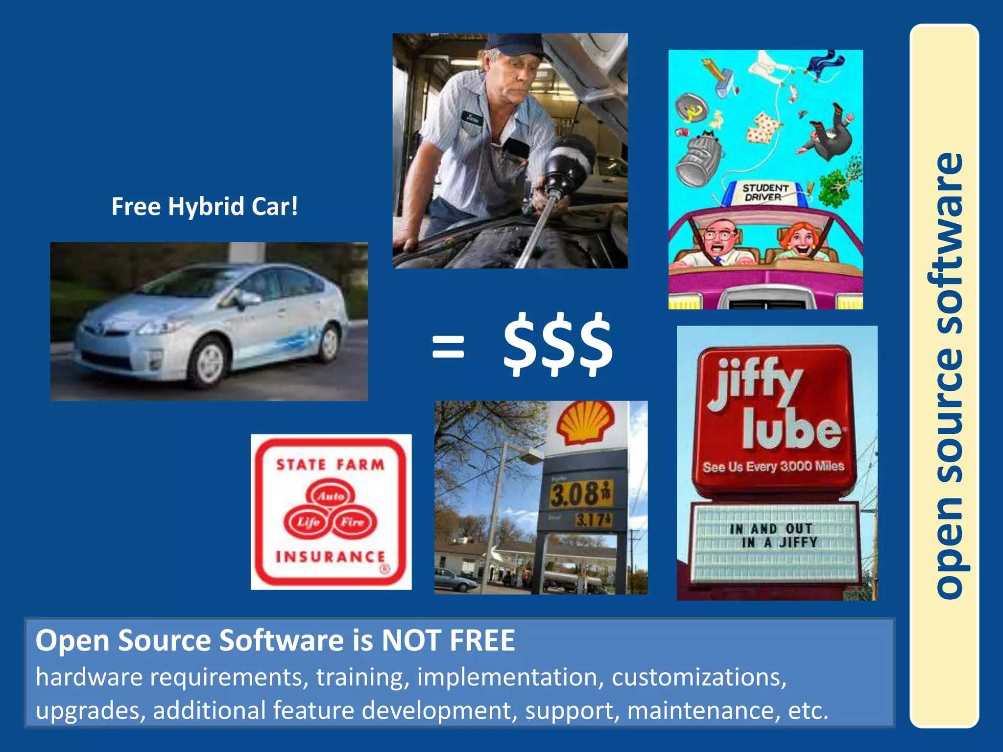
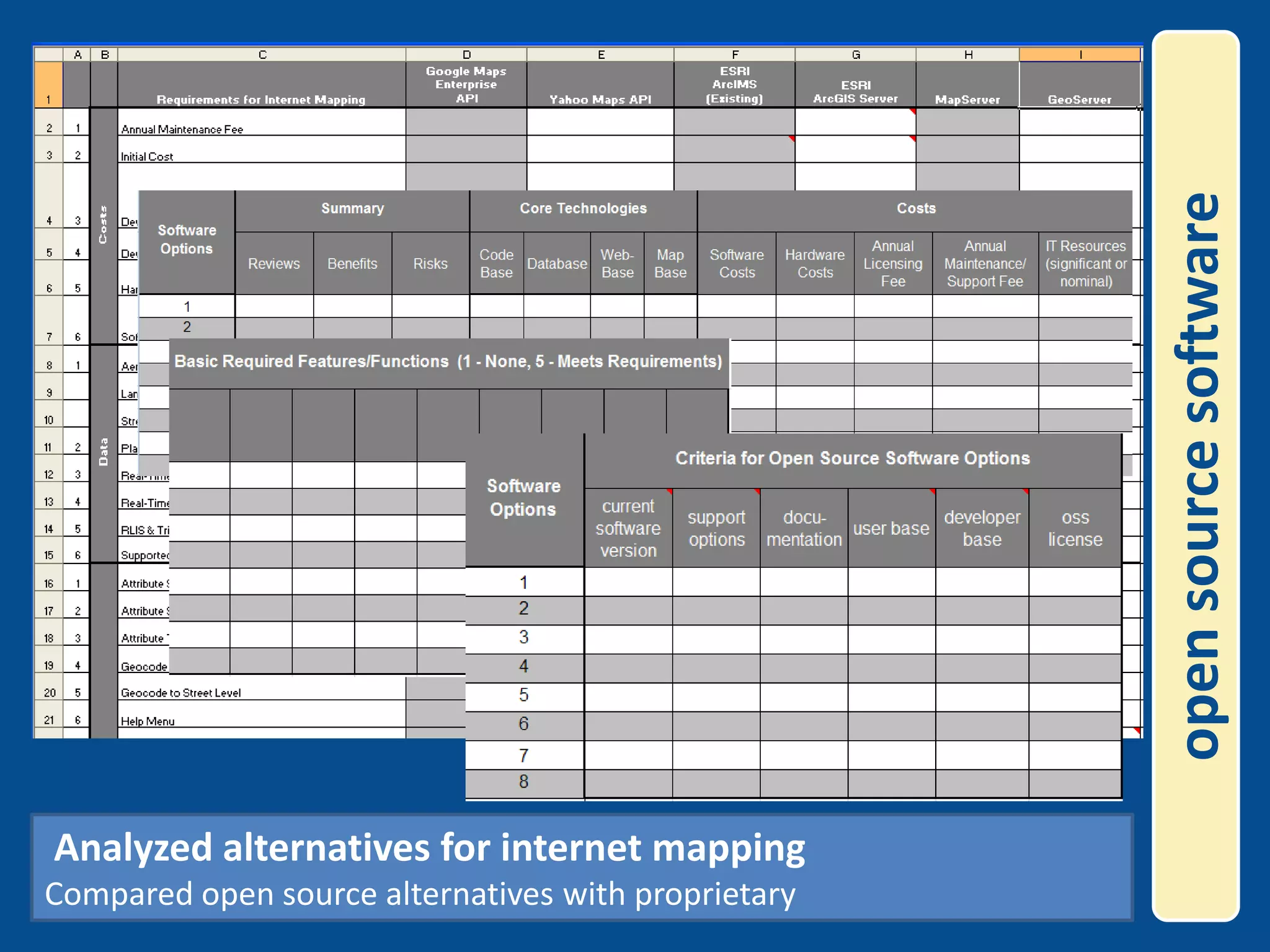
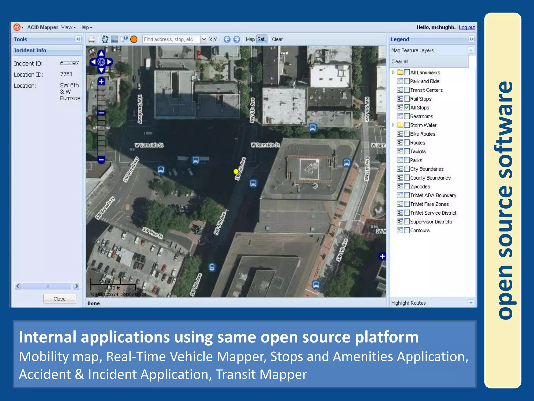
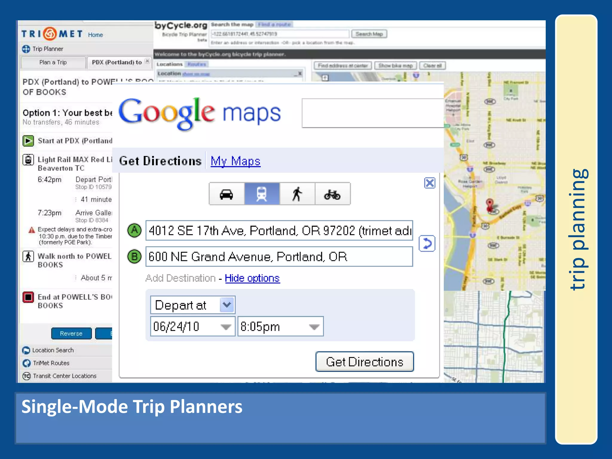
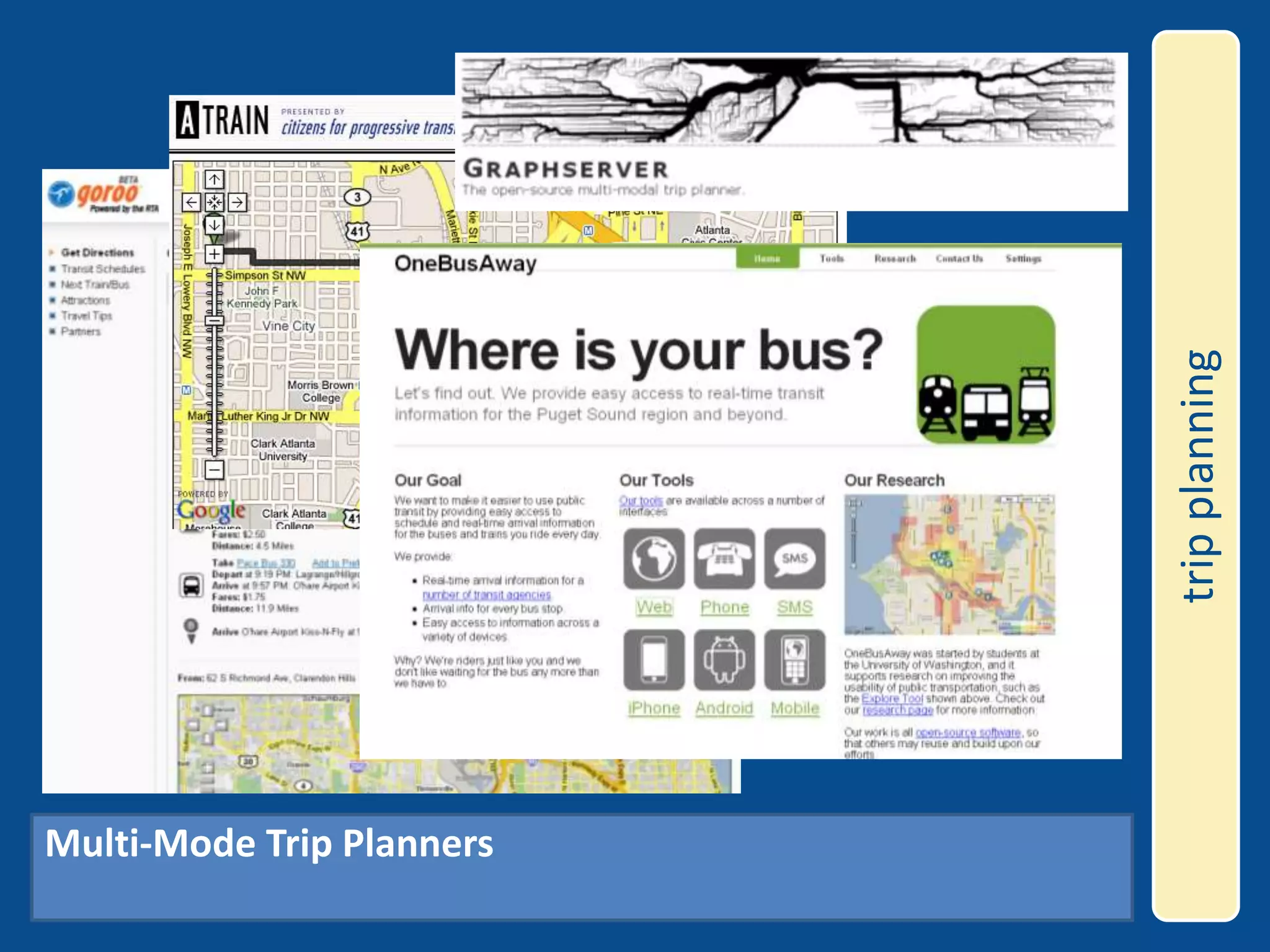
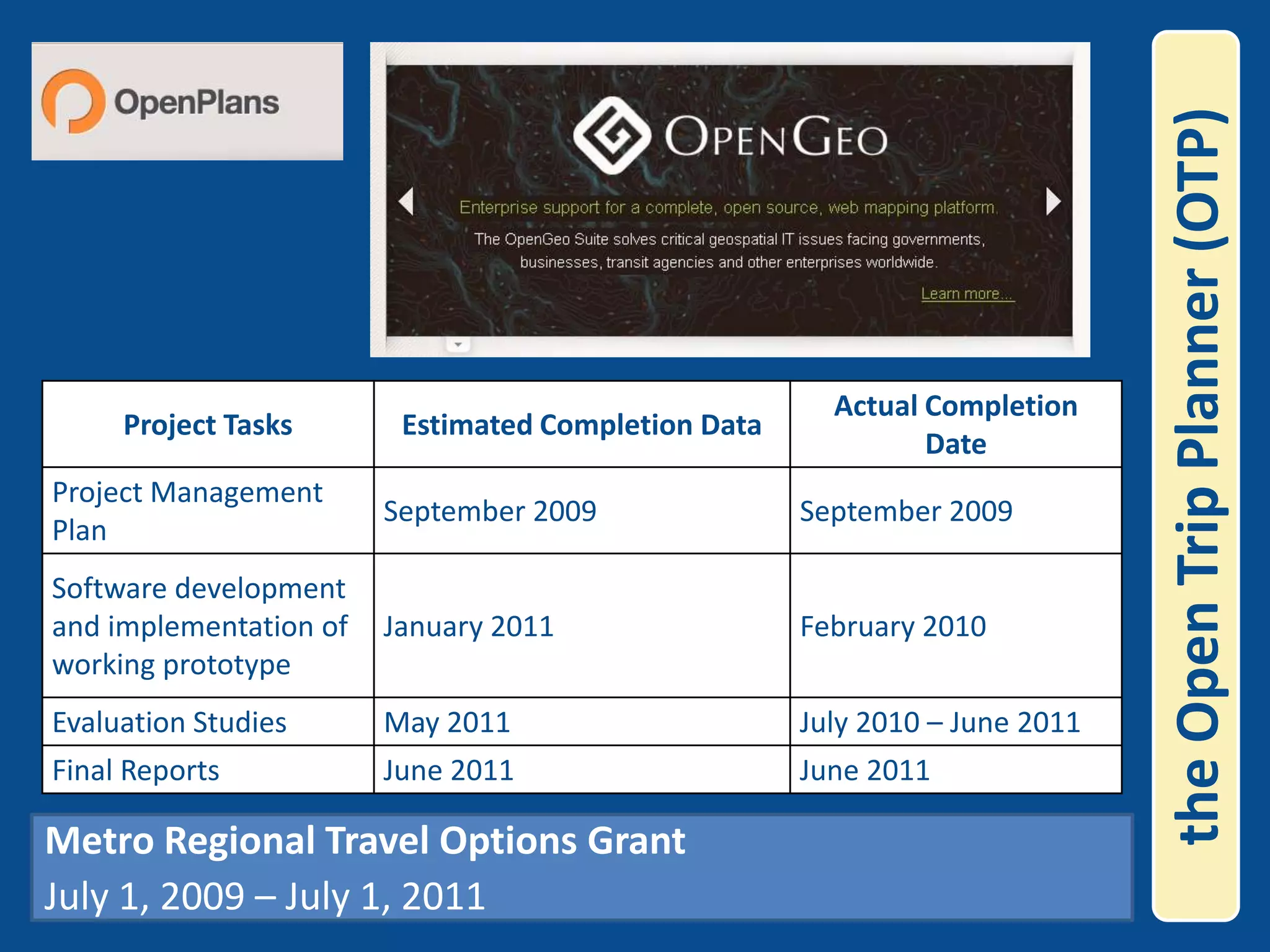
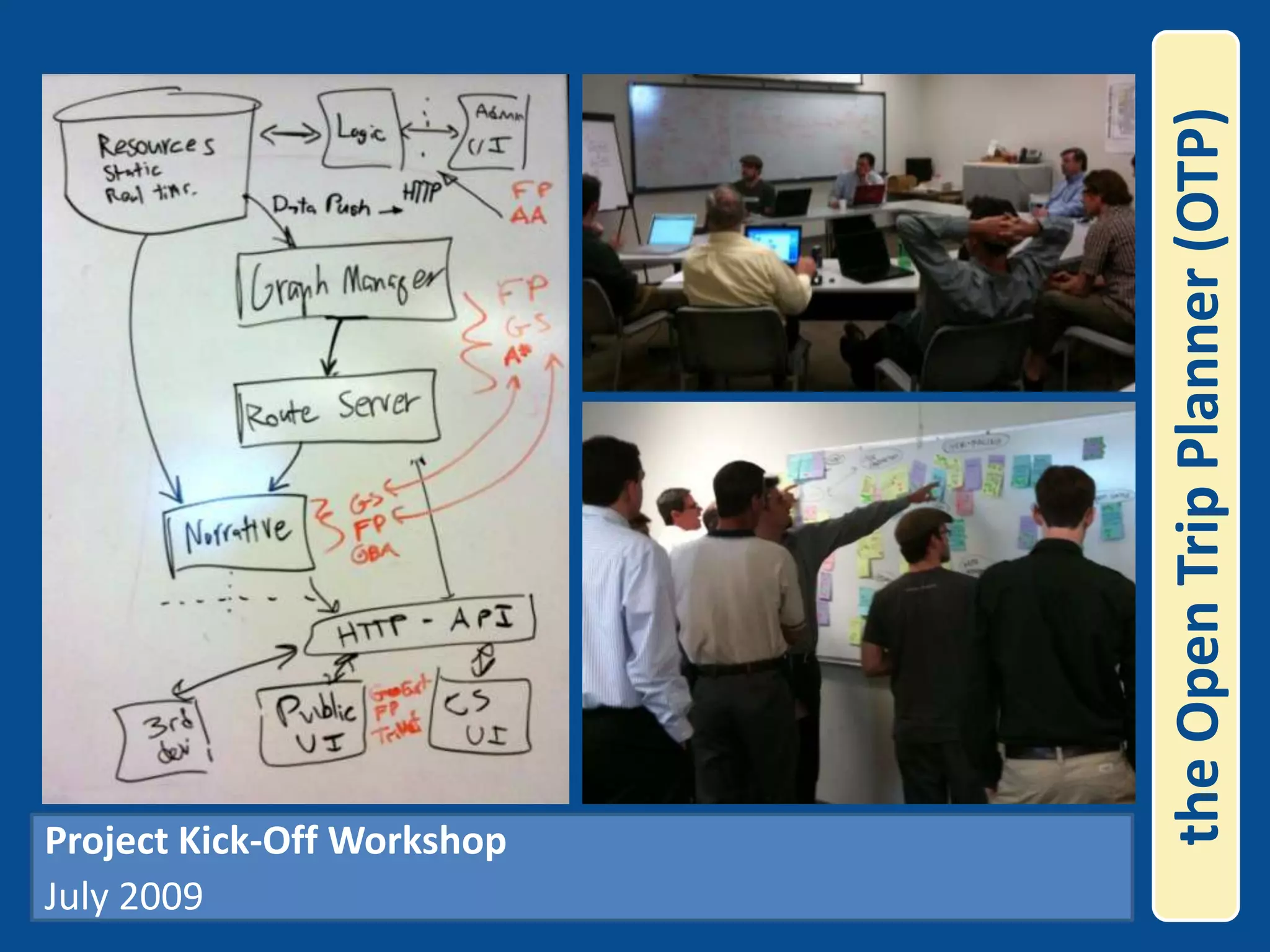
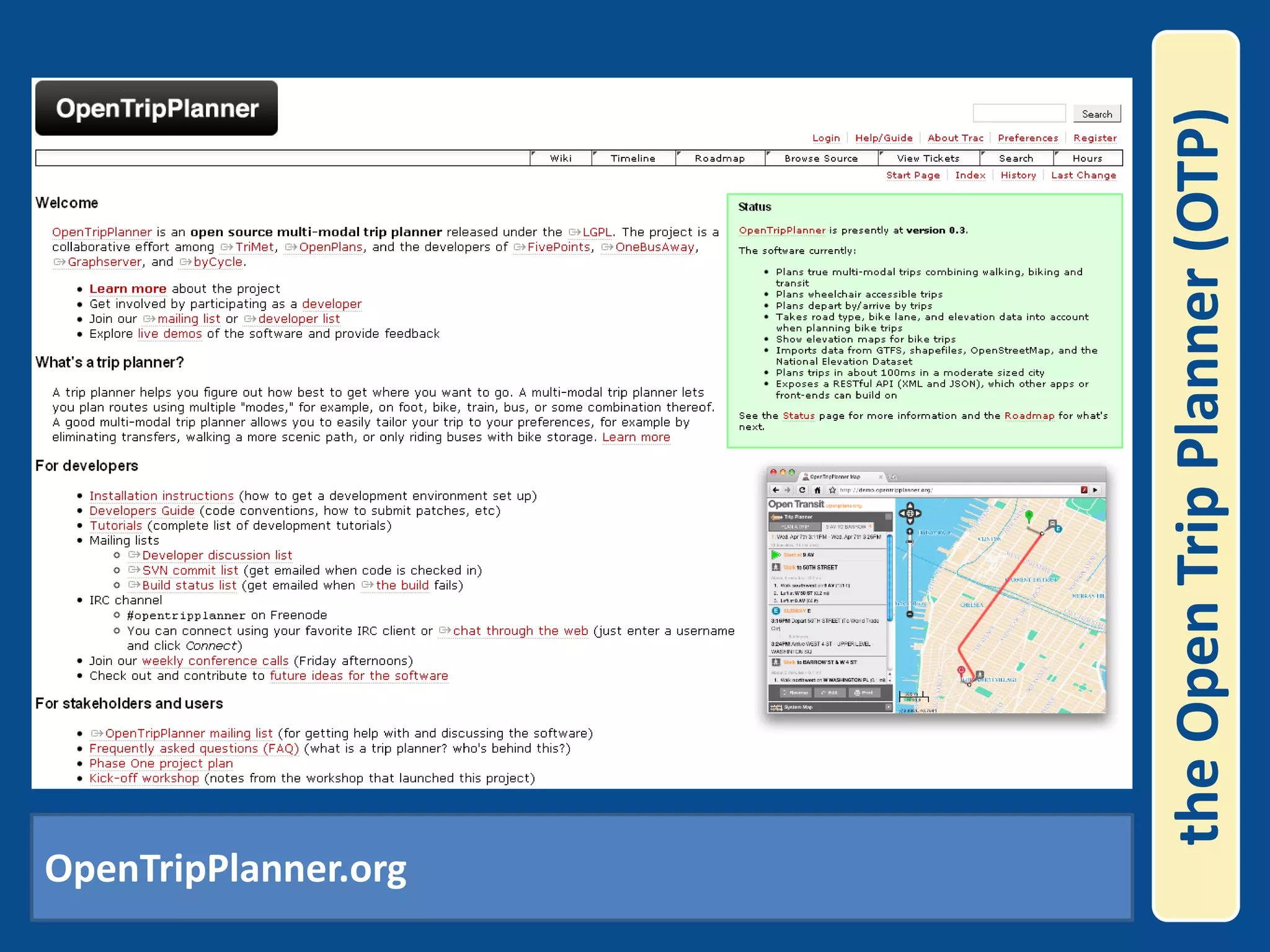
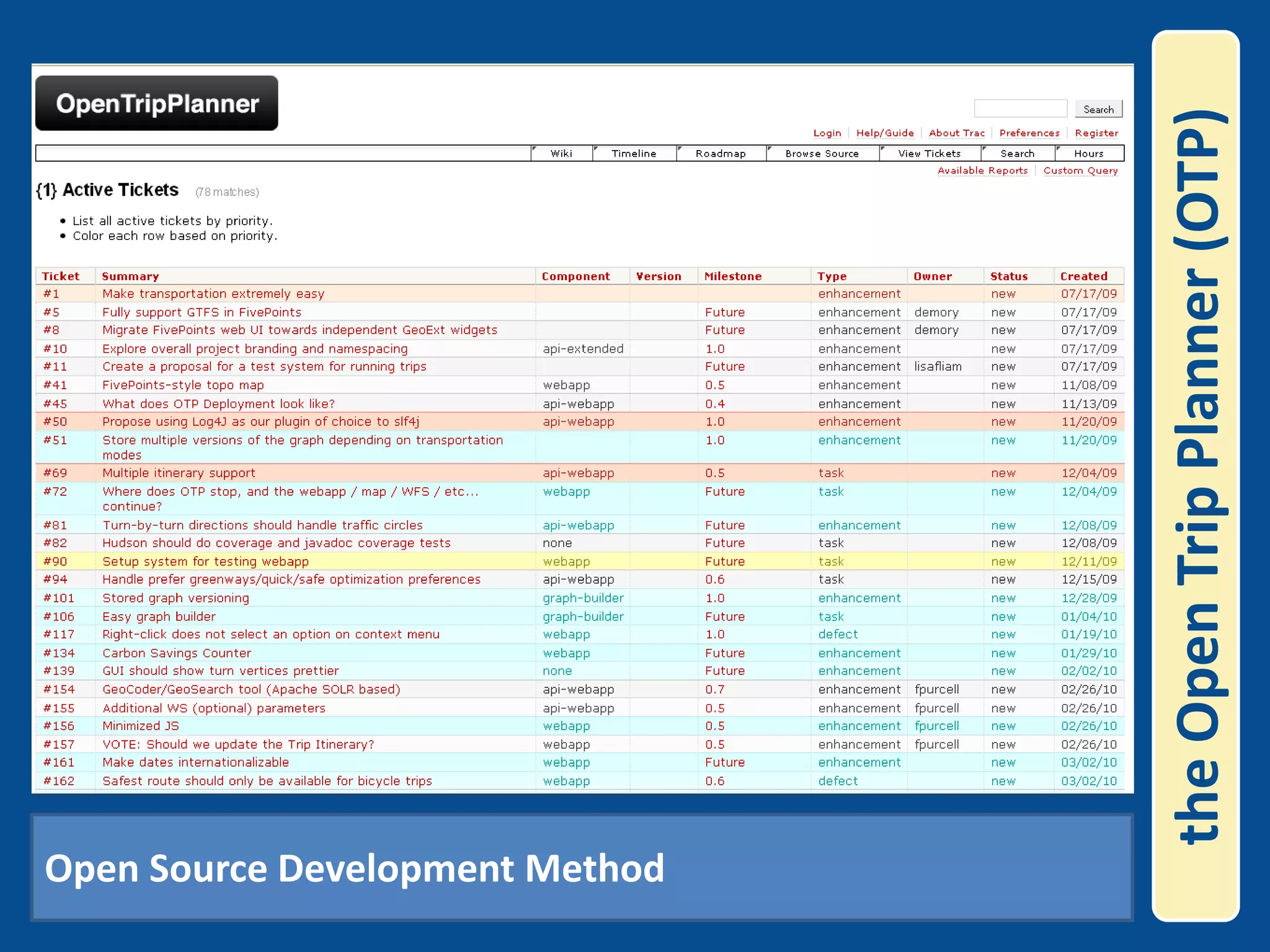
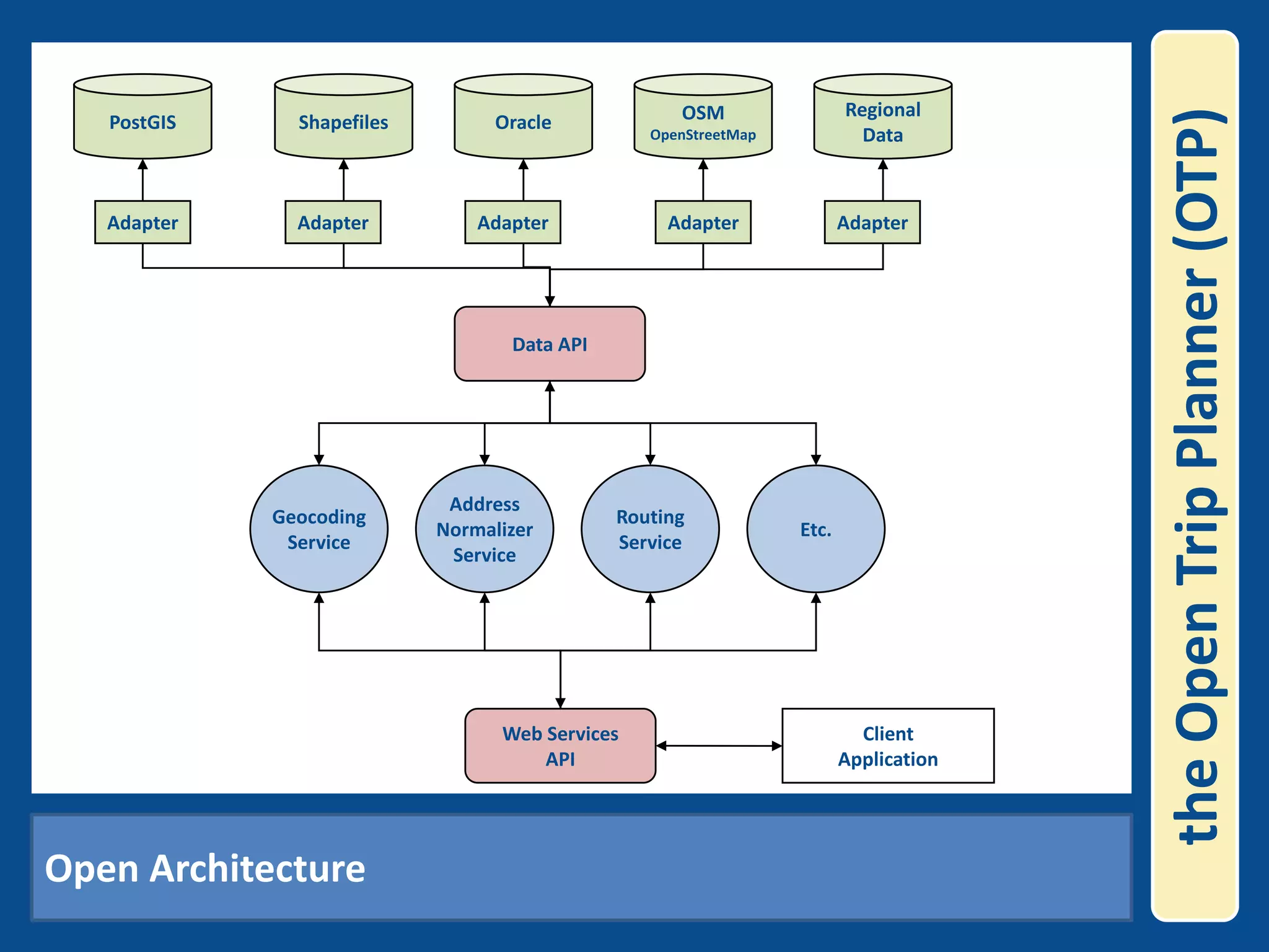
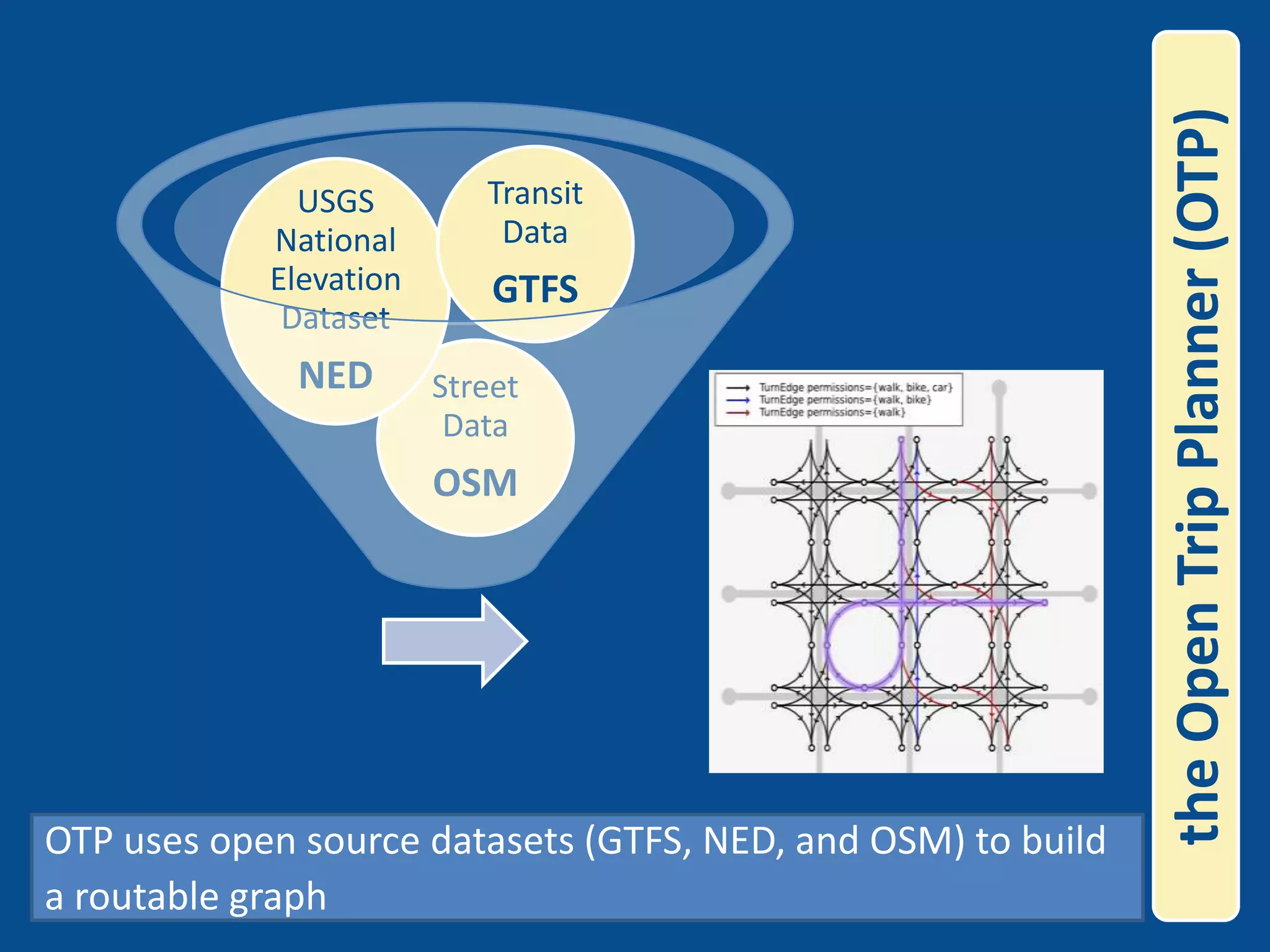
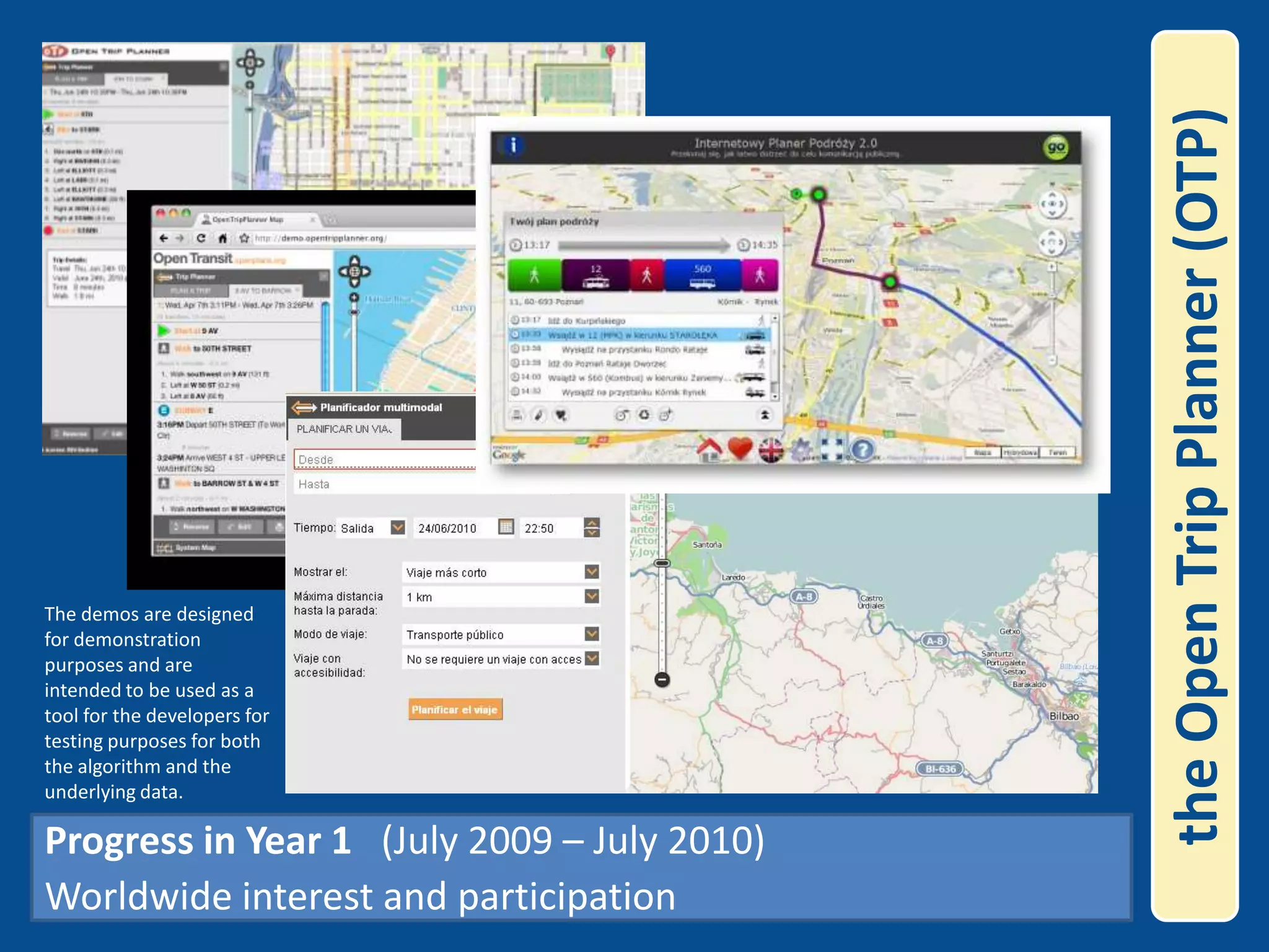
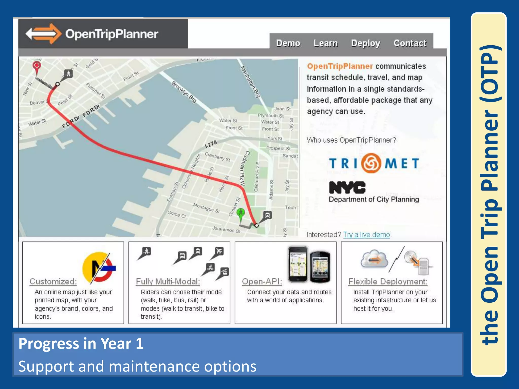
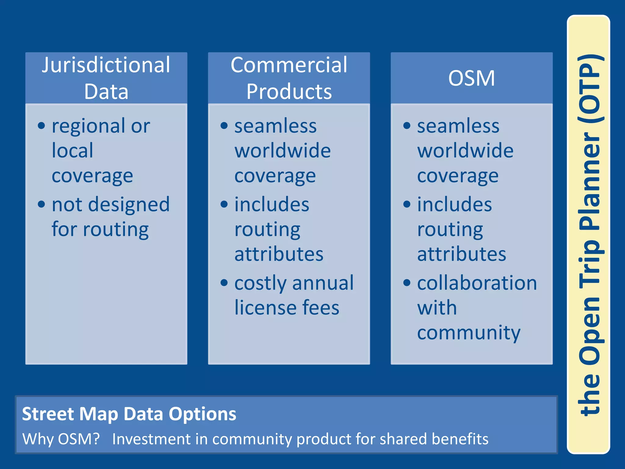
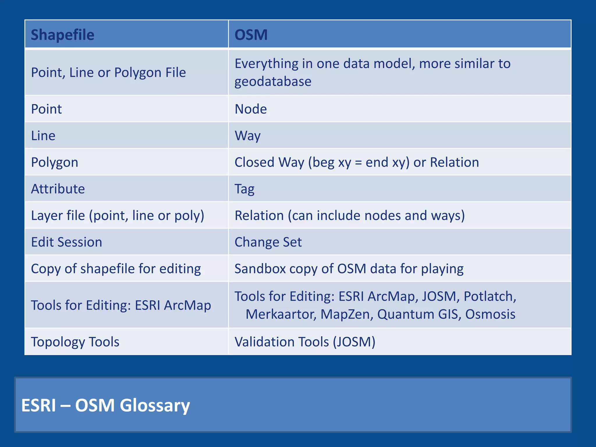
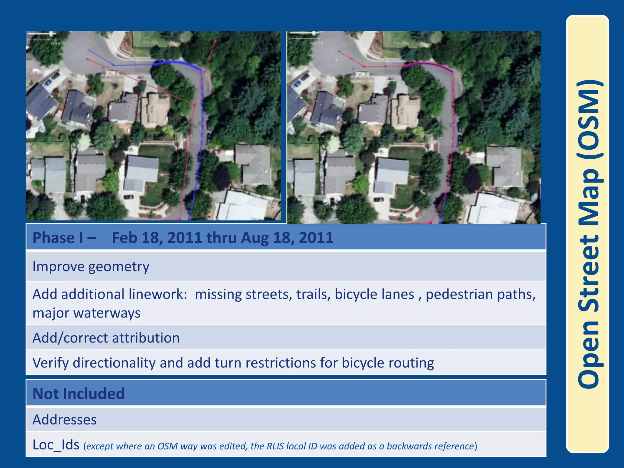
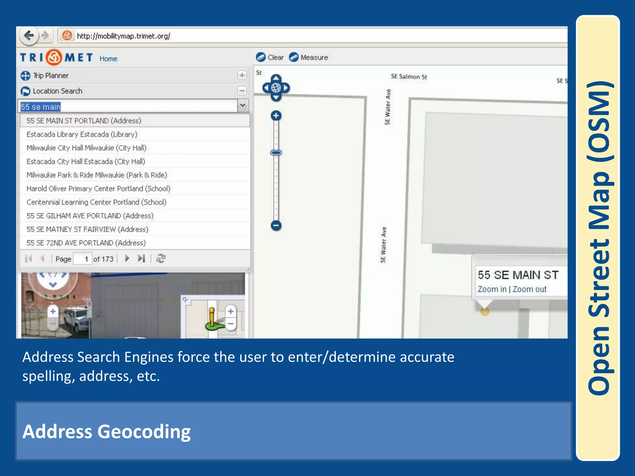
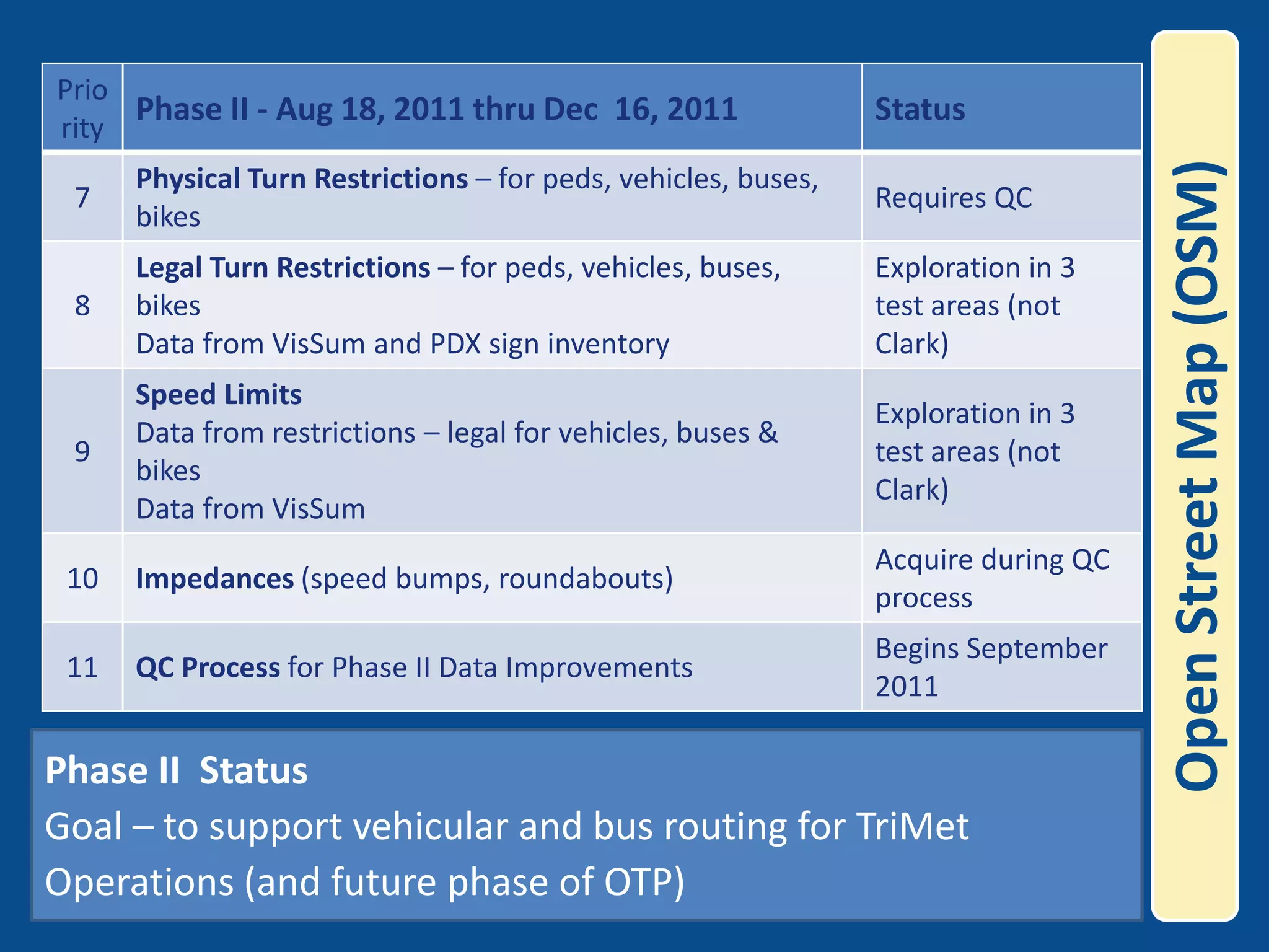
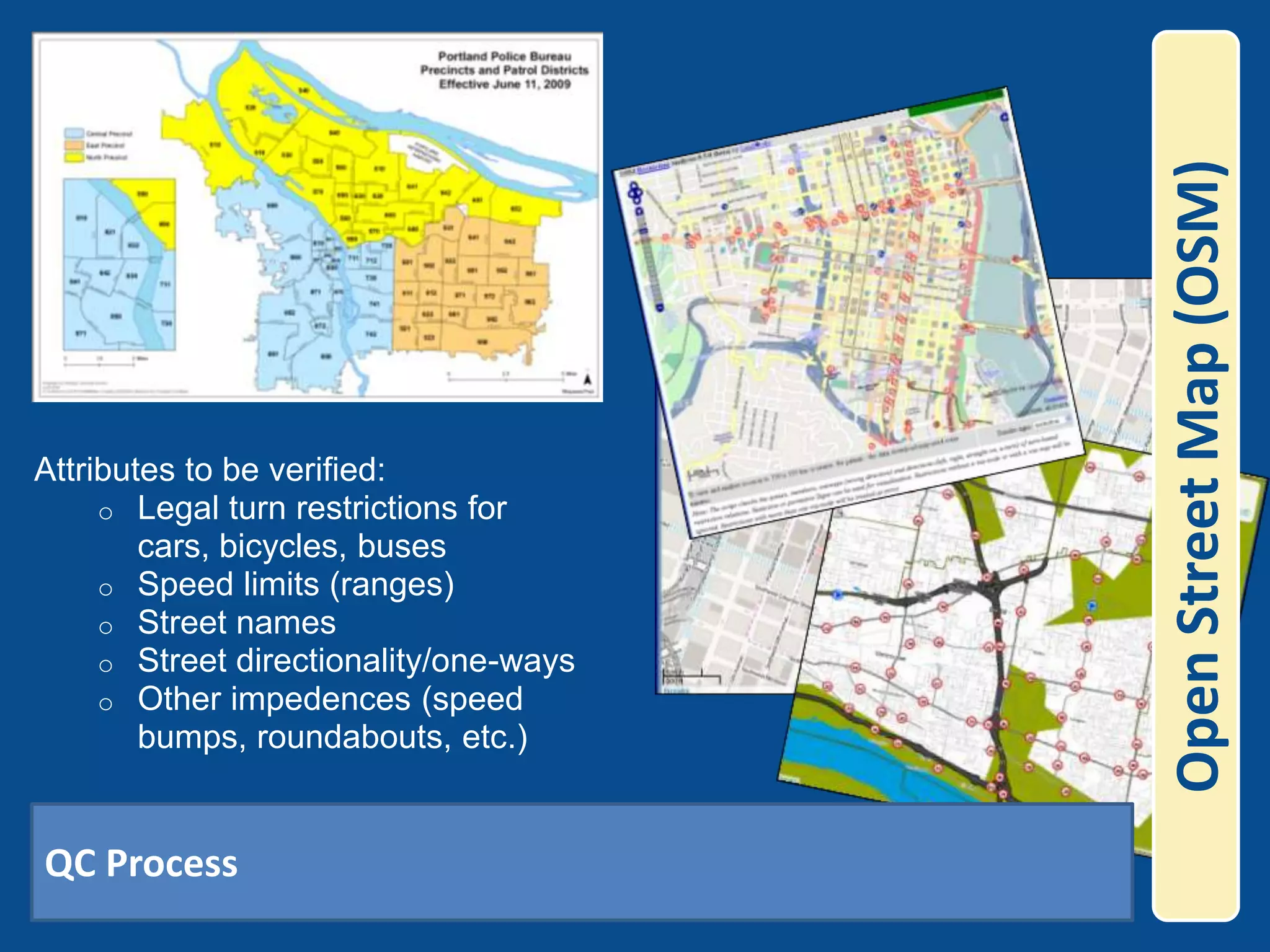
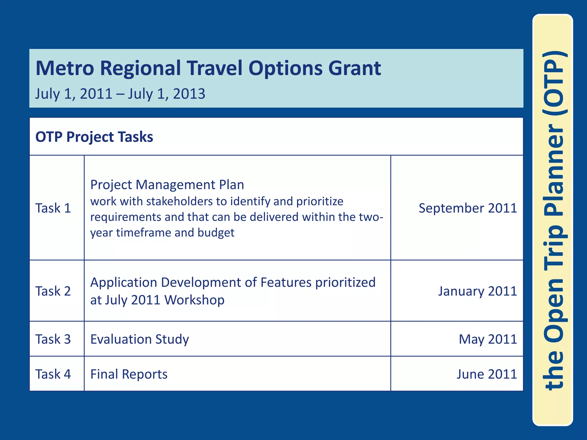
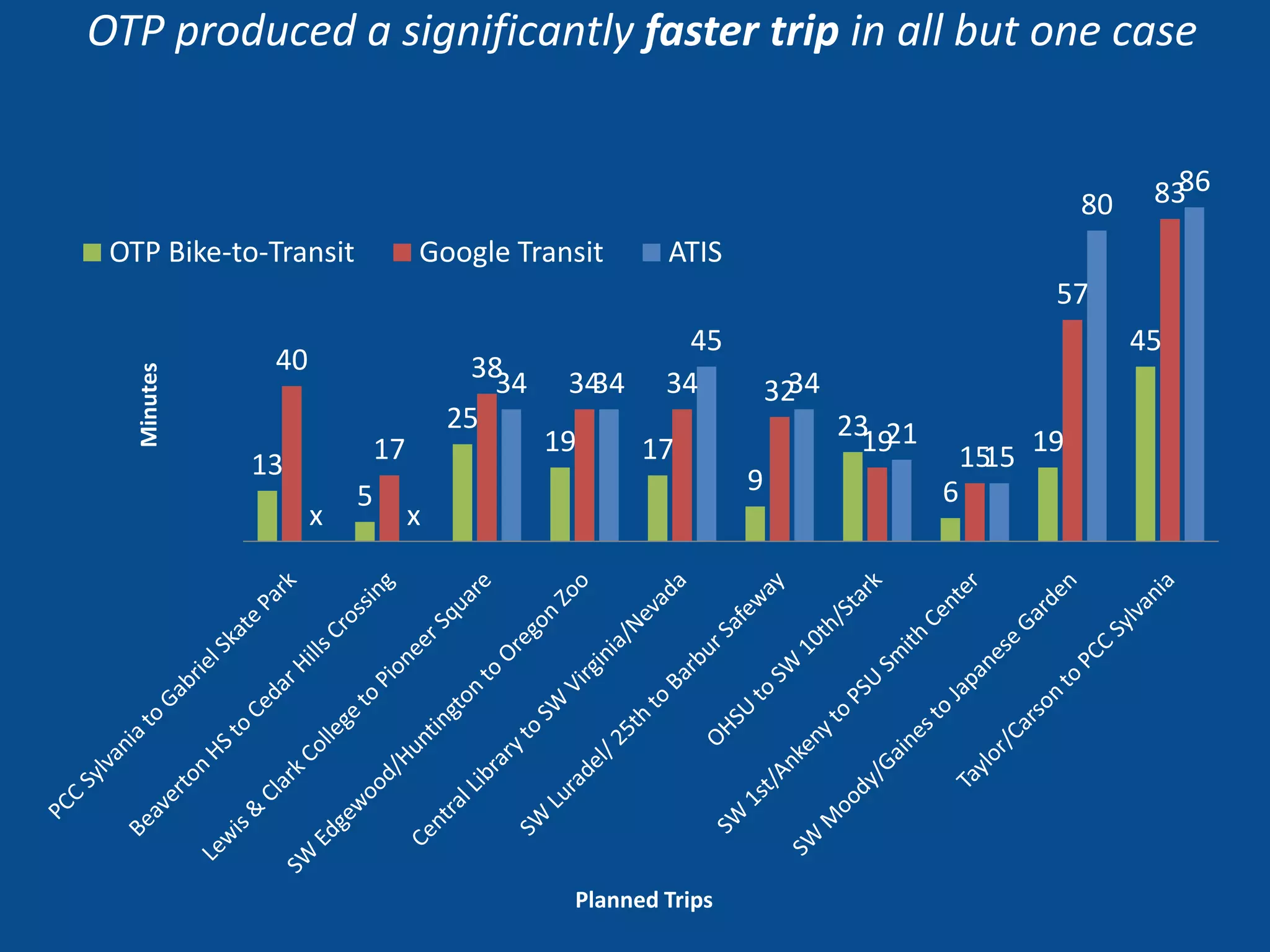
KEMBAR78
Na co gis comm 2011 | PPTX
Open Geo-Data and Open Geo-SoftwareNational Assoc. of CountiesGIS Subcommittee Agenda July 16, 2011 Presented by Bibiana McHughIT Manager of Spatial TechnologiesTriMet
open dataCity of Portland resolution directs city government to open data and encourage adoption of open source solutions in technology procurement
Just look at the numbers:7 Other nations establishing open data16 States now offering data sites9 Cities in America with open data236 New applications 253 Data contacts in Federal Agencies305,709 Datasets available on Data.govopen data
open data            40 apps developed by third parties using TriMet’s open dataPDX Bus sends @ 100k requests/day for next arrival info
open source softwareUnderstand and weigh your risks and advantagesNot all proprietary is the same, and not all oss is the same
open source software
=  $$$open source softwareFree Hybrid Car!Open Source Software is NOT FREEhardware requirements, training, implementation, customizations, upgrades, additional feature development, support, maintenance, etc.
open source software Analyzed alternatives for internet mappingCompared open source alternatives with proprietary
open source softwareTriMet Interactive System Map/Trip Planner maps.trimet.orgAll open source technologies including GeoServer, OpenLayers, PostGIS
open source softwareTriMet Interactive System Map/Trip Planner maps.trimet.orgReal-Time Vehicle locations , Measure Distance Tool
open source softwareInternal applications using same open source platformMobility map, Real-Time Vehicle Mapper, Stops and Amenities Application, Accident & Incident Application, Transit Mapper
trip planningSingle-Mode Trip Planners
trip planningMulti-Mode Trip Planners
trip planning2009 Portland, OR trimet trip planneroregon unemployment claim95.5 the gamemultnomah county jailonpoint credit unionmypccpcc.edupdx.eduworkinginoregon.orgblazers edge2010 Portland, OR
the Open Trip Planner (OTP)Metro Regional Travel Options Grant July 1, 2009 – July 1, 2011
the Open Trip Planner (OTP)Project Kick-Off Workshop July 2009
the Open Trip Planner (OTP)OpenTripPlanner.org
the Open Trip Planner (OTP)Open Source Development Method
the Open Trip Planner (OTP)ShapefilesOracleOSMOpenStreetMapRegionalDataPostGISAdapterAdapterAdapterAdapterAdapterData APIGeocodingServiceAddressNormalizerServiceEtc.RoutingServiceClientApplicationWeb ServicesAPIOpen Architecture
the Open Trip Planner (OTP)OTP uses open source datasets (GTFS, NED, and OSM) to build a routable graph
the Open Trip Planner (OTP)The demos are designed for demonstration purposes and are intended to be used as a tool for the developers for testing purposes for both the algorithm and the underlying data.  Progress in Year 1   (July 2009 – July 2010)Worldwide interest and participation
the Open Trip Planner (OTP)Progress in Year 1Support and maintenance options
Code DevelopmentCode quality and extensibility improvements Improved wheelchair accessibility graph reloading Speed improvements (~10x) Memory usage improvements (~0.5) Code documentation Intermediate stops in API Better extensibility Visualization improvements Making bikes on transit optional Kept up-to-date with changing technology (upgraded Spring) Edge notes Nominatimgeocoder support Cleaner max walk distance support Support for certain common GTFS failure modes Workarounds for OSM data issues (pedestrian islands) Support loading OSM from Protocol Buffers format & bz2 xml OSM future proofing OSM permission bug fixes Traffic circles / roundabouts Much improved transfer support (min transfer times; transfers now routed on walking network) Support for multiple route names on the same stop pattern (typically night buses) Dozens of miscellaneous bug fixes Gvsig visualization Documentation for graph builder Better names for some OSM ways Better slope visualization Slope override for bridges Some integration with OneBusAwayPreferred/dispreferred/banned routesTranslations from English into the following seven languages: French, Gaelic, Hungarian, Italian, Marathi, Polish, Spanish the Open Trip Planner (OTP)Demos Released:Granada, Spain July 2010Pune, India October 2010Smartrip Transport for Dublin Journey Planner January 2011Ottawa Canada Green Trip Planner January 2011Tampa, Florida May 2011Gipuzkoa Transit Android App May 2011TeleAviv, Israel Translations into: French, Gaelic, Hungarian, Italian, Marathi, Polish, Spanish, Hebrew Progress in Year 2 July 2010 – July 2011
the Open Trip Planner (OTP)Street Map Data Options  Why OSM?   Investment in community product for shared benefits
Open Street Map (OSM)Jurisdictional FormatOSM RoutableFormat
ESRI – OSM Glossary
Open Street Map (OSM)
Open Street Map (OSM) SE Water St.SE 1stSE 2nd St.  SE Main St   1            99  101     199   201                        098  100     198   20055 SE Main St. SE Water St.SE 1st55 SE Main St.SE Main St Address Geocoding
Open Street Map (OSM)Address Search Engines force the user to enter/determine accurate spelling, address, etc.  Address Geocoding
Open Street Map (OSM)Phase II  StatusGoal – to support vehicular and bus routing for TriMet Operations (and future phase of OTP)
Open Street Map (OSM)Attributes to be verified:Legal turn restrictions for cars, bicycles, buses
Speed limits (ranges)
Street names
Street directionality/one-ways
Other impedences (speed bumps, roundabouts, etc.)QC Process
the Open Trip Planner (OTP)Metro Regional Travel Options Grant July 1, 2011 – July 1, 2013

Na co gis comm 2011

  • 1.
    Open Geo-Data andOpen Geo-SoftwareNational Assoc. of CountiesGIS Subcommittee Agenda July 16, 2011 Presented by Bibiana McHughIT Manager of Spatial TechnologiesTriMet
  • 2.
    open dataCity ofPortland resolution directs city government to open data and encourage adoption of open source solutions in technology procurement
  • 3.
    Just look atthe numbers:7 Other nations establishing open data16 States now offering data sites9 Cities in America with open data236 New applications 253 Data contacts in Federal Agencies305,709 Datasets available on Data.govopen data
  • 4.
    open data 40 apps developed by third parties using TriMet’s open dataPDX Bus sends @ 100k requests/day for next arrival info
  • 5.
    open source softwareUnderstandand weigh your risks and advantagesNot all proprietary is the same, and not all oss is the same
  • 6.
  • 7.
    = $$$opensource softwareFree Hybrid Car!Open Source Software is NOT FREEhardware requirements, training, implementation, customizations, upgrades, additional feature development, support, maintenance, etc.
  • 8.
    open source softwareAnalyzed alternatives for internet mappingCompared open source alternatives with proprietary
  • 9.
    open source softwareTriMetInteractive System Map/Trip Planner maps.trimet.orgAll open source technologies including GeoServer, OpenLayers, PostGIS
  • 10.
    open source softwareTriMetInteractive System Map/Trip Planner maps.trimet.orgReal-Time Vehicle locations , Measure Distance Tool
  • 11.
    open source softwareInternalapplications using same open source platformMobility map, Real-Time Vehicle Mapper, Stops and Amenities Application, Accident & Incident Application, Transit Mapper
  • 12.
  • 13.
  • 14.
    trip planning2009 Portland,OR trimet trip planneroregon unemployment claim95.5 the gamemultnomah county jailonpoint credit unionmypccpcc.edupdx.eduworkinginoregon.orgblazers edge2010 Portland, OR
  • 15.
    the Open TripPlanner (OTP)Metro Regional Travel Options Grant July 1, 2009 – July 1, 2011
  • 16.
    the Open TripPlanner (OTP)Project Kick-Off Workshop July 2009
  • 17.
    the Open TripPlanner (OTP)OpenTripPlanner.org
  • 18.
    the Open TripPlanner (OTP)Open Source Development Method
  • 19.
    the Open TripPlanner (OTP)ShapefilesOracleOSMOpenStreetMapRegionalDataPostGISAdapterAdapterAdapterAdapterAdapterData APIGeocodingServiceAddressNormalizerServiceEtc.RoutingServiceClientApplicationWeb ServicesAPIOpen Architecture
  • 20.
    the Open TripPlanner (OTP)OTP uses open source datasets (GTFS, NED, and OSM) to build a routable graph
  • 21.
    the Open TripPlanner (OTP)The demos are designed for demonstration purposes and are intended to be used as a tool for the developers for testing purposes for both the algorithm and the underlying data. Progress in Year 1 (July 2009 – July 2010)Worldwide interest and participation
  • 22.
    the Open TripPlanner (OTP)Progress in Year 1Support and maintenance options
  • 23.
    Code DevelopmentCode qualityand extensibility improvements Improved wheelchair accessibility graph reloading Speed improvements (~10x) Memory usage improvements (~0.5) Code documentation Intermediate stops in API Better extensibility Visualization improvements Making bikes on transit optional Kept up-to-date with changing technology (upgraded Spring) Edge notes Nominatimgeocoder support Cleaner max walk distance support Support for certain common GTFS failure modes Workarounds for OSM data issues (pedestrian islands) Support loading OSM from Protocol Buffers format & bz2 xml OSM future proofing OSM permission bug fixes Traffic circles / roundabouts Much improved transfer support (min transfer times; transfers now routed on walking network) Support for multiple route names on the same stop pattern (typically night buses) Dozens of miscellaneous bug fixes Gvsig visualization Documentation for graph builder Better names for some OSM ways Better slope visualization Slope override for bridges Some integration with OneBusAwayPreferred/dispreferred/banned routesTranslations from English into the following seven languages: French, Gaelic, Hungarian, Italian, Marathi, Polish, Spanish the Open Trip Planner (OTP)Demos Released:Granada, Spain July 2010Pune, India October 2010Smartrip Transport for Dublin Journey Planner January 2011Ottawa Canada Green Trip Planner January 2011Tampa, Florida May 2011Gipuzkoa Transit Android App May 2011TeleAviv, Israel Translations into: French, Gaelic, Hungarian, Italian, Marathi, Polish, Spanish, Hebrew Progress in Year 2 July 2010 – July 2011
  • 24.
    the Open TripPlanner (OTP)Street Map Data Options Why OSM? Investment in community product for shared benefits
  • 25.
    Open Street Map(OSM)Jurisdictional FormatOSM RoutableFormat
  • 26.
    ESRI – OSMGlossary
  • 27.
  • 28.
    Open Street Map(OSM) SE Water St.SE 1stSE 2nd St. SE Main St 1 99 101 199 201 098 100 198 20055 SE Main St. SE Water St.SE 1st55 SE Main St.SE Main St Address Geocoding
  • 29.
    Open Street Map(OSM)Address Search Engines force the user to enter/determine accurate spelling, address, etc. Address Geocoding
  • 30.
    Open Street Map(OSM)Phase II StatusGoal – to support vehicular and bus routing for TriMet Operations (and future phase of OTP)
  • 31.
    Open Street Map(OSM)Attributes to be verified:Legal turn restrictions for cars, bicycles, buses
  • 32.
  • 33.
  • 34.
  • 35.
    Other impedences (speedbumps, roundabouts, etc.)QC Process
  • 36.
    the Open TripPlanner (OTP)Metro Regional Travel Options Grant July 1, 2011 – July 1, 2013
  • 37.
    the Open TripPlanner (OTP)On the Horizon
  • 38.
    the Open TripPlanner (OTP)OTP Interface Preview – Fall Beta Release
  • 39.
    OTP produced asignificantly faster trip in all but one caseMinutesPlanned Trips

Editor's Notes

  • #2 TriMet is the public transportation service provider in Portland, OR
  • #3 City of Portland resolution directs the city government to open data to outside developers and encourages adoption of open source solutions in technology procurement1. Made as much data available on civicapps – very quickly2. Solicited ideas for applications and voting mechanism2. Held 2 app contests requiring that winning app must be open source
  • #4 Data.gov is a leading example in the open data movement. We were excited about it because it aligns with our moded. Because software development is not the government’s core business,is becoming a new role government – to make public data publicly available and easy to access and use. Software development is not our core business.Developers want RAW digital data and a CATALOG so they can quickly understand what it is they’re working with.
  • #5 The results?  Lots of satisfied customers. We are nearing 40 applications all developed by third parties. Criteria for listing on apps page: Must be using our developer resourcesMust work as it says it doesMust adhere to our Terms of Use so that its clear to the user that the data comes from TriMet but the app is not. Our experience indicates that there is a natural selection process after the initial enthusiasm of an open data release, esp. surrounded by app contests. The good apps get better, and the bad apps are weeded out, which is good.
  • #6 In any IT procurement, we make an effort to look for open source alternatives, and we weigh the risks and advantages against the commercial options. Both have risks, however, open source has the potential for great benefits, esp. for government agencies, as we’re not in competition with each other.
  • #9 We developed a method fo comparing COTS with OSS. We performed an alternatives analysis a couple years ago and looked at commercial off-the-shelf products, free APIs (Google, Yahoo), and open source software like GeoServer and MapServer.  We’re a Java shop so GeoServer complied with all our IT standards, and it fit all of our requirements - both internal agency mapping needs and external customer mapping needs.  Again, my biggest hesitation was support for this product, however, I would say its actually superior. We’ve gotten responses/support from users/developers all over the world. Its amazing. Include Open Source Solutions in Feasibility Studies and Requirement Analysis (in addition to COTS)OS Code/Language – ex. can it be supported and maintained internally, does it adhere to IT standards Developer Base Working Implementations Terms and conditions of the OS license agreement Governance or Foundation Options for support and maintenance contracts No initial fee for the software, however, should calculate and compare long-term operating costs and resources against COTS
  • #10 Maps.trimet.org is powered by all open source technologies, including the OpenGeo Stack:  GeoServer, OpenLayers, and PostGIS.  Its all OGC standards compliant and we’ve been extremely happy with the sophistication of this technology and the level of world-wide support from the development community (and esp. from Open Plans). We wanted the ability to bring information from a variety of sources into one application so that customers can make informed decisions. We’re bringing in streetview, next arrival info, trip planning itineraries, stops and amenity information directly from out database.System Maps have historically been paper, but as soon you print, they’re out of date. The biggest advantage is its always up-to-date with little overhead and maintenance.
  • #11 Real-Time vehicle locations and the measure distance tool.We paid for it once, and not its in the source-code for the benefit of everyone. This is a great model for government – shared resources.
  • #12 It has also replaced all of our map object applications. Once the infrastructure is in place, its very easy to customize apps for a particular business use.
  • #13 Even though our map is pretty, and sophisticated, it is single mode only.
  • #16 Open Plans has experience developing communities around open source software and data. The objective is build a development community around the code and have Open Plans manage it so it’s a very viable alternative for agencies. 
  • #17 collaborative method to software design, development, distribution with access to source code
  • #19 Collaborative method of tracking work and voting on important decisions.
  • #26 Research is valuable, but there is no replacement for getting in there and actually editingExplain the images (the first one is what I thought the data should look like when I began and the second is what I learned it should be through observing others work)OSM users contacted us and (politely) informed us of things that we were doing incorrectlyShare what you have learned through editing with your team
  • #33 Project timeline July 2009- July 2011. TriMet received a grant to build an osmmtps.  The Open Planning Project (TOPP) http://topp.openplans.org/ is the primary contractor and the subs are David Emory/Five Points http://trip.atltransit.com/, Brandon Martin Anderson/GraphServer (Bus Monster) http://graphserver.sourceforge.net/, and TriMet (in-kind).  We're starting with David's code and building from there.  The objective is build a development community around the code and have TOPP/OpenGeo manage it so it’s a very viable alternative for agencies.  We have enough funding, but we need one other agency on board so its a collaborative effort to ensure continued success. In TOPP’s experience, the most successful os projects are collaborations, so this is critical. 
  • #36 Talk about how the trips with no green bars represent trips where ATIS could not plan – limitations of the single mode trip planner. ANY QUESTIONS
  • #37 And now I believe they are the fundamental building blocks for the next generation of GIS. And with everything open, anything is possible. Thank you.