Downloaded 23 times

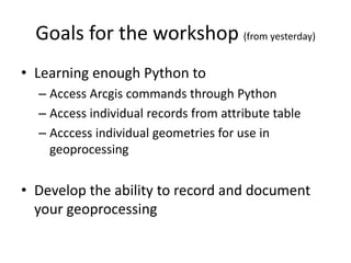

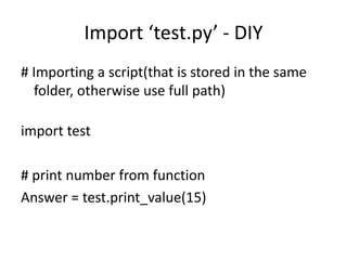
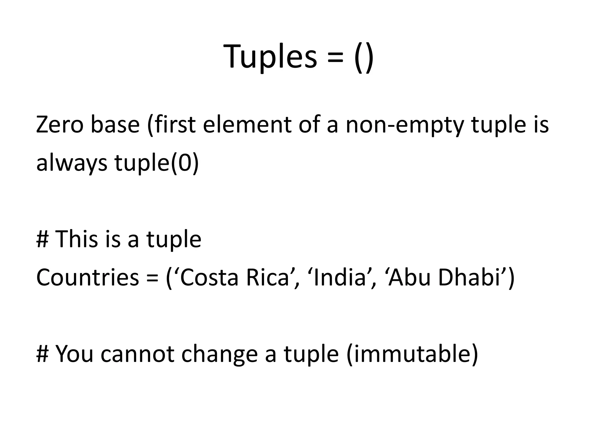
![Lists = []
An ordered set of elements enclosed in square brackets.
Zero based (first element is accessed by typing list[0]).
# This is a list []
animals = [ 'dog ' , ' cat ' , 'horse ' , ' seal ' ]
print animals[3]
animals.append(‘owl’)
Lists are mutable](https://image.slidesharecdn.com/pythonprogrammingforarcgis2-160424035012/85/Python-Programming-for-ArcGIS-Part-II-5-320.jpg)

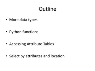
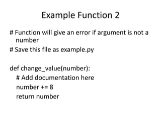
![String processing – slicing a string
# slicing a string
Name = ‘Massachusetts’
#Fenceposts – starting at index 1 and ending
# before index 2
Name[1:2]
# find the first 4 characters of Name
Name[:4]](https://image.slidesharecdn.com/pythonprogrammingforarcgis2-160424035012/85/Python-Programming-for-ArcGIS-Part-II-7-320.jpg)
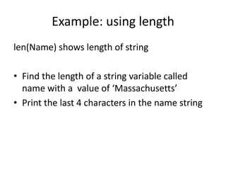
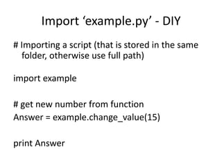

![Accessing the Attribute Table
def sumUpLength(shapefile):
# returns the length of all line segments in an attribute
table
import arcpy, os
sumLength = 0.0
try:
with arcpy.da.SearchCursor(shapefile, (“LENGTH”))
as cursor:
for row in cursor:
sumLength += row[0]
del cursor
except:
return -9999
return sumLength](https://image.slidesharecdn.com/pythonprogrammingforarcgis2-160424035012/85/Python-Programming-for-ArcGIS-Part-II-15-320.jpg)
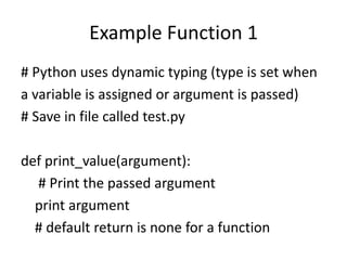
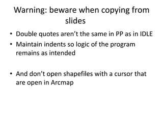
![Exercise 3 - cursor
We are working with a shapefile, stepping
through the atttribute table of a FEATURE
CLASS with the cursor:
FC =
"C:UsersdsheehanDesktopkenyaDistrict2.shp
"
with arcpy.da.SearchCursor(FC, ("DISTRICT")) as cursor:
for row in cursor:
print row[0]
del cursor](https://image.slidesharecdn.com/pythonprogrammingforarcgis2-160424035012/85/Python-Programming-for-ArcGIS-Part-II-18-320.jpg)
![Exercise 3 – selecting using attributes
Selecting by layer requires converting from a FEATURE CLASS to
LAYER but uses the same shapefile but opened a second time.
before loop
arcpy.MakeFeatureLayer_management("C:Usersdsheehan
DesktopkenyaDistricts.shp", "lyr")
Inside loop
arcpy.SelectLayerByAttribute_management("lyr",
"NEW_SELECTION", ' "DISTRICT" = '' + row[0] + ''')
Confused by mix of quotes, single and double?](https://image.slidesharecdn.com/pythonprogrammingforarcgis2-160424035012/85/Python-Programming-for-ArcGIS-Part-II-19-320.jpg)
![Exercise 3 - result
import arcpy, os
try:
with
arcpy.da.SearchCursor("C:UsersdsheehanDesktopPython2015currentkenyaDistricts.
shp", ("DISTRICT")) as cursor:
arcpy.MakeFeatureLayer_management("C:UsersdsheehanDesktopPython2015current
kenyaDistricts2.shp", "lyr")
for row in cursor:
arcpy.SelectLayerByAttribute_management("lyr", "NEW_SELECTION", ' "DISTRICT" = '' +
row[0] + ''')
arcpy.SelectLayerByLocation_management ("lyr", "BOUNDARY_TOUCHES", "lyr")
theCount = arcpy.GetCount_management("lyr")
print row[0]
print theCount
arcpy.SelectLayerByLocation_management ("lyr", "BOUNDARY_TOUCHES", "lyr")
theCount = arcpy.GetCount_management("lyr")
print theCount
del cursor
except:
print arcpy.GetMessages()
raise](https://image.slidesharecdn.com/pythonprogrammingforarcgis2-160424035012/85/Python-Programming-for-ArcGIS-Part-II-21-320.jpg)


![Lists = []
An ordered set of elements enclosed in square brackets.
Zero based (first element is accessed by typing list[0]).
# This is a list []
animals = [ 'dog ' , ' cat ' , 'horse ' , ' seal ' ]
print animals[3]
animals.append(‘owl’)
Lists are mutable](https://image.slidesharecdn.com/pythonprogrammingforarcgis2-160424035012/75/Python-Programming-for-ArcGIS-Part-II-5-2048.jpg)
![String processing – slicing a string
# slicing a string
Name = ‘Massachusetts’
#Fenceposts – starting at index 1 and ending
# before index 2
Name[1:2]
# find the first 4 characters of Name
Name[:4]](https://image.slidesharecdn.com/pythonprogrammingforarcgis2-160424035012/75/Python-Programming-for-ArcGIS-Part-II-7-2048.jpg)


![Accessing the Attribute Table
def sumUpLength(shapefile):
# returns the length of all line segments in an attribute
table
import arcpy, os
sumLength = 0.0
try:
with arcpy.da.SearchCursor(shapefile, (“LENGTH”))
as cursor:
for row in cursor:
sumLength += row[0]
del cursor
except:
return -9999
return sumLength](https://image.slidesharecdn.com/pythonprogrammingforarcgis2-160424035012/75/Python-Programming-for-ArcGIS-Part-II-15-2048.jpg)


![Exercise 3 - cursor
We are working with a shapefile, stepping
through the atttribute table of a FEATURE
CLASS with the cursor:
FC =
"C:UsersdsheehanDesktopkenyaDistrict2.shp
"
with arcpy.da.SearchCursor(FC, ("DISTRICT")) as cursor:
for row in cursor:
print row[0]
del cursor](https://image.slidesharecdn.com/pythonprogrammingforarcgis2-160424035012/75/Python-Programming-for-ArcGIS-Part-II-18-2048.jpg)
![Exercise 3 – selecting using attributes
Selecting by layer requires converting from a FEATURE CLASS to
LAYER but uses the same shapefile but opened a second time.
before loop
arcpy.MakeFeatureLayer_management("C:Usersdsheehan
DesktopkenyaDistricts.shp", "lyr")
Inside loop
arcpy.SelectLayerByAttribute_management("lyr",
"NEW_SELECTION", ' "DISTRICT" = '' + row[0] + ''')
Confused by mix of quotes, single and double?](https://image.slidesharecdn.com/pythonprogrammingforarcgis2-160424035012/75/Python-Programming-for-ArcGIS-Part-II-19-2048.jpg)
![Exercise 3 - result
import arcpy, os
try:
with
arcpy.da.SearchCursor("C:UsersdsheehanDesktopPython2015currentkenyaDistricts.
shp", ("DISTRICT")) as cursor:
arcpy.MakeFeatureLayer_management("C:UsersdsheehanDesktopPython2015current
kenyaDistricts2.shp", "lyr")
for row in cursor:
arcpy.SelectLayerByAttribute_management("lyr", "NEW_SELECTION", ' "DISTRICT" = '' +
row[0] + ''')
arcpy.SelectLayerByLocation_management ("lyr", "BOUNDARY_TOUCHES", "lyr")
theCount = arcpy.GetCount_management("lyr")
print row[0]
print theCount
arcpy.SelectLayerByLocation_management ("lyr", "BOUNDARY_TOUCHES", "lyr")
theCount = arcpy.GetCount_management("lyr")
print theCount
del cursor
except:
print arcpy.GetMessages()
raise](https://image.slidesharecdn.com/pythonprogrammingforarcgis2-160424035012/75/Python-Programming-for-ArcGIS-Part-II-21-2048.jpg)
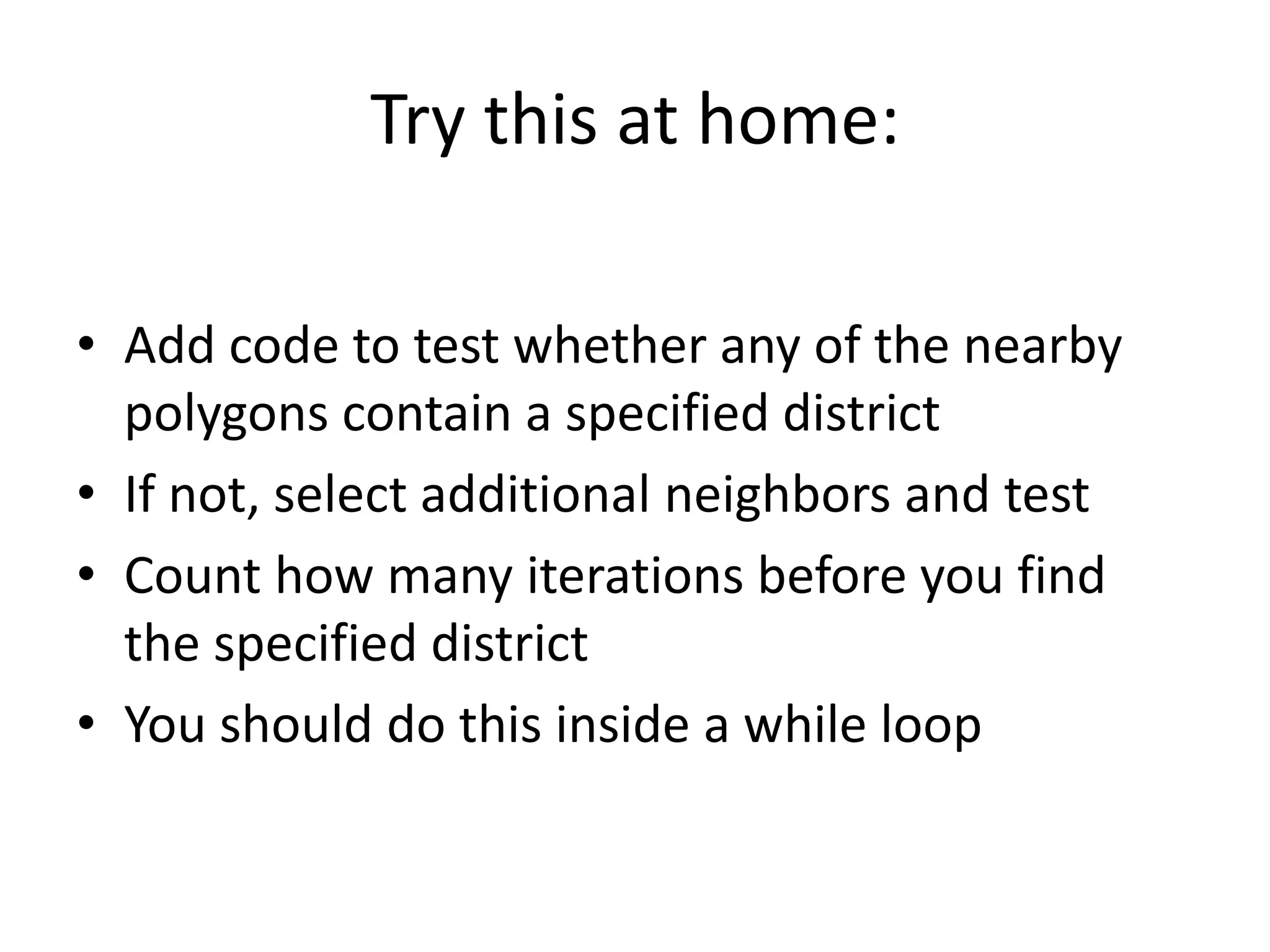

This document provides an outline for a Python programming workshop for ArcGIS. It discusses using Python to access ArcGIS commands, attribute tables, and geometries for geoprocessing. It covers Python data types like lists and tuples, string processing, functions, and accessing attribute tables using search cursors. Exercises demonstrate selecting features by attributes and location using cursors and layers.


![Agentic Systems and Compliance - A brief intro [1.2]](https://cdn.slidesharecdn.com/ss_thumbnails/agenticsystemsandcompliace-1-251018025303-958a42ec-thumbnail.jpg?width=600ounds&width=560&fit=bounds)


![RTP_AR_Basic_Learners' Workbook_KS2 [FOR REPRODUCTION] (1).pdf](https://cdn.slidesharecdn.com/ss_thumbnails/rtparbasiclearnersworkbookks2forreproduction1-251016024943-e51a16ac-thumbnail.jpg?width=600ounds&width=560&fit=bounds)