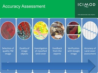
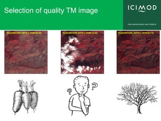
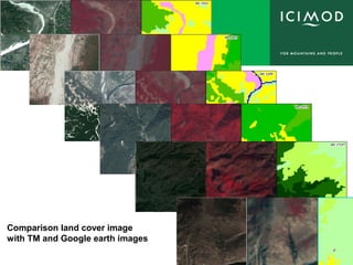
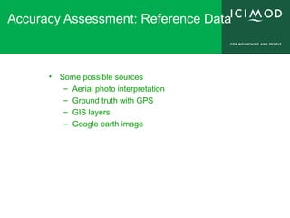
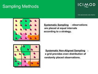
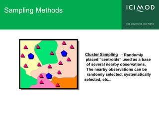
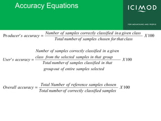
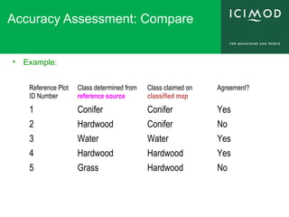
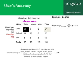
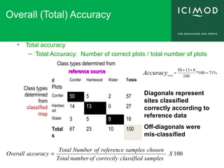
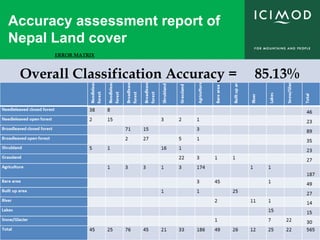
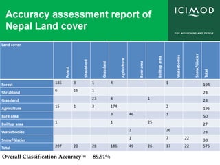
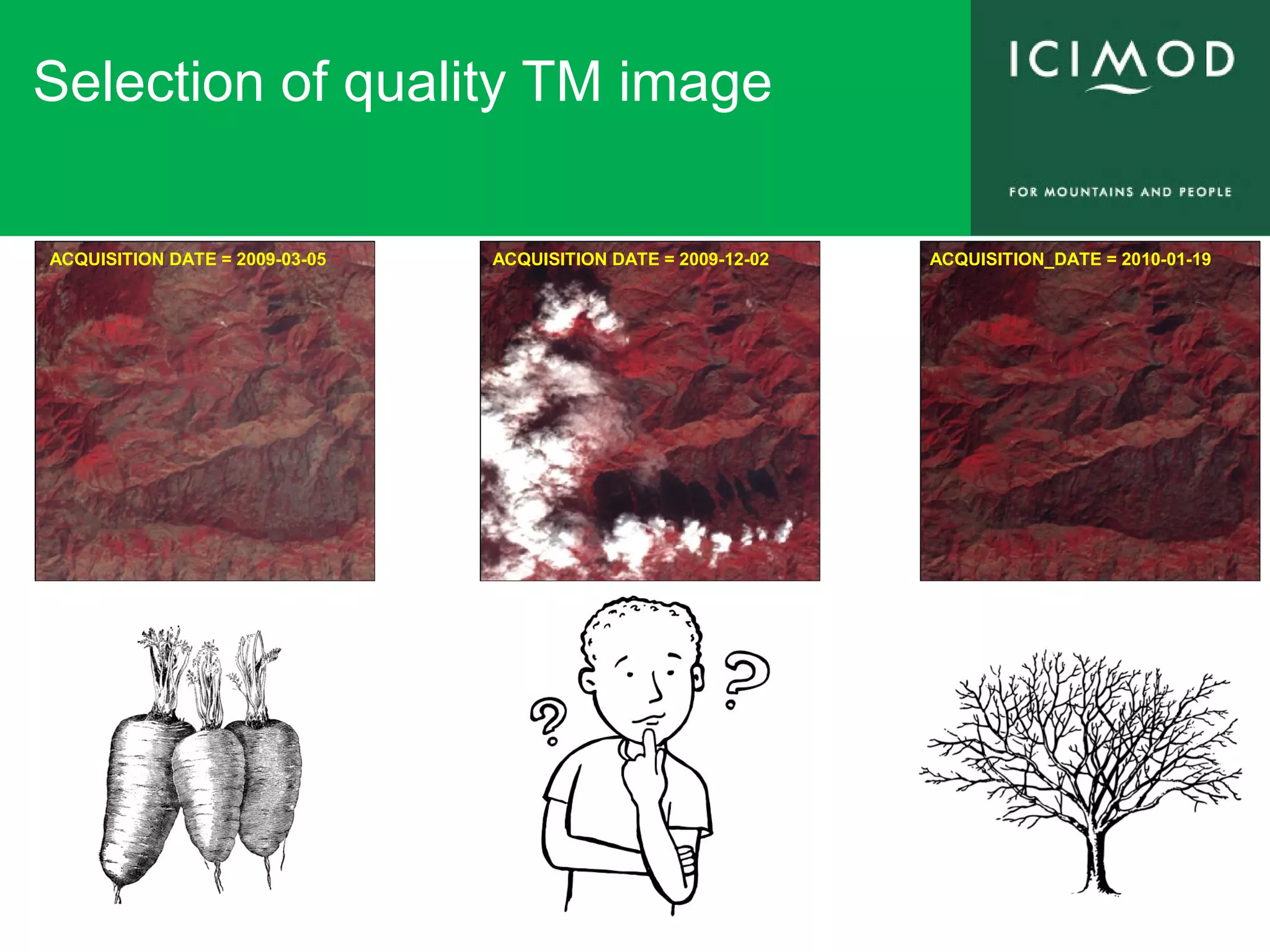
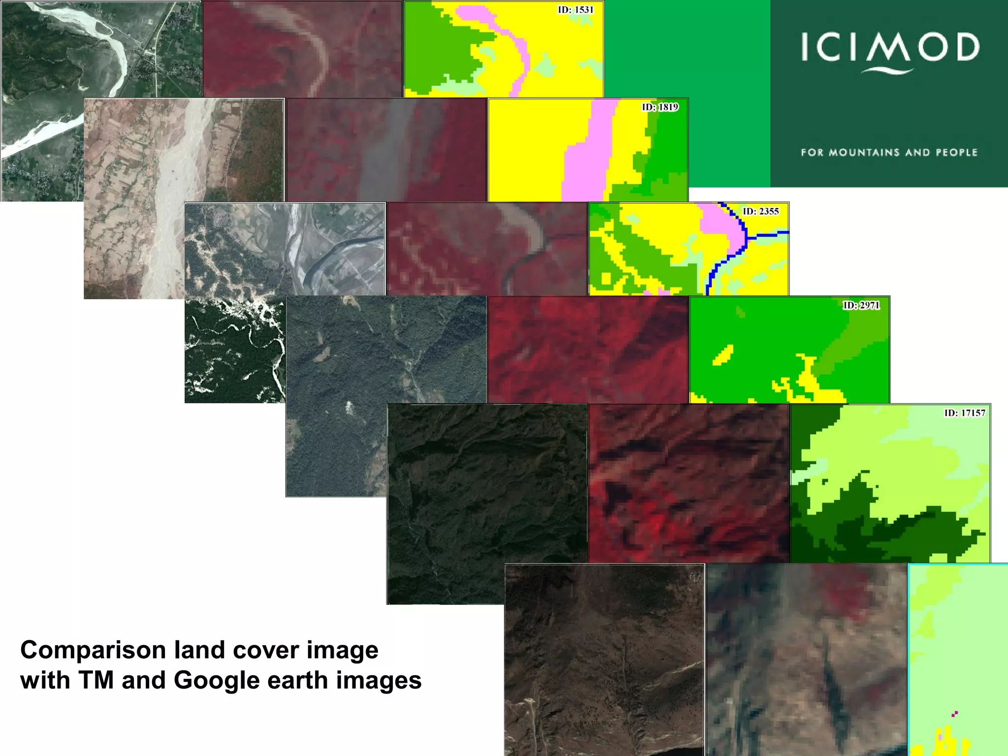
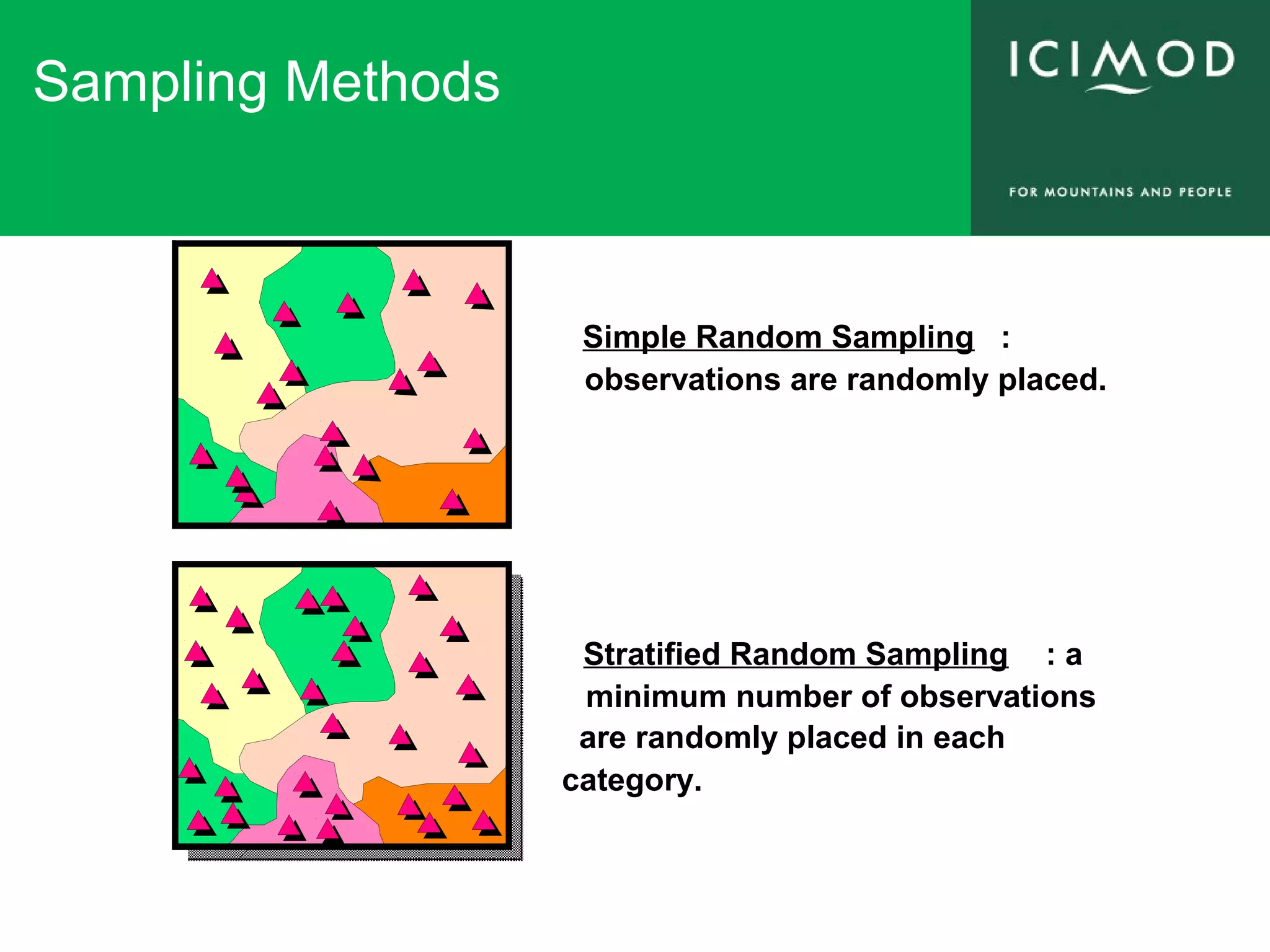
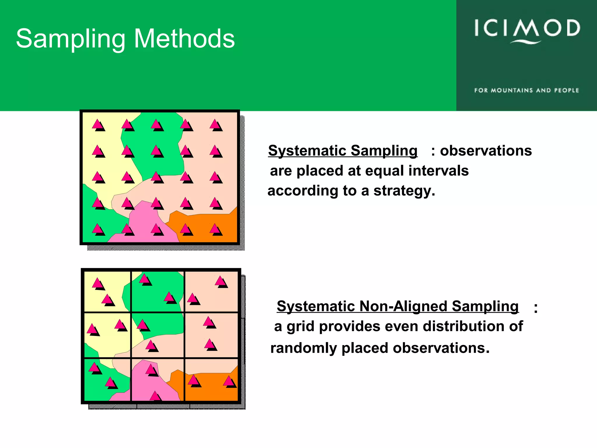
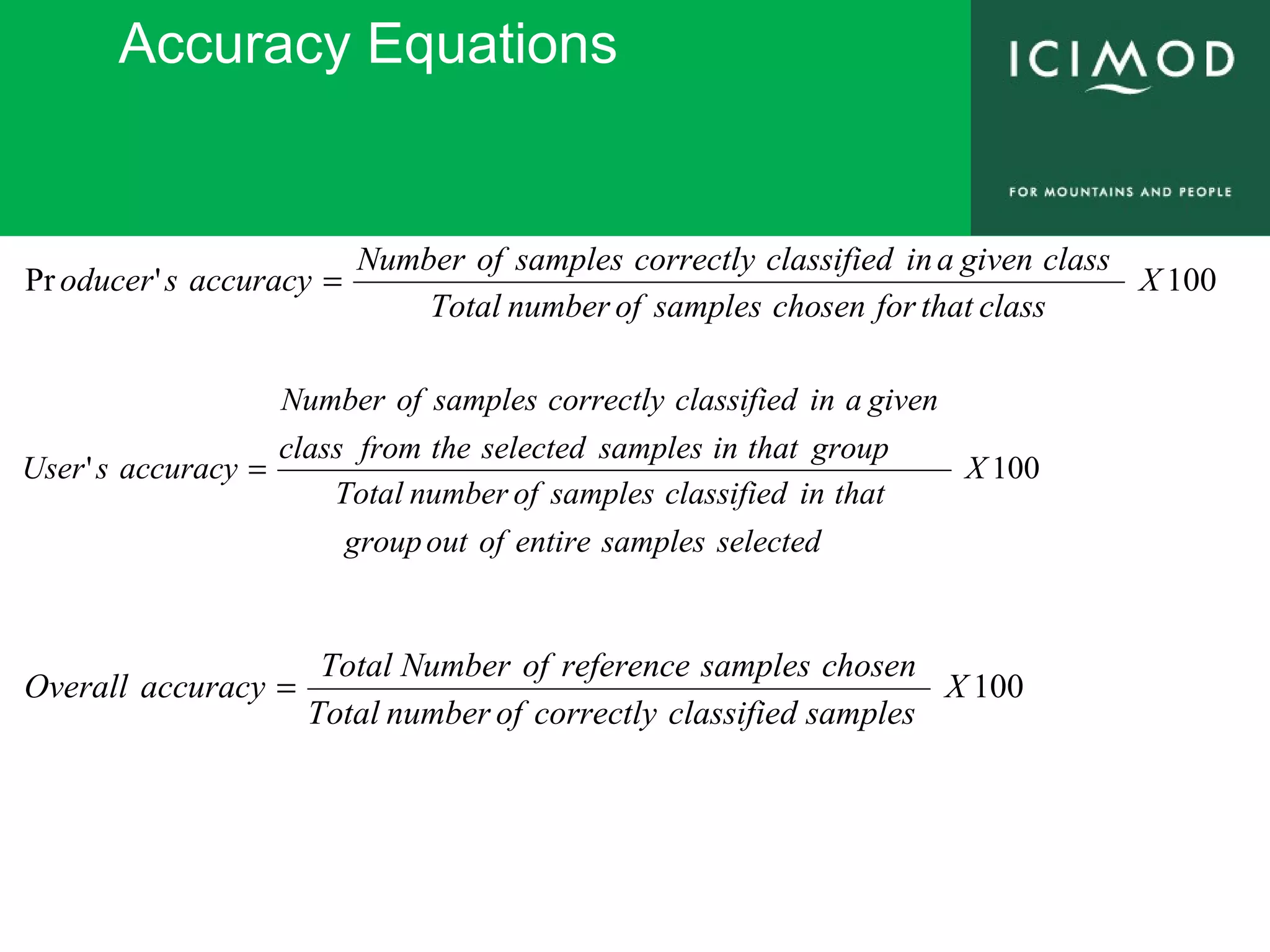
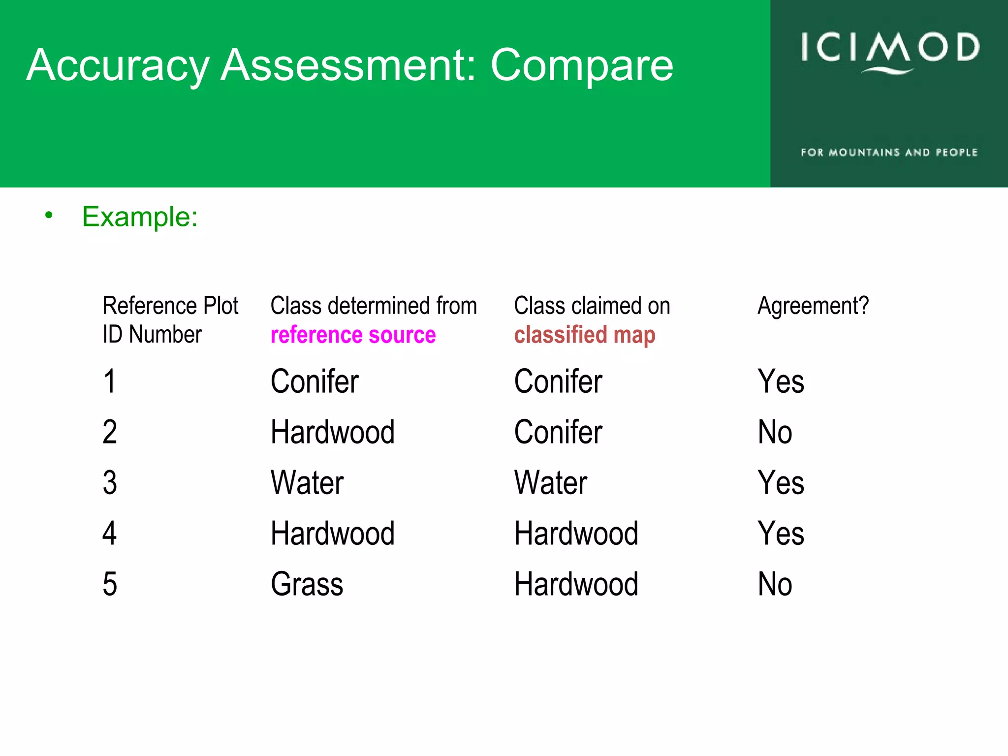
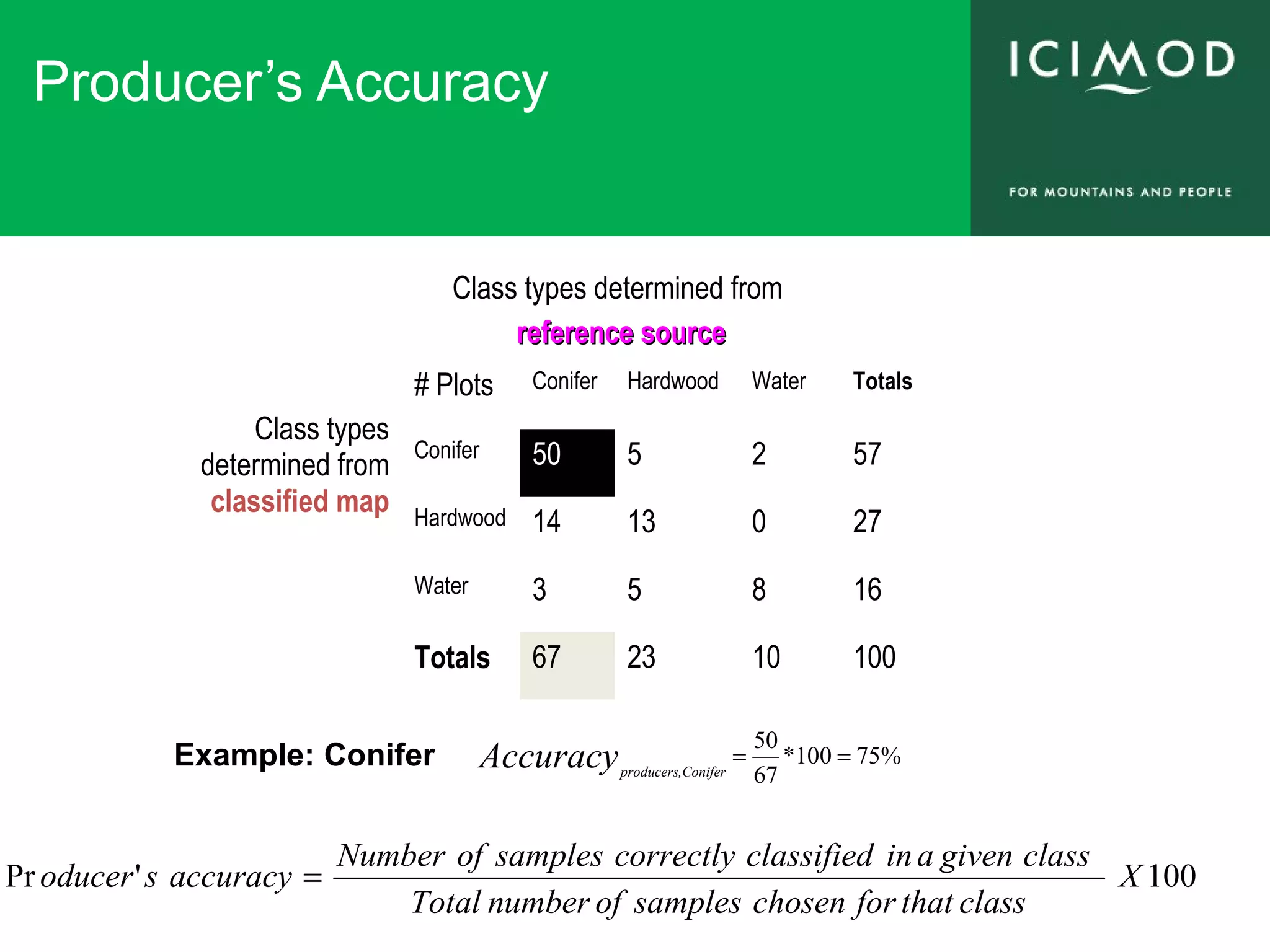
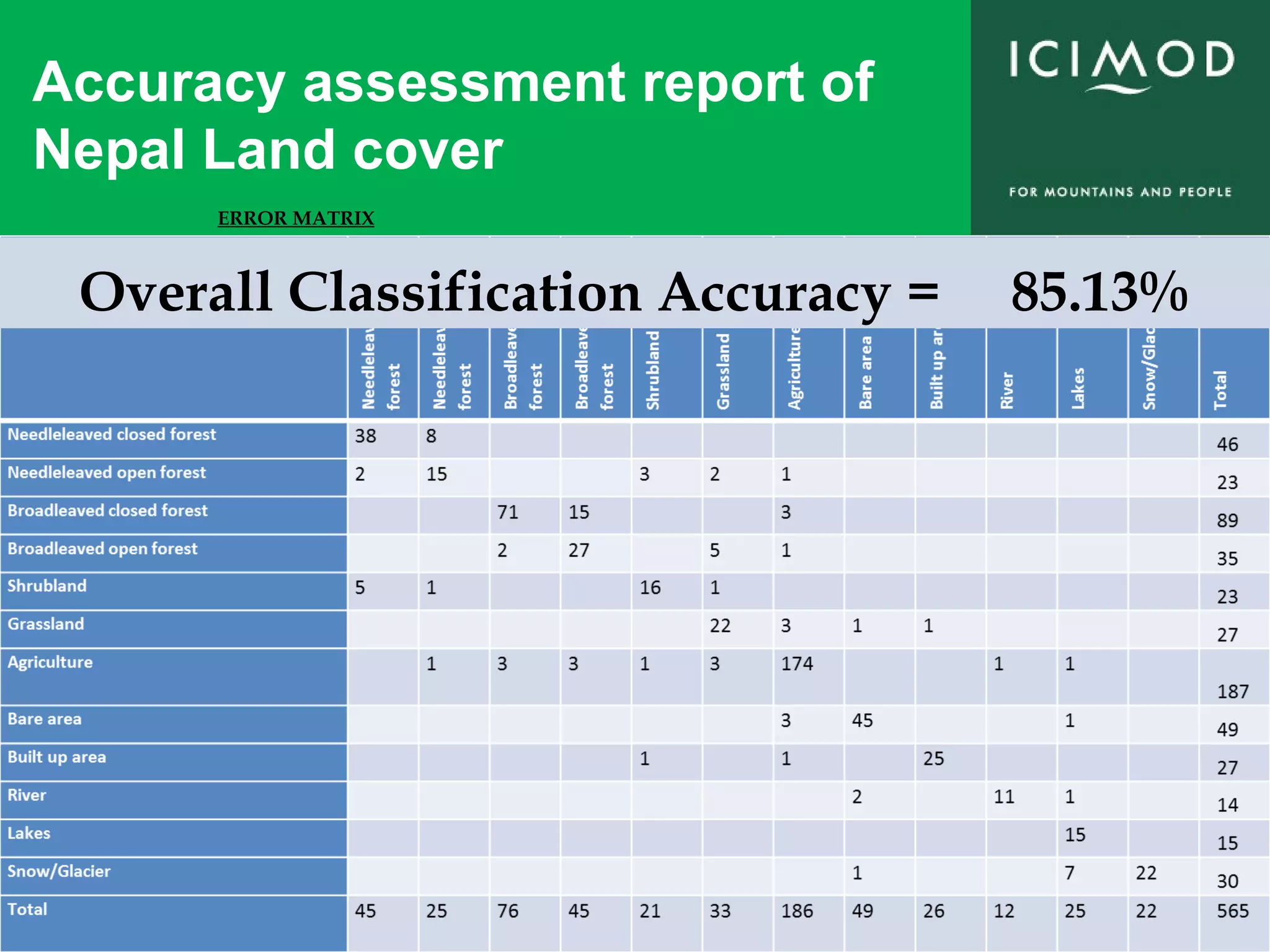
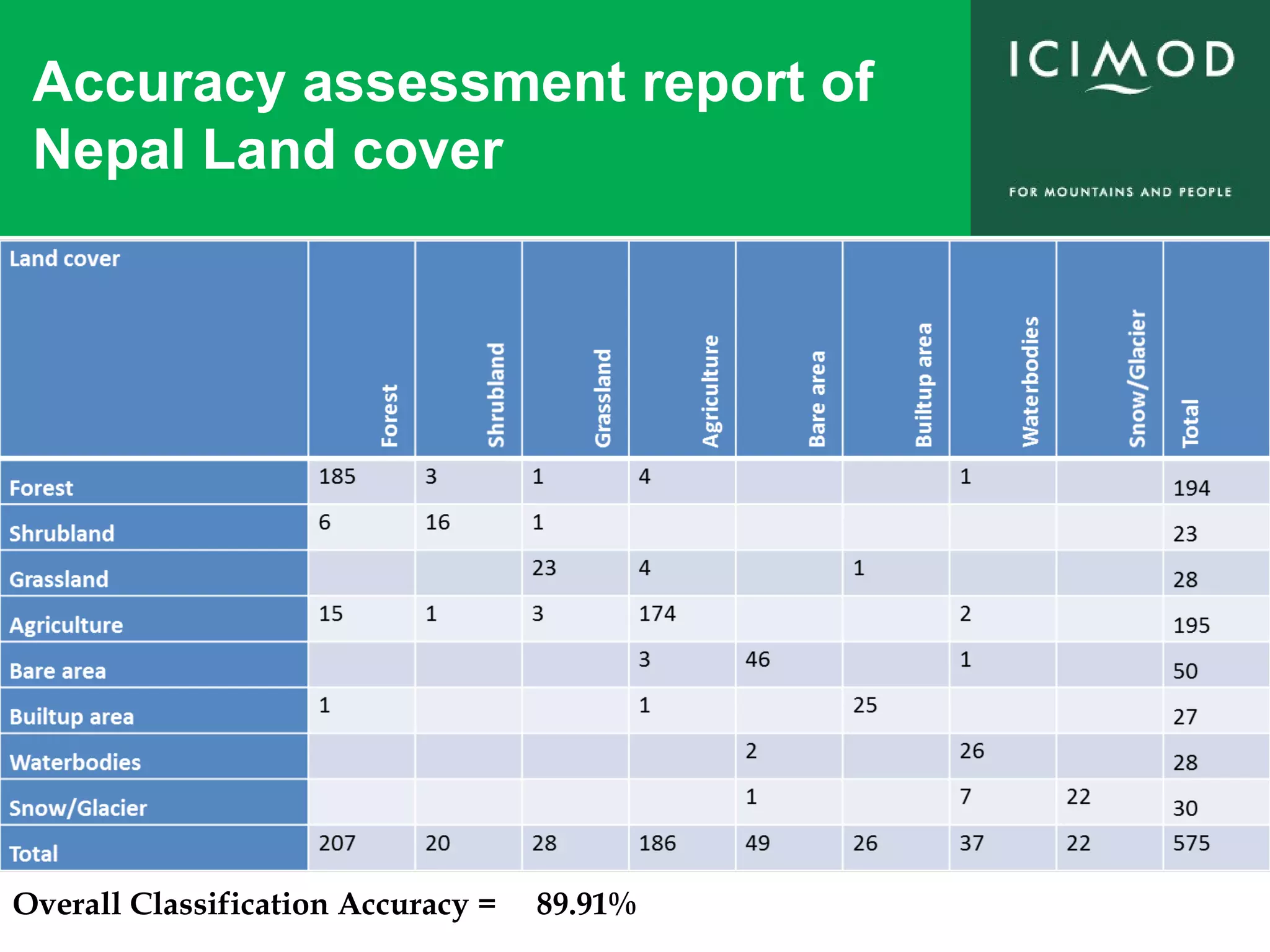
KEMBAR78
Accuracy assessment of land cover | PPT
Accuracy
Assessment of
Land Cover.
Kabir Uddin, GIS and Remote Sensing Specialist
International Centre for Integrated Mountain Development
GPO Box 3226, Kathmandu, Nepal
Tel +977-1-5003222 Fax +977-1-5003277 Web www.icimod.org
Email: Kaibir.Uddin@icimod.org kabir.uddin.bd@gmail.com
Accuracy Assessment
What is the
accuracy of
land cover
Have you done
land cover
validation
Have you done
land cover
validation
Most common questions from the remote
sensing expert about land cover
– Assess how well a classification worked
– Understand how to interpret the usefulness of
someone else’s classification
Accuracy Assessment
Selection of quality TM image
ACQUISITION DATE = 2009-03-05 ACQUISITION DATE = 2009-12-02 ACQUISITION_DATE = 2010-01-19
Comparison land cover image
with TM and Google earth images
Accuracy Assessment: Reference Data
• Some possible sources
– Aerial photo interpretation
– Ground truth with GPS
– GIS layers
– Google earth image
Sampling Methods
Simple Random Sampling :
observations are randomly placed.
Stratified Random Sampling : a
minimum number of observations
are randomly placed in each
category.
Sampling Methods
Systematic Sampling : observations
are placed at equal intervals
according to a strategy.
Systematic Non-Aligned Sampling :
a grid provides even distribution of
randomly placed observations.
Sampling Methods
Cluster Sampling : Randomly
placed “centroids” used as a base
of several nearby observations.
The nearby observations can be
randomly selected, systematically
selected, etc...
Accuracy Equations
100'Pr X
classthatforchosensamplesofnumberTotal
classgivenainclassifiedcorrectlysamplesofNumber
accuracysoducer =
100' X
selectedsamplesentireofoutgroup
thatinclassifiedsamplesofnumberTotal
groupthatinsamplesselectedthefromclass
givenainclassifiedcorrectlysamplesofNumber
accuracysUser =
100X
samplesclassifiedcorrectlyofnumberTotal
chosensamplesreferenceofNumberTotal
accuracyOverall =
Accuracy Assessment: Compare
• Example:
Reference Plot
ID Number
Class determined from
reference source
Class claimed on
classified map
Agreement?
1 Conifer Conifer Yes
2 Hardwood Conifer No
3 Water Water Yes
4 Hardwood Hardwood Yes
5 Grass Hardwood No
User’s Accuracy
Class types determined from
reference sourcereference source
Class types
determined
from
classified
map
# Plots Conifer Hardwood Water Totals
Conifer 50 5 2 57
Hardwood 14 13 0 27
Water 3 5 8 16
Totals 67 23 10 100
%88100*
57
50
,'
==Accuracy ConifersUser
Example: Conifer
100' X
selectedsamplesentireofoutgroup
thatinclassifiedsamplesofnumberTotal
groupthatinsamplesselectedthefromclass
givenainclassifiedcorrectlysamplesofNumber
accuracysUser =
Producer’s Accuracy
Class types determined from
reference sourcereference source
Class types
determined from
classified map
# Plots Conifer Hardwood Water Totals
Conifer 50 5 2 57
Hardwood 14 13 0 27
Water 3 5 8 16
Totals 67 23 10 100
%75100*
67
50
==Accuracy Coniferproducers,
Example: Conifer
100'Pr X
classthatforchosensamplesofnumberTotal
classgivenainclassifiedcorrectlysamplesofNumber
accuracysoducer =
Overall (Total) Accuracy
• Total accuracy
– Total Accuracy: Number of correct plots / total number of plots
Class types determined from
reference sourcereference source
Class types
determined
from
classified
map
#
Plots
Conifer Hardwood Water Totals
Conifer 50 5 2 57
Hardwo
od
14 13 0 27
Water 3 5 8 16
Total
s
67 23 10 100
%71100*
100
81350
=
++
=AccuracyTotal
Diagonals represent
sites classified
correctly according to
reference data
Off-diagonals were
mis-classified
100X
samplesclassifiedcorrectlyofnumberTotal
chosensamplesreferenceofNumberTotal
accuracyOverall =
Accuracy assessment report of
Nepal Land cover
ERROR MATRIX
Overall Classification Accuracy = 85.13%
Accuracy assessment report of
Nepal Land cover
Overall Classification Accuracy = 89.91%
Thank you

Accuracy assessment of land cover

  • 1.
    Accuracy Assessment of Land Cover. KabirUddin, GIS and Remote Sensing Specialist International Centre for Integrated Mountain Development GPO Box 3226, Kathmandu, Nepal Tel +977-1-5003222 Fax +977-1-5003277 Web www.icimod.org Email: Kaibir.Uddin@icimod.org kabir.uddin.bd@gmail.com
  • 2.
    Accuracy Assessment What isthe accuracy of land cover Have you done land cover validation Have you done land cover validation Most common questions from the remote sensing expert about land cover – Assess how well a classification worked – Understand how to interpret the usefulness of someone else’s classification
  • 3.
  • 4.
    Selection of qualityTM image ACQUISITION DATE = 2009-03-05 ACQUISITION DATE = 2009-12-02 ACQUISITION_DATE = 2010-01-19
  • 5.
    Comparison land coverimage with TM and Google earth images
  • 6.
    Accuracy Assessment: ReferenceData • Some possible sources – Aerial photo interpretation – Ground truth with GPS – GIS layers – Google earth image
  • 7.
    Sampling Methods Simple RandomSampling : observations are randomly placed. Stratified Random Sampling : a minimum number of observations are randomly placed in each category.
  • 8.
    Sampling Methods Systematic Sampling: observations are placed at equal intervals according to a strategy. Systematic Non-Aligned Sampling : a grid provides even distribution of randomly placed observations.
  • 9.
    Sampling Methods Cluster Sampling: Randomly placed “centroids” used as a base of several nearby observations. The nearby observations can be randomly selected, systematically selected, etc...
  • 10.
    Accuracy Equations 100'Pr X classthatforchosensamplesofnumberTotal classgivenainclassifiedcorrectlysamplesofNumber accuracysoducer= 100' X selectedsamplesentireofoutgroup thatinclassifiedsamplesofnumberTotal groupthatinsamplesselectedthefromclass givenainclassifiedcorrectlysamplesofNumber accuracysUser = 100X samplesclassifiedcorrectlyofnumberTotal chosensamplesreferenceofNumberTotal accuracyOverall =
  • 11.
    Accuracy Assessment: Compare •Example: Reference Plot ID Number Class determined from reference source Class claimed on classified map Agreement? 1 Conifer Conifer Yes 2 Hardwood Conifer No 3 Water Water Yes 4 Hardwood Hardwood Yes 5 Grass Hardwood No
  • 12.
    User’s Accuracy Class typesdetermined from reference sourcereference source Class types determined from classified map # Plots Conifer Hardwood Water Totals Conifer 50 5 2 57 Hardwood 14 13 0 27 Water 3 5 8 16 Totals 67 23 10 100 %88100* 57 50 ,' ==Accuracy ConifersUser Example: Conifer 100' X selectedsamplesentireofoutgroup thatinclassifiedsamplesofnumberTotal groupthatinsamplesselectedthefromclass givenainclassifiedcorrectlysamplesofNumber accuracysUser =
  • 13.
    Producer’s Accuracy Class typesdetermined from reference sourcereference source Class types determined from classified map # Plots Conifer Hardwood Water Totals Conifer 50 5 2 57 Hardwood 14 13 0 27 Water 3 5 8 16 Totals 67 23 10 100 %75100* 67 50 ==Accuracy Coniferproducers, Example: Conifer 100'Pr X classthatforchosensamplesofnumberTotal classgivenainclassifiedcorrectlysamplesofNumber accuracysoducer =
  • 14.
    Overall (Total) Accuracy •Total accuracy – Total Accuracy: Number of correct plots / total number of plots Class types determined from reference sourcereference source Class types determined from classified map # Plots Conifer Hardwood Water Totals Conifer 50 5 2 57 Hardwo od 14 13 0 27 Water 3 5 8 16 Total s 67 23 10 100 %71100* 100 81350 = ++ =AccuracyTotal Diagonals represent sites classified correctly according to reference data Off-diagonals were mis-classified 100X samplesclassifiedcorrectlyofnumberTotal chosensamplesreferenceofNumberTotal accuracyOverall =
  • 15.
    Accuracy assessment reportof Nepal Land cover ERROR MATRIX Overall Classification Accuracy = 85.13%
  • 16.
    Accuracy assessment reportof Nepal Land cover Overall Classification Accuracy = 89.91%
  • 17.