Download as PDF, PPTX


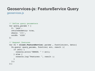
![Terraformer: Geometry and Features
terraformer.js
// create a typed primitive from GeoJSON!
var point = new Terraformer.Primitive({ "type": "Point",
"coordinates": [ 100, 1 ] });!
!
// create a Geometry from coordinates or GeoJSON !
var point = new Terraformer.Point( [ 10, 10 ] );!
var ls = new Terraformer.LineString([ [ 10, 10 ], [ 20, 20 ]]);!
var poly = new Terraformer.Polygon([!
[[100.0, 0.0], [101.0, 0.0], [101.0, 1.0], [100.0, 1.0]]]);!
var circle = new Terraformer.Circle([-122.6764, 45.5165], 1000);!
!
// creates a feature from a valid GeoJSON Object!
var feature = new Terraformer.Feature({"type": "Point",
"coordinates": [ 10, 10 ]}, "properties": {"prop0": "value0"});!
!
!
!](https://image.slidesharecdn.com/app-dev-with-open-source-libs-131113051309-phpapp01/85/Application-devevelopment-with-open-source-libraries-7-320.jpg)
![Terraformer: Geometric Operations
terraformer.js
// to Web Mercator and WGS84!
primitive.toMercator();!
primitive.toGeographic();!
!
var box = poly.bbox;!
var ev = polygon.envelope();!
!
multi.addPoint([ 10, 10 ]);!
multi.insertPoint([ 10, 10 ],1);!
multi.removePoint(1);!
multi.get(1);!
!
polygon1.within(polygon2);!
polygon1.intersects(line);!
polygon1.contains(point);!
circle.contains(point);!
!
!
!
!](https://image.slidesharecdn.com/app-dev-with-open-source-libs-131113051309-phpapp01/85/Application-devevelopment-with-open-source-libraries-8-320.jpg)
![Terraformer: WKT Conversion
terraformer-wkt-parser.js
// take a WKT representation and convert it into a primative !
<script>!
var primitive = Terraformer.WKT.parse('LINESTRING (30 10, 10 30, 40
40)');!
</script>!
!
// take a primitive and convert it into a WKT representation!
var polygon = Terraformer.WKT.convert(!
{!
"type": "Polygon",!
"coordinates": [!
[ [100.0, 0.0], [101.0, 0.0], [101.0, 1.0], [100.0, 1.0],
[100.0, 0.0] ],!
[ [100.2, 0.2], [100.8, 0.2], [100.8, 0.8], [100.2, 0.8],
[100.2, 0.2] ]!
]!
}!
);!](https://image.slidesharecdn.com/app-dev-with-open-source-libs-131113051309-phpapp01/85/Application-devevelopment-with-open-source-libraries-9-320.jpg)
![Terraformer: ArcGIS JSON to GeoJSON
terraformer-arcgis-parser.js
<script>!
// take ArcGIS JSON and convert to Primitive or GeoJSON!
!var primitive = Terraformer.ArcGIS.parse({!
x:"-122.6764",!
y:"45.5165",!
spatialReference: {!
wkid: 4326!
}!
});!
!
// take a Primitive or GeoJSON and convert it to ArcGIS JSON!
var point = Terraformer.ArcGIS.convert({!
"type": "Point",!
"coordinates": [45.5165, -122.6764]!
});!
</script>!](https://image.slidesharecdn.com/app-dev-with-open-source-libs-131113051309-phpapp01/85/Application-devevelopment-with-open-source-libraries-10-320.jpg)


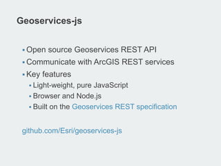
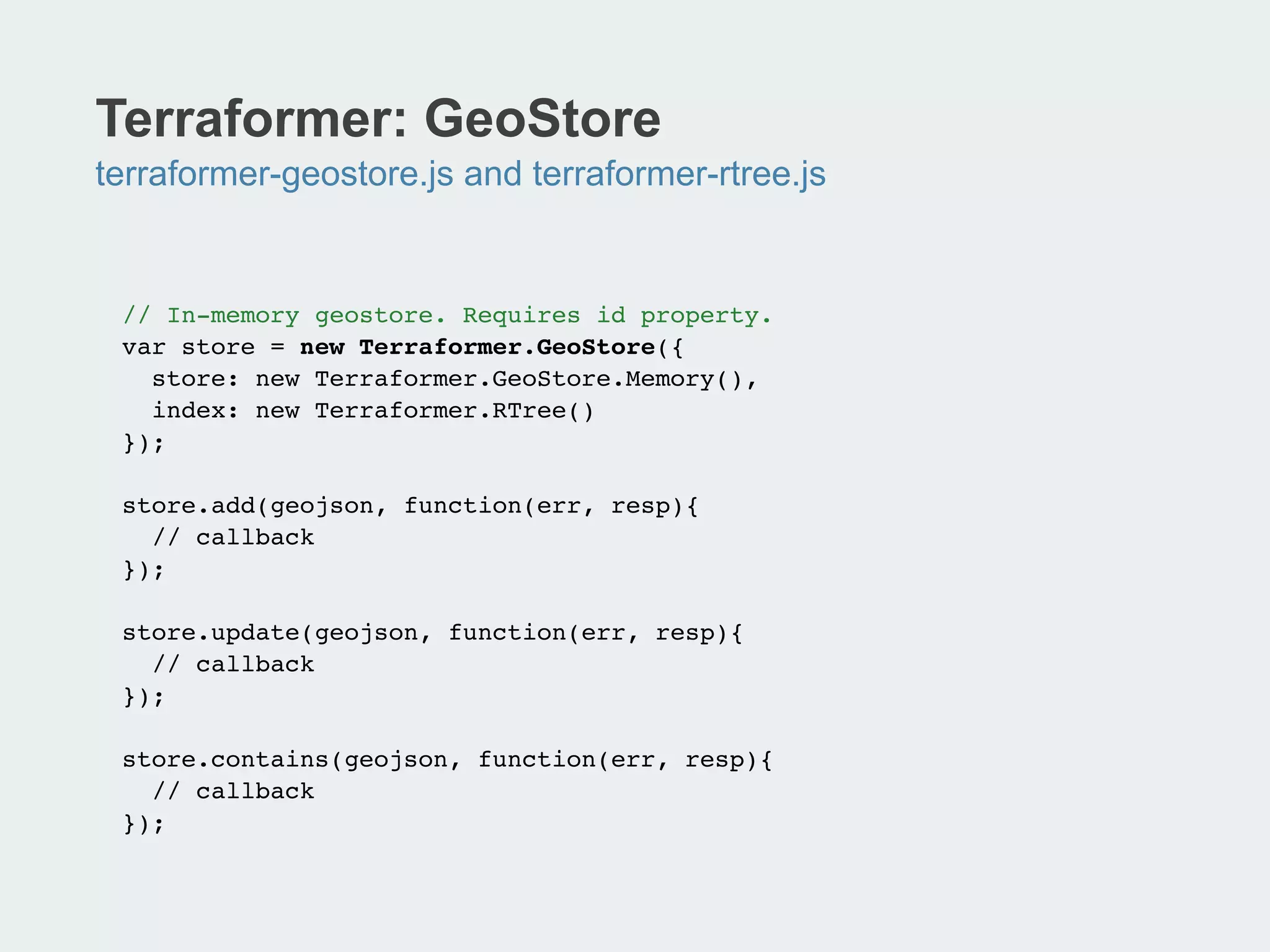
![Geoservices-js: Geocoding
geoservices.js
// Geosearch!
client.geocode({ text: "920 SW 3rd Ave, Portland, OR 97201" },
function (err, result) {!
if (!err) {!
!console.log(result.locations[0].feature.geometry.y + ", " !
!result.locations[0].feature.geometry.x);!
}!
});!
!
// Reverse-geocoding!
client.geocode.reverse({ location: "-122.67633,45.51673" }, !
function (err, result) {!
if (!err){!
console.log(result.address.Address + ", " + result.address.City);
!
}!
});!](https://image.slidesharecdn.com/app-dev-with-open-source-libs-131113051309-phpapp01/85/Application-devevelopment-with-open-source-libraries-18-320.jpg)

![Koop: GitHub Provider Example
MVC
// routes/index.js!
module.exports {!
'get /github/:user/:repo/FeatureServer/:layer/:method': {!
controller: 'github',!
action: 'featureservice'!
},!
…!
// model/github.js!
var Geohub = require('geohub');!
module.exports = {!
find: function( user, repo, file, options, callback ){!
!var key = [ user, repo, file].join('/'),!
!type = 'Github’;!
…!
// controller/index.js!
module.exports = {!
getRepo: function(req, res){!
var _send = function( err, data ){!
…!](https://image.slidesharecdn.com/app-dev-with-open-source-libs-131113051309-phpapp01/85/Application-devevelopment-with-open-source-libraries-24-320.jpg)


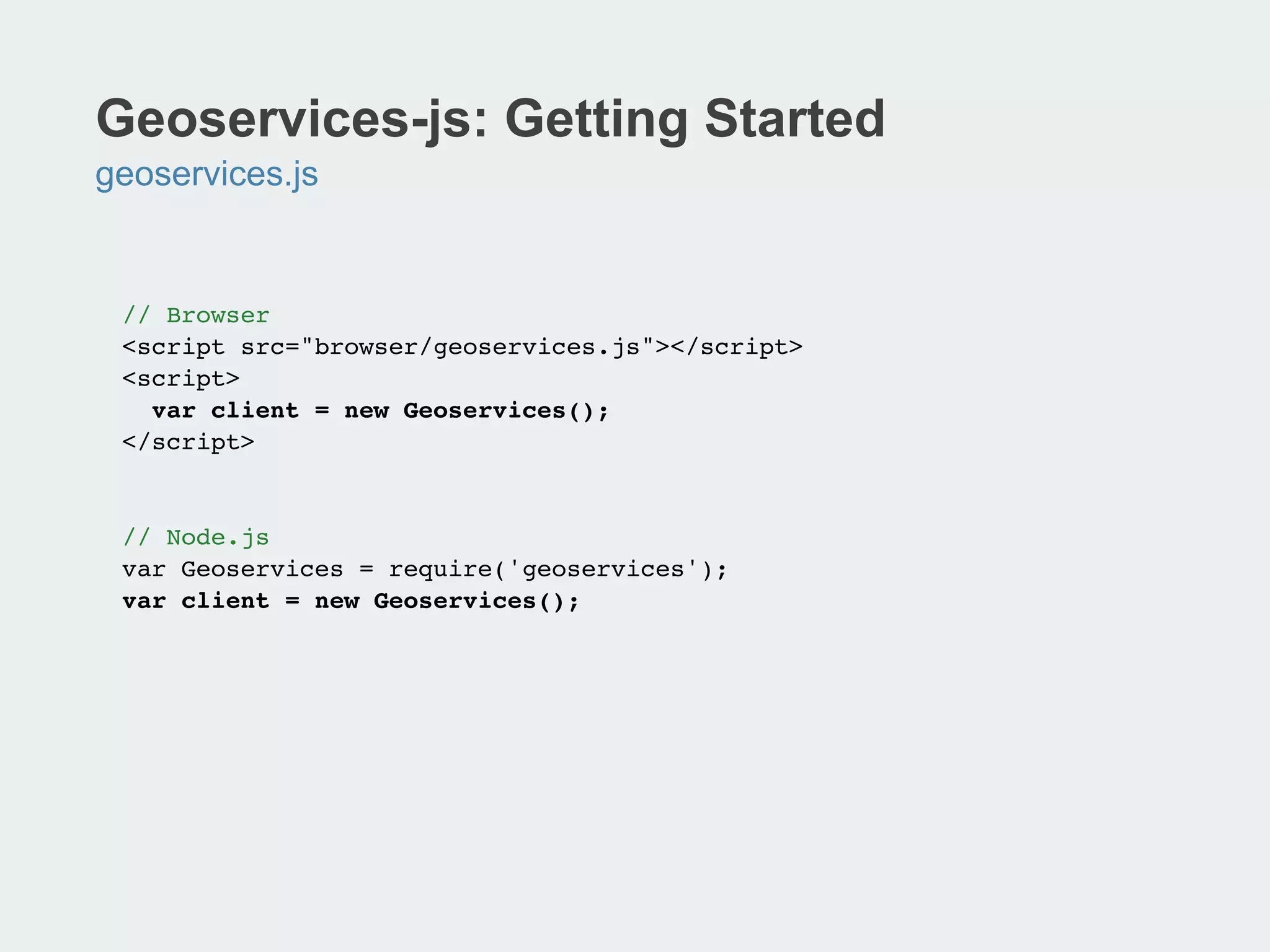
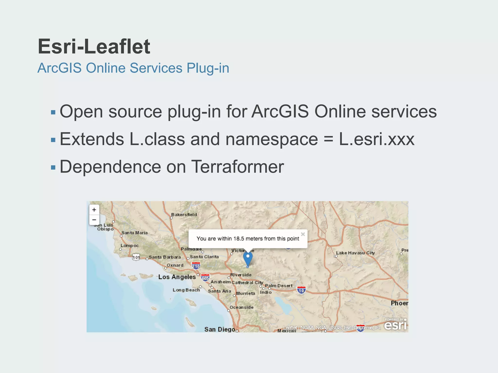
![Esri-Leaflet: Getting Started
Reference L.esri.xxx Library
<!DOCTYPE html>!
<html>!
<head>!
<title>Esri Leaflet</title>!
<link rel="stylesheet" href="/the/path/to/leaflet.css" />
!
!<style>!
html, body, #map { width: 100%; height: 100%; }!
</style>!
!<script src="/the/path/to/leaflet.js"></script>!
<script src="/the/path/to/esri-leaflet.min.js"></script>!
</head>!
<body>!
<div id="map"></div>!
<script>!
!var map = L.map('map');!
!
!L.esri.basemapLayer("Streets").addTo(map);!
!
!map.setView([38.97993, -104.9794], 12);!
!</script>!
</body>!
</html>!](https://image.slidesharecdn.com/app-dev-with-open-source-libs-131113051309-phpapp01/85/Application-devevelopment-with-open-source-libraries-30-320.jpg)
![Esri-Leaflet: ArcGIS Basemaps
L.esri.BasemapLayer = L.TileLayer.extend({…
// Load an ArcGIS basemap!
var map = L.map('map').setView([37.75,-122.45], 12);!
L.esri.basemapLayer("Topographic").addTo(map);!
!
// Supported basemap types!
//L.esri.basemapLayer("Streets").addTo(map);!
//L.esri.basemapLayer("Oceans").addTo(map);!
//L.esri.basemapLayer("NationalGeographic").addTo(map);!
//L.esri.basemapLayer("Gray").addTo(map);!
//L.esri.basemapLayer("GrayLabels").addTo(map);!
//L.esri.basemapLayer("Imagery").addTo(map);!
//L.esri.basemapLayer("ImageryLabels").addTo(map);!
!
!
!
!](https://image.slidesharecdn.com/app-dev-with-open-source-libs-131113051309-phpapp01/85/Application-devevelopment-with-open-source-libraries-31-320.jpg)
![Esri-Leaflet: ArcGIS FeatureServices
L.esri.FeatureLayer = L.GeoJSON.extend({…
// Access ArcGIS FeatureService!
var map = L.map('map').setView([45.52963623111275,
-122.67389774322508], 12);!
L.esri.basemapLayer("Topographic").addTo(map);!
!
var url = 'http://services.arcgis.com/rOo16HdIMeOBI4Mb/
arcgis/rest/services/stops/FeatureServer/0’!
!
L.esri.featureLayer(url);!](https://image.slidesharecdn.com/app-dev-with-open-source-libs-131113051309-phpapp01/85/Application-devevelopment-with-open-source-libraries-32-320.jpg)
![Esri-Leaflet: Popups
// Create FeatureLayer and bind to popup!
L.esri.featureLayer(featureServiceUrl, {!
onEachFeature: createPopup!
}).addTo(map);!
!
// Define popup content - show all fields and values!
function createPopup(geojson,layer) {!
if (geojson.properties) {!
var popupText = "<div style='max-height:200px;'>";!
for (prop in geojson.properties) {!
var val = geojson.properties[prop];!
if (val) {!
popupText += "<b>" + prop + "</b>: " + val + "<br>";!
}!
}!
popupText += "</div>";!
layer.bindPopup(popupText);!
}!
}!](https://image.slidesharecdn.com/app-dev-with-open-source-libs-131113051309-phpapp01/85/Application-devevelopment-with-open-source-libraries-34-320.jpg)
![Esri-Leaflet: DynamicMapLayer
// ArcGIS Server Dynamic Map Service - Hurricane Tracks!
dynLayer = L.esri.dynamicMapLayer("http://
tmservices1.esri.com/arcgis/rest/services/LiveFeeds/
Hurricane_Recent/MapServer", { layers:[0,1] });!
!
// Identifying Dynamic Map Service Features!
map.on("click", function(e) {!
!dynLayer.identify(e.latlng, {!
!
!layerDefs: {!
0: "STORMNAME='ANDREA'",!
1: "STORMNAME='ANDREA'"!
}!
}, function(data) {!
!
!
!popupText = "<center><b>" +!
data.results[0].attributes.STORMNAME + "</b><br>" +!
data.results[0].attributes.STORMTYPE + "</center>”;!
!
!L.popup().setLatLng(e.latlng).setContent
!
!
!
!
!(popupText).openOn(map);!
!}!
!});!
});
!](https://image.slidesharecdn.com/app-dev-with-open-source-libs-131113051309-phpapp01/85/Application-devevelopment-with-open-source-libraries-35-320.jpg)
![Esri-Leaflet: Geocoding
esri-leaflet.js + geoservices.js
// Reference geoservices.js!
<script src="lib/geoservices/geoservices.js"></script>!
…!
var GeoServices = new Geoservices.Geoservices({});!
var options = {!
text:searchString,!
outFields: "Loc_name,Place_addr",!
bbox: mapBounds }!
!
// Add geocodes to map!
GeoServices.geocode(options, function (err,result) {!
!for (var i = 0; i < result.locations.length; i++) {!
var place = result.locations[i];!
var pt = new L.LatLng(place.feature.geometry.y,
place.feature.geometry.x);!
!
!var marker = L.marker(pt).bindPopup(place.name + "</
br>" + place.feature.attributes.Place_addr);!
layerPlaces.addLayer(marker);!
}!
}!
!](https://image.slidesharecdn.com/app-dev-with-open-source-libs-131113051309-phpapp01/85/Application-devevelopment-with-open-source-libraries-38-320.jpg)


![Terraformer: Geometry and Features
terraformer.js
// create a typed primitive from GeoJSON!
var point = new Terraformer.Primitive({ "type": "Point",
"coordinates": [ 100, 1 ] });!
!
// create a Geometry from coordinates or GeoJSON !
var point = new Terraformer.Point( [ 10, 10 ] );!
var ls = new Terraformer.LineString([ [ 10, 10 ], [ 20, 20 ]]);!
var poly = new Terraformer.Polygon([!
[[100.0, 0.0], [101.0, 0.0], [101.0, 1.0], [100.0, 1.0]]]);!
var circle = new Terraformer.Circle([-122.6764, 45.5165], 1000);!
!
// creates a feature from a valid GeoJSON Object!
var feature = new Terraformer.Feature({"type": "Point",
"coordinates": [ 10, 10 ]}, "properties": {"prop0": "value0"});!
!
!
!](https://image.slidesharecdn.com/app-dev-with-open-source-libs-131113051309-phpapp01/75/Application-devevelopment-with-open-source-libraries-7-2048.jpg)
![Terraformer: Geometric Operations
terraformer.js
// to Web Mercator and WGS84!
primitive.toMercator();!
primitive.toGeographic();!
!
var box = poly.bbox;!
var ev = polygon.envelope();!
!
multi.addPoint([ 10, 10 ]);!
multi.insertPoint([ 10, 10 ],1);!
multi.removePoint(1);!
multi.get(1);!
!
polygon1.within(polygon2);!
polygon1.intersects(line);!
polygon1.contains(point);!
circle.contains(point);!
!
!
!
!](https://image.slidesharecdn.com/app-dev-with-open-source-libs-131113051309-phpapp01/75/Application-devevelopment-with-open-source-libraries-8-2048.jpg)
![Terraformer: WKT Conversion
terraformer-wkt-parser.js
// take a WKT representation and convert it into a primative !
<script>!
var primitive = Terraformer.WKT.parse('LINESTRING (30 10, 10 30, 40
40)');!
</script>!
!
// take a primitive and convert it into a WKT representation!
var polygon = Terraformer.WKT.convert(!
{!
"type": "Polygon",!
"coordinates": [!
[ [100.0, 0.0], [101.0, 0.0], [101.0, 1.0], [100.0, 1.0],
[100.0, 0.0] ],!
[ [100.2, 0.2], [100.8, 0.2], [100.8, 0.8], [100.2, 0.8],
[100.2, 0.2] ]!
]!
}!
);!](https://image.slidesharecdn.com/app-dev-with-open-source-libs-131113051309-phpapp01/75/Application-devevelopment-with-open-source-libraries-9-2048.jpg)
![Terraformer: ArcGIS JSON to GeoJSON
terraformer-arcgis-parser.js
<script>!
// take ArcGIS JSON and convert to Primitive or GeoJSON!
!var primitive = Terraformer.ArcGIS.parse({!
x:"-122.6764",!
y:"45.5165",!
spatialReference: {!
wkid: 4326!
}!
});!
!
// take a Primitive or GeoJSON and convert it to ArcGIS JSON!
var point = Terraformer.ArcGIS.convert({!
"type": "Point",!
"coordinates": [45.5165, -122.6764]!
});!
</script>!](https://image.slidesharecdn.com/app-dev-with-open-source-libs-131113051309-phpapp01/75/Application-devevelopment-with-open-source-libraries-10-2048.jpg)


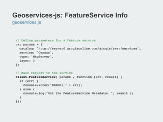
![Geoservices-js: Geocoding
geoservices.js
// Geosearch!
client.geocode({ text: "920 SW 3rd Ave, Portland, OR 97201" },
function (err, result) {!
if (!err) {!
!console.log(result.locations[0].feature.geometry.y + ", " !
!result.locations[0].feature.geometry.x);!
}!
});!
!
// Reverse-geocoding!
client.geocode.reverse({ location: "-122.67633,45.51673" }, !
function (err, result) {!
if (!err){!
console.log(result.address.Address + ", " + result.address.City);
!
}!
});!](https://image.slidesharecdn.com/app-dev-with-open-source-libs-131113051309-phpapp01/75/Application-devevelopment-with-open-source-libraries-18-2048.jpg)

![Koop: GitHub Provider Example
MVC
// routes/index.js!
module.exports {!
'get /github/:user/:repo/FeatureServer/:layer/:method': {!
controller: 'github',!
action: 'featureservice'!
},!
…!
// model/github.js!
var Geohub = require('geohub');!
module.exports = {!
find: function( user, repo, file, options, callback ){!
!var key = [ user, repo, file].join('/'),!
!type = 'Github’;!
…!
// controller/index.js!
module.exports = {!
getRepo: function(req, res){!
var _send = function( err, data ){!
…!](https://image.slidesharecdn.com/app-dev-with-open-source-libs-131113051309-phpapp01/75/Application-devevelopment-with-open-source-libraries-24-2048.jpg)

![Esri-Leaflet: Getting Started
Reference L.esri.xxx Library
<!DOCTYPE html>!
<html>!
<head>!
<title>Esri Leaflet</title>!
<link rel="stylesheet" href="/the/path/to/leaflet.css" />
!
!<style>!
html, body, #map { width: 100%; height: 100%; }!
</style>!
!<script src="/the/path/to/leaflet.js"></script>!
<script src="/the/path/to/esri-leaflet.min.js"></script>!
</head>!
<body>!
<div id="map"></div>!
<script>!
!var map = L.map('map');!
!
!L.esri.basemapLayer("Streets").addTo(map);!
!
!map.setView([38.97993, -104.9794], 12);!
!</script>!
</body>!
</html>!](https://image.slidesharecdn.com/app-dev-with-open-source-libs-131113051309-phpapp01/75/Application-devevelopment-with-open-source-libraries-30-2048.jpg)
![Esri-Leaflet: ArcGIS Basemaps
L.esri.BasemapLayer = L.TileLayer.extend({…
// Load an ArcGIS basemap!
var map = L.map('map').setView([37.75,-122.45], 12);!
L.esri.basemapLayer("Topographic").addTo(map);!
!
// Supported basemap types!
//L.esri.basemapLayer("Streets").addTo(map);!
//L.esri.basemapLayer("Oceans").addTo(map);!
//L.esri.basemapLayer("NationalGeographic").addTo(map);!
//L.esri.basemapLayer("Gray").addTo(map);!
//L.esri.basemapLayer("GrayLabels").addTo(map);!
//L.esri.basemapLayer("Imagery").addTo(map);!
//L.esri.basemapLayer("ImageryLabels").addTo(map);!
!
!
!
!](https://image.slidesharecdn.com/app-dev-with-open-source-libs-131113051309-phpapp01/75/Application-devevelopment-with-open-source-libraries-31-2048.jpg)
![Esri-Leaflet: ArcGIS FeatureServices
L.esri.FeatureLayer = L.GeoJSON.extend({…
// Access ArcGIS FeatureService!
var map = L.map('map').setView([45.52963623111275,
-122.67389774322508], 12);!
L.esri.basemapLayer("Topographic").addTo(map);!
!
var url = 'http://services.arcgis.com/rOo16HdIMeOBI4Mb/
arcgis/rest/services/stops/FeatureServer/0’!
!
L.esri.featureLayer(url);!](https://image.slidesharecdn.com/app-dev-with-open-source-libs-131113051309-phpapp01/75/Application-devevelopment-with-open-source-libraries-32-2048.jpg)
![Esri-Leaflet: Popups
// Create FeatureLayer and bind to popup!
L.esri.featureLayer(featureServiceUrl, {!
onEachFeature: createPopup!
}).addTo(map);!
!
// Define popup content - show all fields and values!
function createPopup(geojson,layer) {!
if (geojson.properties) {!
var popupText = "<div style='max-height:200px;'>";!
for (prop in geojson.properties) {!
var val = geojson.properties[prop];!
if (val) {!
popupText += "<b>" + prop + "</b>: " + val + "<br>";!
}!
}!
popupText += "</div>";!
layer.bindPopup(popupText);!
}!
}!](https://image.slidesharecdn.com/app-dev-with-open-source-libs-131113051309-phpapp01/75/Application-devevelopment-with-open-source-libraries-34-2048.jpg)
![Esri-Leaflet: DynamicMapLayer
// ArcGIS Server Dynamic Map Service - Hurricane Tracks!
dynLayer = L.esri.dynamicMapLayer("http://
tmservices1.esri.com/arcgis/rest/services/LiveFeeds/
Hurricane_Recent/MapServer", { layers:[0,1] });!
!
// Identifying Dynamic Map Service Features!
map.on("click", function(e) {!
!dynLayer.identify(e.latlng, {!
!
!layerDefs: {!
0: "STORMNAME='ANDREA'",!
1: "STORMNAME='ANDREA'"!
}!
}, function(data) {!
!
!
!popupText = "<center><b>" +!
data.results[0].attributes.STORMNAME + "</b><br>" +!
data.results[0].attributes.STORMTYPE + "</center>”;!
!
!L.popup().setLatLng(e.latlng).setContent
!
!
!
!
!(popupText).openOn(map);!
!}!
!});!
});
!](https://image.slidesharecdn.com/app-dev-with-open-source-libs-131113051309-phpapp01/75/Application-devevelopment-with-open-source-libraries-35-2048.jpg)
![Esri-Leaflet: Geocoding
esri-leaflet.js + geoservices.js
// Reference geoservices.js!
<script src="lib/geoservices/geoservices.js"></script>!
…!
var GeoServices = new Geoservices.Geoservices({});!
var options = {!
text:searchString,!
outFields: "Loc_name,Place_addr",!
bbox: mapBounds }!
!
// Add geocodes to map!
GeoServices.geocode(options, function (err,result) {!
!for (var i = 0; i < result.locations.length; i++) {!
var place = result.locations[i];!
var pt = new L.LatLng(place.feature.geometry.y,
place.feature.geometry.x);!
!
!var marker = L.marker(pt).bindPopup(place.name + "</
br>" + place.feature.attributes.Place_addr);!
layerPlaces.addLayer(marker);!
}!
}!
!](https://image.slidesharecdn.com/app-dev-with-open-source-libs-131113051309-phpapp01/75/Application-devevelopment-with-open-source-libraries-38-2048.jpg)


The document discusses the use of open-source libraries for application development, specifically focusing on the Terrafornmer and Geoservices libraries for geospatial data handling in JavaScript. Key features include geometry operations, data storage solutions, and integration with ArcGIS services. The document serves as a guide for setting up and using these libraries for geocoding, features querying, and map display functionalities.


